GEMOC ARC National Key Centre
Fiordland - New Zealand
Fiordland is located in the SW of the South Island of New Zealand (see below). Northern Fiordland exposes the boundary between pristine arc rocks (Median Batholith - green) and a belt of Paleozoic ortho- and paragneisses of variable age that represent the metamorphosed paleo-Pacific Gondwana margin (Western Province - yellow). The region exposes the lower crustal roots (depths > 45 km) of a doubly thickened Mesozoic magmatic arc that now forms one of Earth's youngest extensive high-P granulite facies belts (P = 14 kbar). An Early Cretaceous batholith, the Western Fiordland Orthogneiss (red), stitches the pristine Mesozoic arc rocks with rocks of the Gondwana margin.
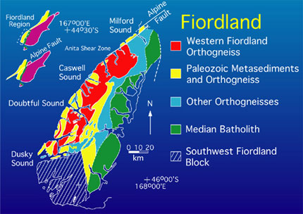
The structural and metamorphic evolution of northern Fiordland involved emplacement of the 116-126 Ma Western Fiordland Orthogneiss batholith (red) at middle to lower crustal conditions, possibly at the root of an arc of normal thickness (20-25 km). Garnet granulite coronas on enstatite and hornblende, in garnet reaction zones, indicate that the terrain was buried by approximately 25 km of crust after emplacement. The two-sided fold-thrust belt at Caswell Sound suggests that loading was accomplished via the tectonic imbrication of thrust sheets, possibly during accretion of the arc to the paleo-Pacific margin of Gondwana. Continued convergence developed high-P pure-shear-dominated shear zones and ductile thrust faults in the Pembroke Granulite. Pronounced high-P cooling of the doubly thickened root of the arc occurred prior to unroofing of the high-P rocks, possibly in response to the tectonic burial and underthrusting of the relatively cold crust of the Median Batholith. The Anita shear zone developed at high-P (P = 12 kbar) and initiated the exhumation of the high-P rocks. Final uplift to the surface is most probably the result of Late Tertiary motion on the Alpine Fault.
|
|