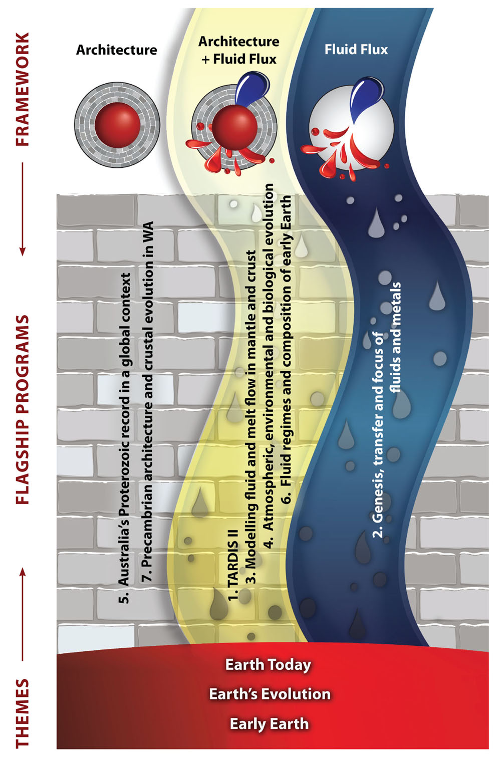
Research Highlights 2018
Following the new conceptual framework outlined here, these Research Highlights are identified as contributing to understanding Earth Architecture (the roadmap for fluids) and/or Fluid Fluxes (the “traffic report”), with logos for easy attribution. For a full description of the Foundation Programs, see Appendix 1. and for the Flagship Programs see Appendix 2.
At the end of the rainbow - Where is the pot of gold?
The nobility of gold, along with its high conductivity, ductility and especially its rarity have made it one of the most desired commodities in the history of humanity. Despite seven millennia of mining, the processes that locally enrich Au in the Earth are still enigmatic. Understanding these processes is becoming increasingly important as fewer new large gold deposits are being discovered, leading to claims that ‘peak gold’ production has been reached. Most previous geological studies on Au have investigated crustal processes related to the formation of Au deposits. However, the ultimate source of the gold remains poorly constrained. Gold has been one of the least studied elements in the mantle. There are several reasons for this, including the fact that Au occurs in low levels in the mantle, making analysis difficult, and the mono-isotopic nature of Au makes isotope dilution, the technique commonly used to analyse the geochemically similar platinum group elements (PGE), impossible.
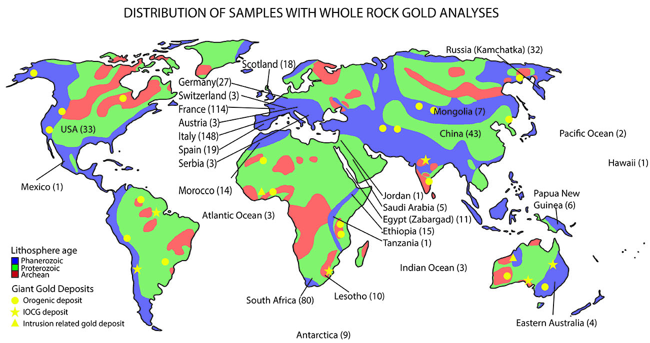
Figure 1. Global map showing distribution of upper mantle samples included in this study. Lithospheric ages simplified from the data in Artemieva (2006). Note: Location of giant gold deposits (classified as containing >500 t Au) from Groves et al. (2016).
We have compiled whole-rock analyses in mantle rocks (CCFS publication #1206) to investigate the abundance of gold in the lithospheric mantle, and how this distribution can be modified. This is the first time such an extensive database has been compiled for Au in mantle rocks, and several surprising results have emerged, including:
1. Modern lithospheric mantle has similar gold concentrations to the primitive upper mantle and the average continental crust, indicating that the lithospheric mantle has not been significantly depleted in Au over the course of Earth’s history. This contrasts with previous suggestions that the primitive mantle was enriched in Au, making it a more fertile source for Au mineralisation in the Archean.
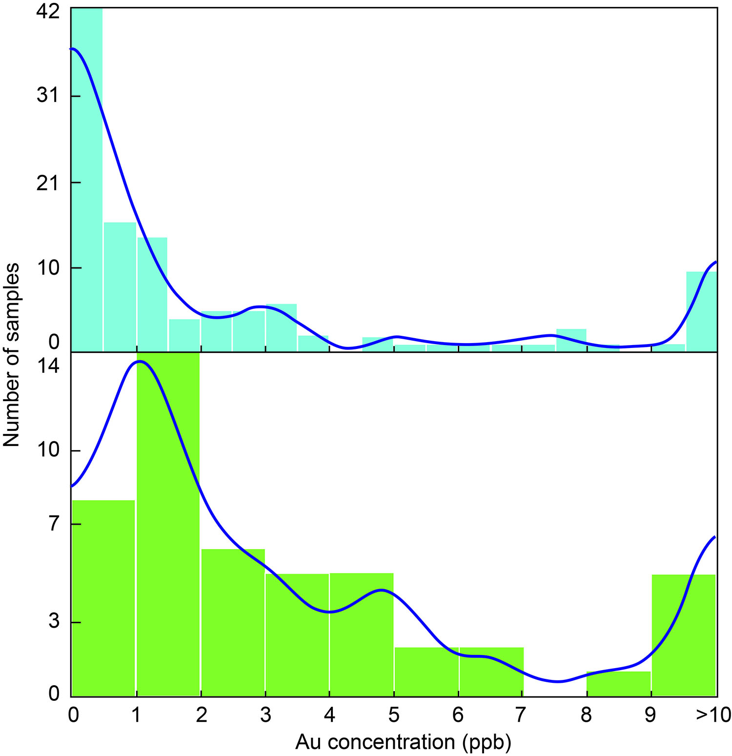
Figure 2. Histograms for Au concentrations in different lithologies: (a) dunite and harzburgite samples (n = 116); (b) pyroxenite samples (n = 48). All analyses >10 ppb have been included together on far right of histogram.
2. The lithospheric mantle has a relatively homogenous Au distribution, with the exception of the North China Craton, which appears to be anomalously enriched in Au. This enrichment is likely the result of the unique ‘decratonisation’ event that the region underwent in the Mesozoic.
3. Au shows no systematic relationship with the LILE, and does not appear to be enriched by hydrous fluids in the mantle, which strongly contrasts with its behaviour in the crust. There is likewise no evidence that Au is enriched by carbonatitic metasomatism in the mantle. It may, however, be enriched by silicate melts in the mantle.
4. Au content of pyroxenites is commonly elevated relative to that of peridotites in the lithospheric mantle (median Au-in-pyroxenite = 2.0 ppb; median Au-in-peridotite = 1.2 ppb). The data indicate that the melts from which these pyroxenites have crystallised may be effective metasomatic agents within the lithospheric mantle. Such gold-rich pyroxenites and related magmas may play an important role in crustal mineralisation processes.
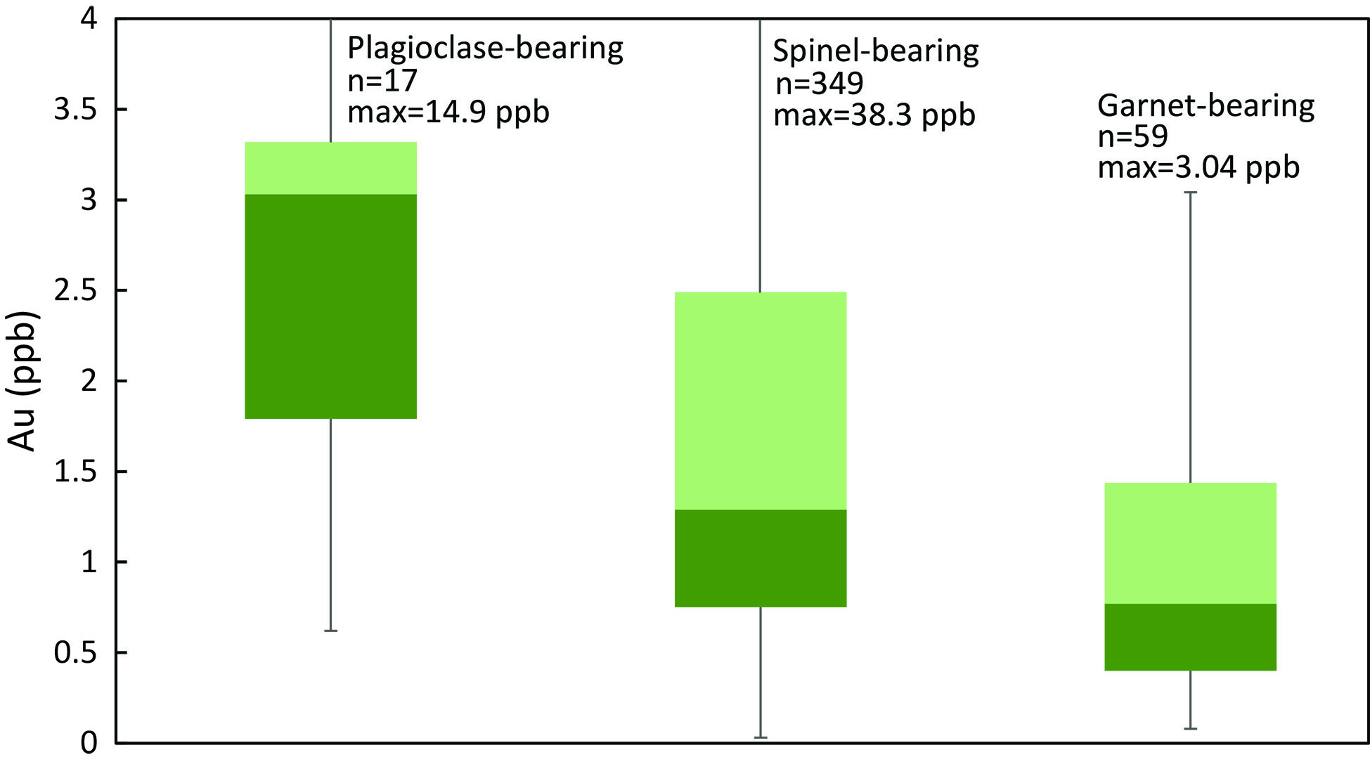
Figure 3. Box-and-whisker plots showing the decrease in Au with depth (from shallow, plagioclase-bearing peridotites on the left to deep, garnet-bearing peridotites on the right) in the lithospheric mantle.
In summary:
• Au contents in the subcontinental lithospheric mantle (SCLM), primitive upper mantle and crust are comparable, likely indicating efficient recycling through Earth history at least post-Archean
• The median Au contents in metasomatised, refertilised SCLM are higher than those in depleted and primitive SCLM
• Au is not sourced from subducted oceanic lithosphere but from asthenosphere
• Au is transported in silicate melts (evidenced by mantle pyroxenites), and not by “fluids”
• Shallow SCLM is most Au-enriched (indicating Au is upwardly mobile via silicate melt movement) in the lithospheric mantle
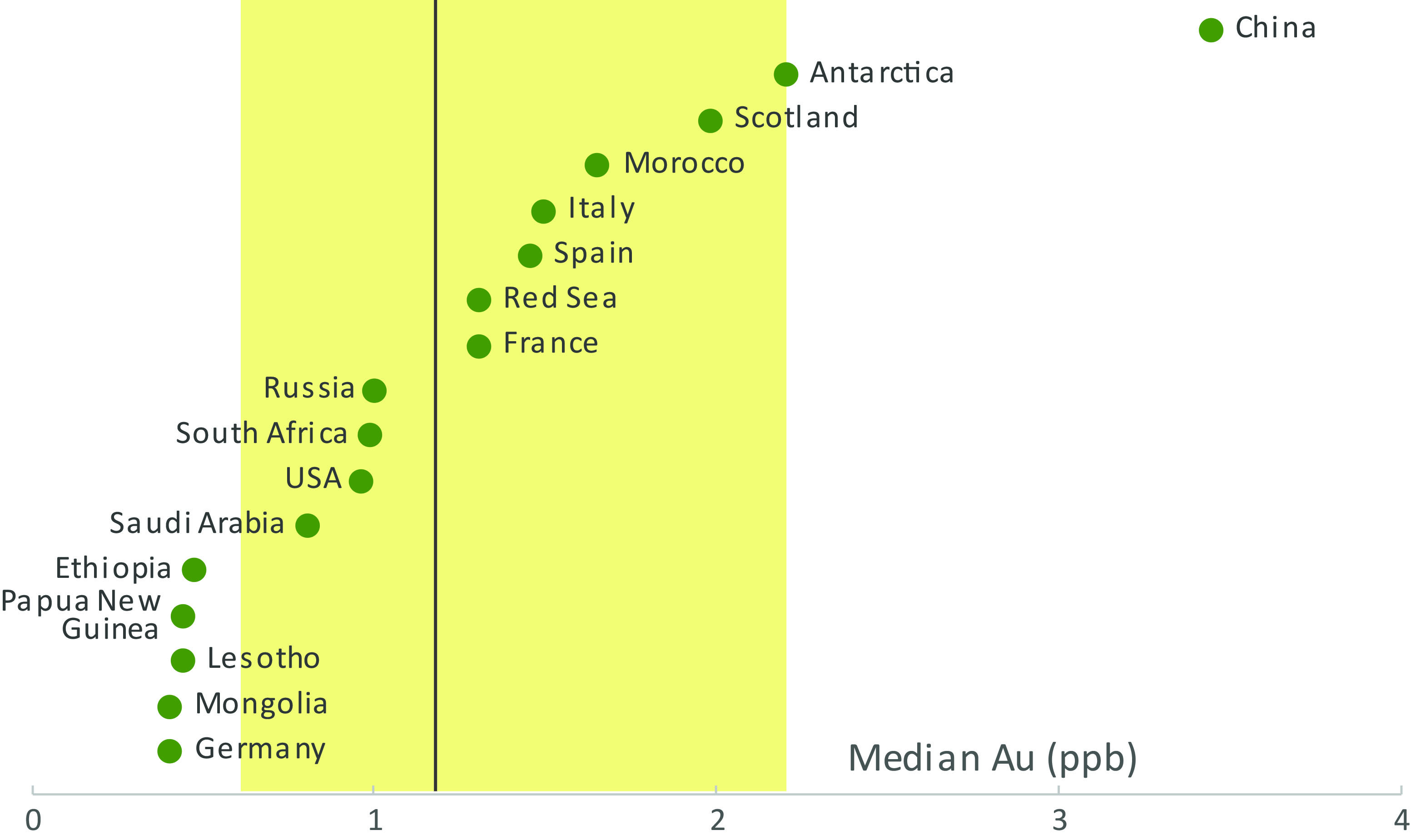
Figure 4. Median Au concentration in countries with five or more samples in the compiled database. Yellow box represents the 25-75th percentiles for upper mantle peridotites globally, dark grey line is median gold concentration for Au in upper mantle peridotites globally.

This project is part of CCFS themes 2 and 3, Earth’s Evolution and Earth Today, and contributes to understanding Earth’s Architecture and Fluid Fluxes.
Contacts: Ed Saunders, Sue O’Reilly, Bill Griffin
Funded by: TARDIS Flagship Program
Atmospheric sulfur is recycled into the continental crust during supercontinent formation
The sulfur cycle across the lithosphere and the role of this volatile element in the metasomatism of the mantle at ancient cratonic boundaries are poorly constrained. We address these knowledge gaps by tracking the journey of sulfur in the assembly of a Proterozoic supercontinent using mass independent isotope fractionation (MIF-S) as an indelible tracer. MIF-S is a signature that was imparted to supracrustal sulfur reservoirs before the ~2.4 Ga Great Oxidation Event. The spatial representation of multiple sulfur isotope data indicates that successive Proterozoic granitoid suites preserve Δ33S up to +0.8‰ in areas adjacent to Archean cratons. These results indicate that suturing of cratons began with devolatilisation of slab-derived sediments deep in the lithosphere. This process transferred atmospheric sulfur to a mantle source reservoir, which was tapped intermittently for over 300 million years of magmatism. Our work tracks pathways and storage of sulfur in the lithosphere at craton margins.
This project is part of CCFS themes 1 and 2, Early Earth and Earth’s Evolution, and contributes to understanding Earth’s Architecture and Fluid Fluxes.
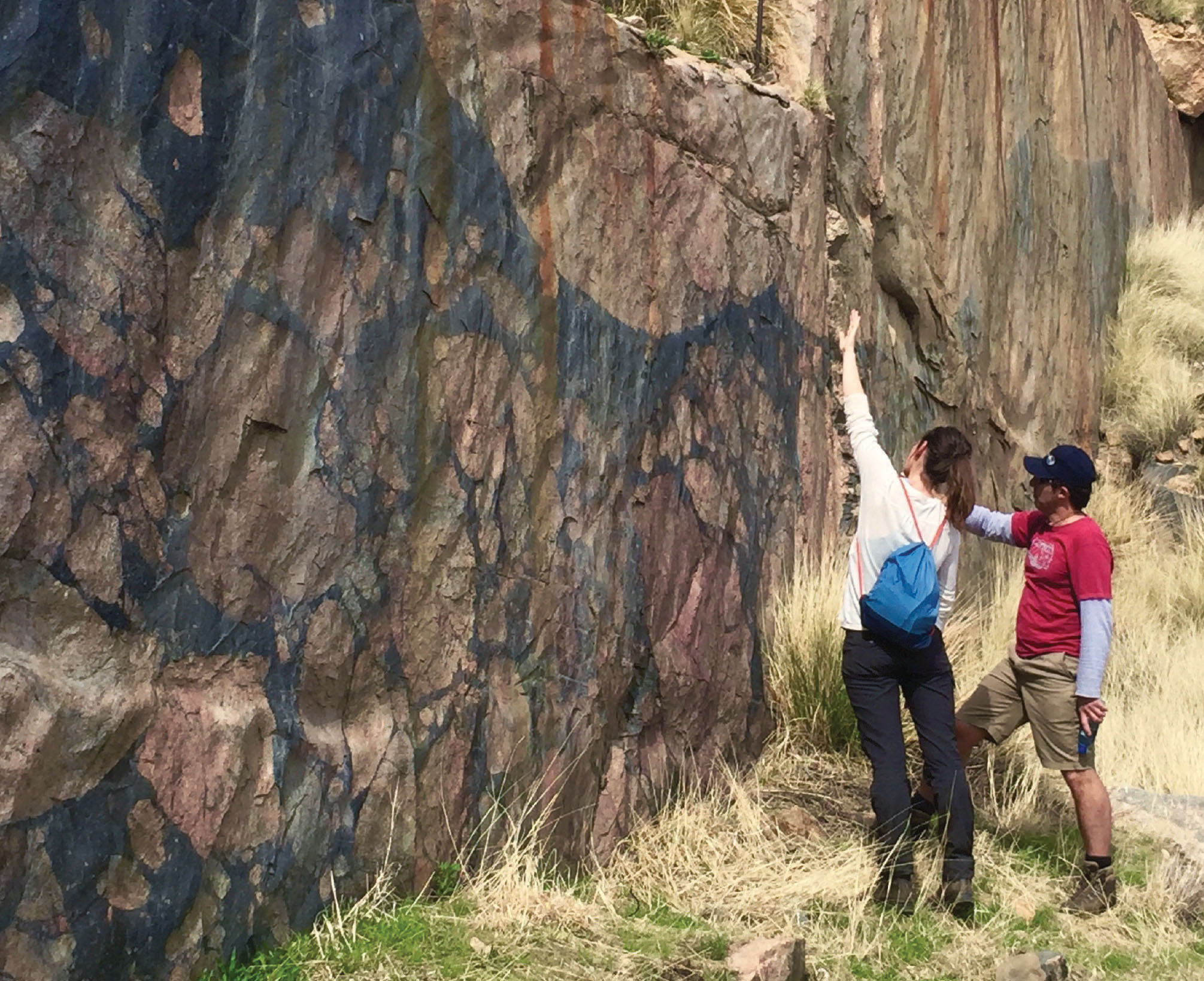
Figure 1. Crystal LaFlamme and Marco Fiorentini (UWA) try to unravel the cryptic link between the global sulfur cycle and the genesis of world-class mineral deposits.
Contacts: Marco Fiorentini, Crystal LaFlamme
Funded by: SIEF, MRIWA, CCFS Flagship Program 2
The curious story of the uniqueness of Archean lithospheric mantle in the Earth: Lithospheric mantle comes of age - dominant, persistent and widespread
Continental crust on the modern Earth is underlain by a subcontinental lithospheric mantle (SCLM), consisting dominantly of variably depleted ultramafic rocks. It ranges from a few tens of kilometres thick beneath active rift zones, to >250 km beneath some Archean cratons, and is represented as dismembered buoyant blobs in ocean basins following intracratonic rifting (CCFS publication #37). Archean SCLM is both more depleted, and much more widespread, than previously understood. Its generation led to the formation of buoyant (and hence unsubductable) continental nuclei, which influenced the preservation of early crust and the nature of early plate tectonics. Its persistence has provided important constraints on the mechanisms and extent of growth of SCLM, including precluding growth by subcretion of subducted oceanic crust (e.g. GEMOC publication #461). The composition of the SCLM has changed through time (CCFS publication #1183, Fig. 1): SCLM thick enough to permit the formation of diamonds may only have formed uniquely in Archean time, lurking beneath some cratons ever since.
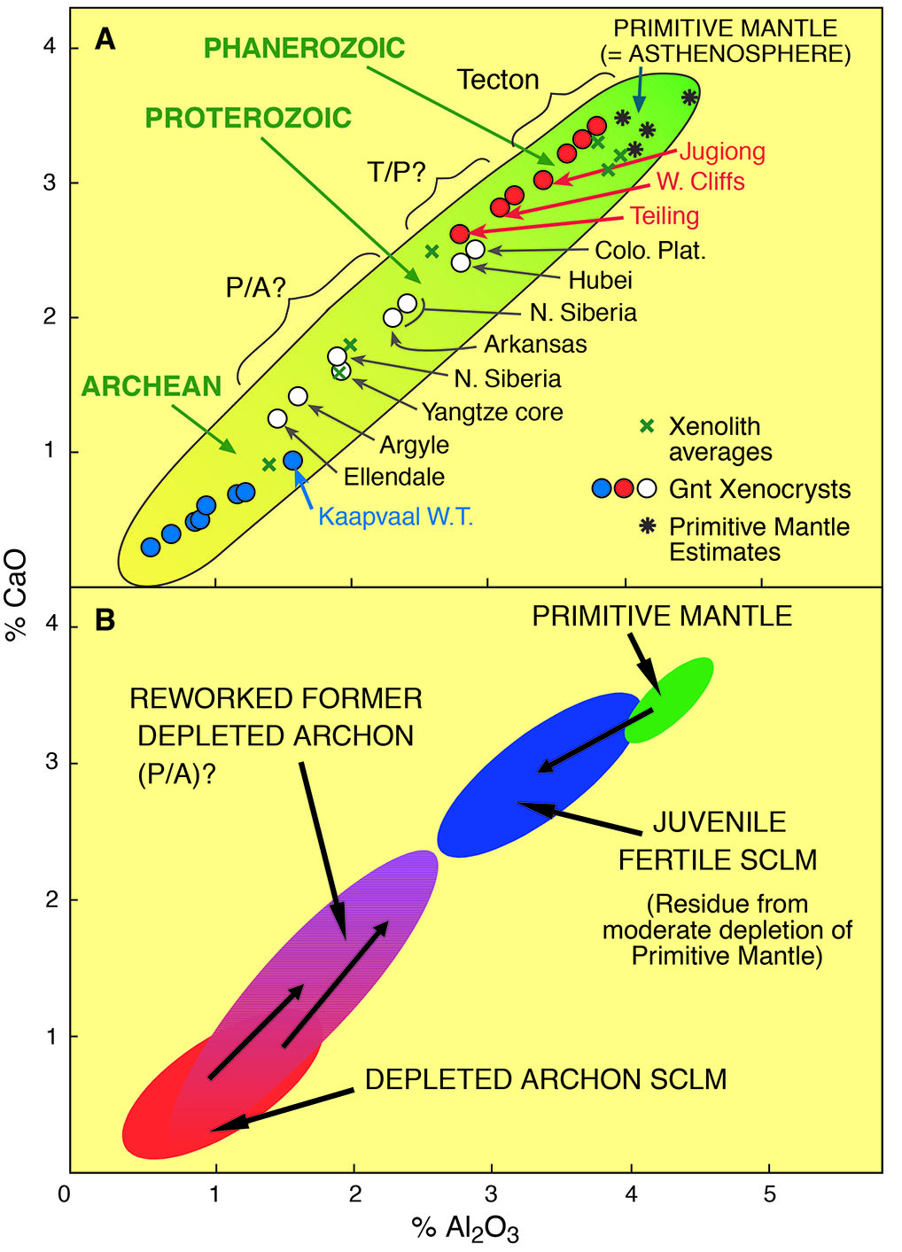
Figure 1. A. Estimates of the mean CaO and Al2O3 contents in subcontinental lithospheric mantle (SCLM) sections of different tectonothermal age based on the compositions of garnet xenocryst populations (circles) and xenolith populations (crosses) in volcanic rocks. B. Interpretation of the data in (A) in terms of depletion - refertilisation processes.
Archean SCLM is unique
The composition of the SCLM can be estimated from exposed orogenic massifs and from xenolith and xenocryst suites; each has its advantages and disadvantages. Most massifs represent relatively shallow SCLM sections, and have been strongly deformed during their emplacement, but exceptions may be found in some ultra-high-pressure zones, such as western Norway and in some orogenic domains in Tibet (CCFS publication #704). Xenolith suites sample larger vertical sections of the SCLM, but the relationships between different rock types are seldom obvious, and sampling (either by the volcano or by the geologist) may not be representative. Garnet xenocrysts in volcanic rocks can be used to estimate the composition of the SCLM, and this technique has provided a broader basis for mapping rock-type sections of the SCLM (CCFS publications #1, 299, 303).
How old is it?
The most robust isotopic system available for measuring the ages of SCLM peridotites is provided by the decay of 187Re to 187Os. During partial melting of the mantle, Re is extracted into the fluid phase, while Os remains concentrated in the residue; the removal of the melts from the system tends to freeze in the isotopic composition of the residual Os. The 187Os/188Os of the rock, or constituent minerals, can then be referred to a model for the evolution of Earth’s Re-Os system to derive a model age that approximates the timing of the melt-extraction event. Detailed sulfide Re-Os data show a general overall decrease in model ages with depth beneath at least the Kaapvaal craton, but old sulfides and younger ones coexist in single hand specimens, reflecting the injection of multiple generations of sulfide.
Although the in situ sulfide dating method has been applied to a large range of lithospheric samples from different Archean cratonic regions, very few reliable model ages older than 3.6 Ga have been found (CCFS publication #1183, Fig. 2.); and the same is true for whole-rock data. While we do not have xenoliths of the SCLM from beneath areas that contain Hadean crustal rocks, the apparent lack of Hadean model ages beneath the oldest cratons seems to indicate that there was no Hadean SCLM. If the SCLM that we see today came into being only in Archean time, what does this tell us about the evolution of the early Earth?
How did it form?
A common model used to explain the formation of Archean SCLM is by the accumulation of subducted slices of oceanic mantle (‘lithospheric stacking’). However, detailed seismic tomographic images of modern subducting slabs show that most descend steeply into the Earth, down to at least the 660 km discontinuity, rather than accumulating at shallow depths beneath the continents. In areas where shallow subduction is observed, the slab rarely extends far under the continents, and does not produce thick SCLM.
The composition of Archean SCLM as defined by xenolith suites is unique; the ‘pristine’ Archean SCLM is even more highly depleted than previous estimates and new values for the major oxides have been calculated (CCFS publication #1183). Thus, the formation of these highly depleted volumes appears to be related to specifically Archean processes, and are inferred to include megaplumes or massive mantle overturns (CCFS# 330; references therein). It is also unlikely to be coincidental that the production of highly depleted Archean SCLM coincides in time with the large-scale production of komatiitic magmas, which probably reflect high degrees of partial melting, requiring rapid decompression and leaving a highly depleted residue. Cogent evidence for the contribution of plumes to the ancient SCLM is provided by mineral inclusions in diamonds of minerals that are stable only under ultradeep lower-mantle conditions (e.g. ferropericlase, CaSi- and MgSi-perovskites).
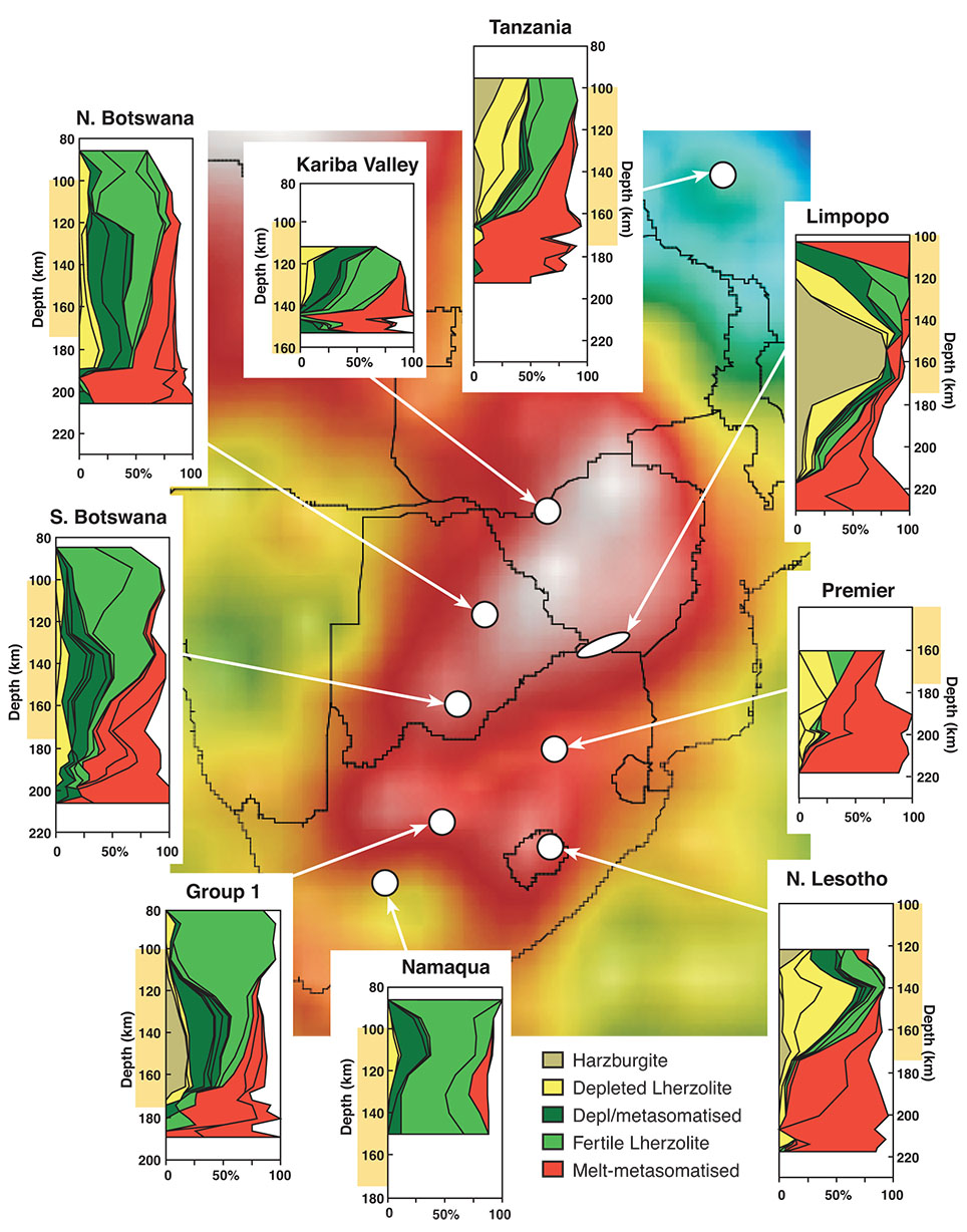
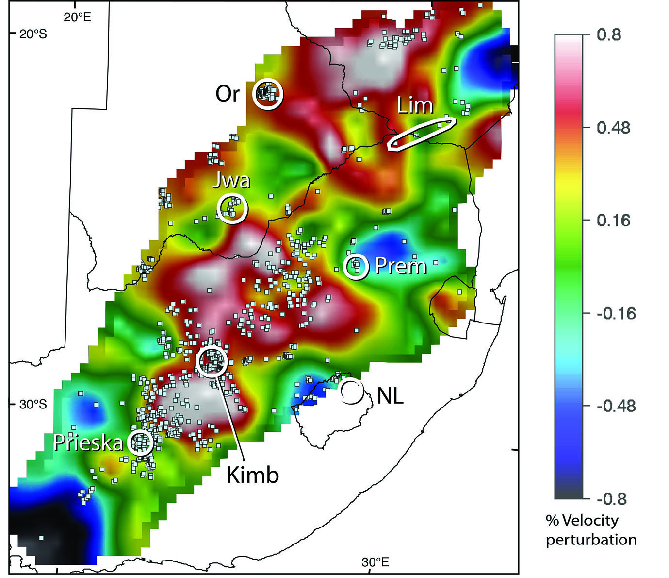
Figure 2. A. Seismic tomography image (100-175 km) of southern Africa, with location of well-documented xenolith suites and chemical tomography sections. White-pink colours indicate high seismic velocities, related to strong depletion and low geotherms; yellow-green colours indicate low velocities related to fertile compositions and higher geotherms. B. Detailed Vs tomography at 200 ± 50 km showing locations of known kimberlites. This emphasises that kimberlites tend to avoid blocks of best-preserved Archean subcontinental lithospheric mantle (white areas), instead following (and sampling) their more metasomatised, and hence lower-Vs, marginal zones. (Kimb, Kimberley area; NL, Northern Lesotho; Prem, Premier mine, Lim, Limpopo Belt; Jwa, Jwaneng; NB, Northern Botswana; Or, Orapa) (A) After Deen, T. et.al., 2006)., (B) After Fouch, M.J. et.al., 2004.
How extensive is Archean SCLM?
The Global Lithospheric Architecture Mapping (GLAM) project (GEMOC publications #547, CCFS publication #75) had produced maps of the rock types and ages of upper-lithosphere domains. These are blocks of crust and lithosphere generated or reworked at different times, and delineated by integrating regional tectonics and geochronology with all available geophysical data (magnetic, gravity, seismic) and geochemical datasets in a multi-dimensional database in a GIS environment (Fig. 3) The origins and evolution of the underlying lower-lithosphere domains are interpreted from a high-resolution global shear-wave tomographic model (CCFS publication #75), using thermal/compositional modelling (CCFS publications #217, 218) and xenolith/xenocryst data (compositions and ages) from volcanic rocks. This work has shown that most continents are assembled from Archean cratons and smaller cratonic fragments, stitched together and flanked by younger fold belts (e.g. GEMOC publication #547; CCFS publications #75, 1183). The larger cratons are underlain by geochemically depleted, buoyant and mechanically robust SCLM; these cratonic roots have steep sides, extending in some cases to more than 300 km.
The SCLM is not only widespread geographically beneath existing continents, but it also shows great vertical extent in at least some regions. High-resolution global seismic tomography (Vs) models reveal high-velocity domains beneath cratonic crust in Africa that extend to depths of 300-400 km (GEMOC publication #576). These high-velocity domains show a distinct contrast with the characteristics of ‘normal’ asthenosphere and are interpreted as depleted, buoyant roots that formed in the Archean and have remained attached to the overlying ancient crust. Archean lithospheric mantle has also been inferred beneath the Atlantic oceanic crust from tomographic models and the world magnetic-anomaly map (GEMOC #575; Korhonen et.al., 2007) confirms that continental roots, overlain by thinned continental crust, locally extend well out under the deep Atlantic Ocean basin. However, such high-velocity domains are not confined to the Atlantic basin margins, but are scattered randomly through other basins. These high-velocity domains are interpreted to be remnant buoyant ancient lithospheric fragments isolated by disruption of continental cratonic regions during rifting. This interpretation is supported by the old Os depletion ages of mantle peridotites from mid-ocean ridges and oceanic islands. (e.g. GEMOC publication #576; CCFS publication #1183).
This view of the secular evolution process emphasises the importance and uniqueness of the Archean SCLM. The formation of the Archean SCLM was one of the major events in Earth history, and the Paleoarchean-Mesoarchean period may have been a remarkable interregnum between the Hadean and a more modern Earth.
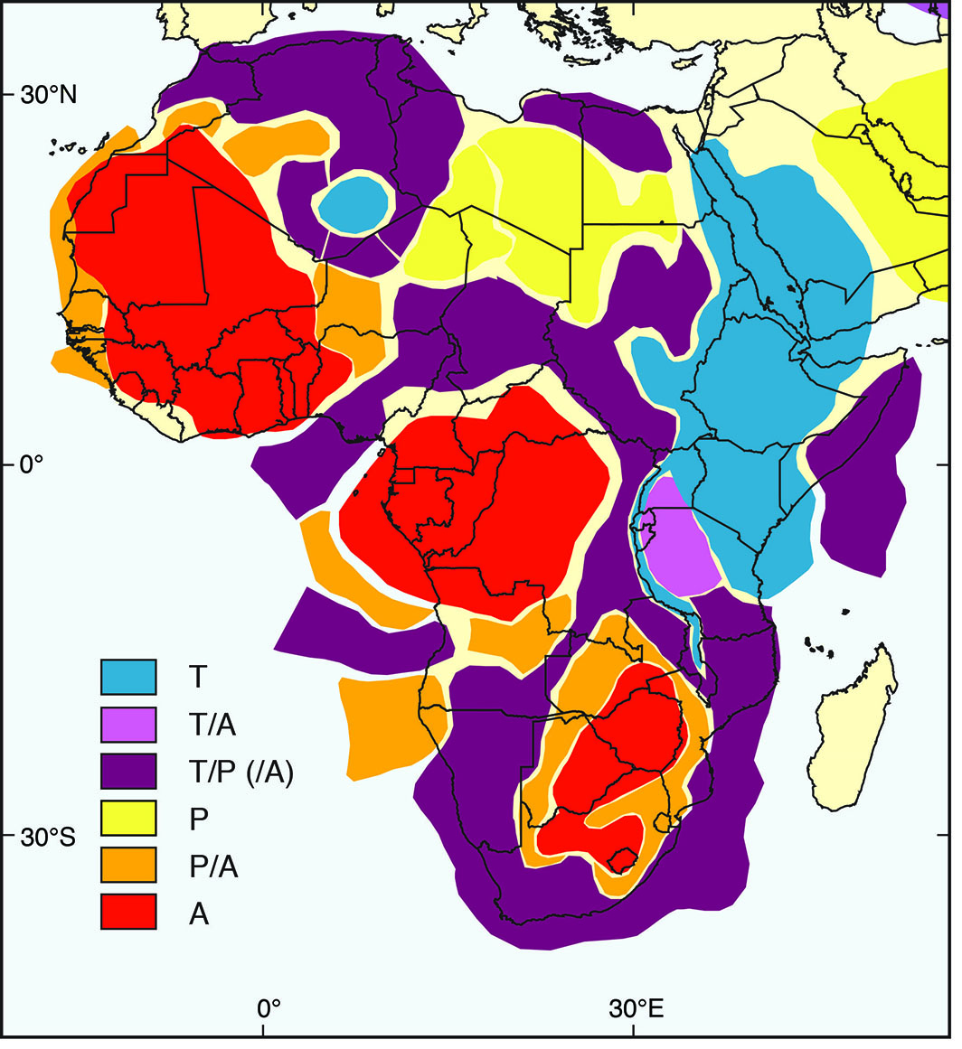
Figure 3. A Global Lithospheric Architecture Mapping interpretation of the subcontinental lithospheric mantle structure of Africa. A, Archon; P, Proton; T, Tecton (After Begg, et.al., 2009).
Implications for crustal evolution
If much of the present continental crust is underlain by SCLM produced in Archean time, then Archean crust may also be much more extensive than suggested by current outcrop patterns. Detailed studies of crustal xenoliths in basalts and kimberlites are now providing abundant evidence that ancient lower crust can be preserved while younger igneous rocks ‘resurfaced’ it to form the upper crust. Such areas include localities in the North China Craton (CCFS publication #95), the Mediterranean region (CCFS publication #234), Spitsbergen (CCFS publication #37) and the Yangtze Craton (CCFS publication #396).
Our estimates based on the GLAM methodology indicate that more than 70% of SCLM has Archean heritage: it underlies most younger continental crust, and even some oceanic crust.
These advances in understanding the timing and mechanisms of SCLM formation have implications for models of crustal growth and recycling through time, which remain to be explored.
This project is part of CCFS theme 2, Earth’s Evolution, and contributes to understanding Earth’s Architecture and Fluid Fluxes.
Contacts: Bill Griffin, Sue O’Reilly
Building the house from the basement: in situ isotopes in kimberlitic carbonates
Kimberlites are volcanic rocks, rich in volatiles (H2O and CO2), derived from a deep (>200 km) mantle source. As a consequence, they are often regarded as probes of the lithospheric mantle, providing unique insights of its structure, composition and evolution.
This project is focused on the study of primary kimberlitic carbonates, since they are considered good traps for the original CO2 in kimberlite magmas and thus the best minerals to constrain the C and O isotope composition of the kimberlite parental melts. However, initial petrographic and compositional studies of kimberlites worldwide emphasised the complex petrogenesis of kimberlitic carbonates, involving both syn- and post-emplacement processes (i.e. magma crystallisation, hydrothermal alteration, crustal contamination, degassing or weathering). This heterogeneous nature explains why C-O isotope analysis of bulk carbonates in kimberlites yield inconclusive results about their origin. It clearly was necessary to develop a new approach that could correctly identify the origins of the different generations of carbonates described in the kimberlites. For the first time, textural and compositional studies were combined with in situ isotopic techniques (SIMS) to accurately measure the Sr, C and O isotope compositions of both primary and secondary carbonates.
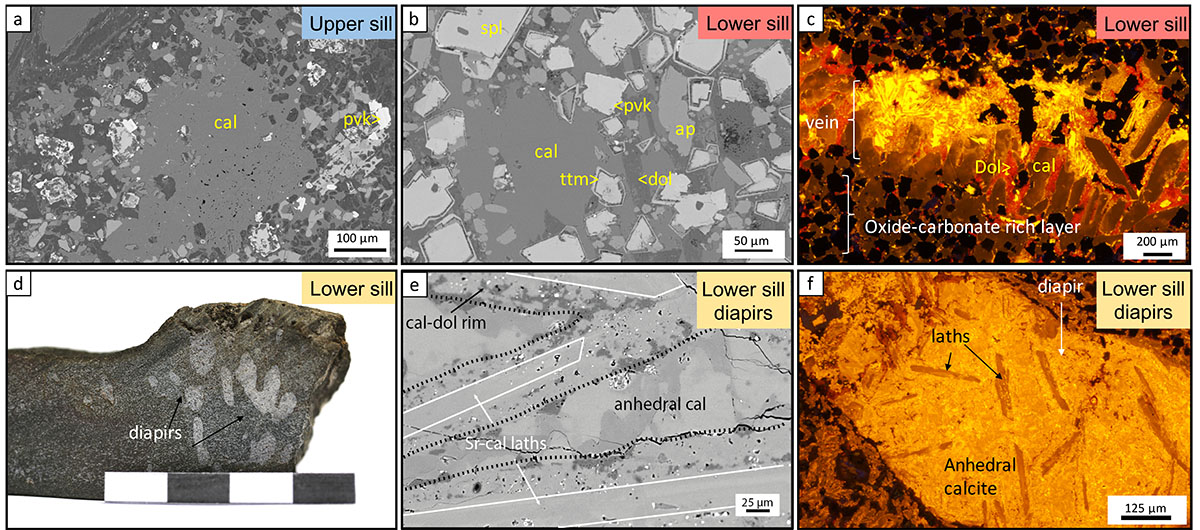
Figure 1. Carbonate petrography of the upper and lower sills in Benfontein. A) BSE-SEM image of the groundmass calcite (cal), interstitial to serpentinised olivine, with groundmass spinel and perovskite (pvk). B) BSE-SEM image of the oxide-rich layer, with abundant atoll spinel (spl) with a titanomagnetite rim (ttm), apatite (ap) and perovskite, with interstitial calcite and dolomite (dol). C) Cathodoluminescence (CL) image of the oxide-rich layer of the lower sill, crosscut by a carbonate-rich vein. (D-F) Hand sample, BSE-SEM and CL images of the diapirs of the lower sill. Note the different generations of carbonates: Sr-rich calcite laths, pure anhedral calcite of most of the diapir and a calcite-dolomite reaction rim.
A good example of the potential of this integrated methodology can be seen in our recent characterisation of the Benfontein kimberlite sills (South Africa). These three sills are well-known for their enrichment in carbonates, which show a variety of textures and compositions (e.g. laths, interstitial groundmass, veins) (Fig. 1 a-c). Another characteristic feature of the Benfontein kimberlite is the presence of calcite blobs or ‘diapirs’ intruding the uppermost layers of the lowest of the three sills (Fig. 1 d-f). The origin of carbonate-rich sills associated with kimberlites has been a matter of debate since their discovery, and there is still no consensus about the origin of the ‘diapirs’ at Benfontein. They have been related to carbonate-rich melt segregations from an evolved kimberlite magma; infilling of early gas cavities with a residual kimberlitic fluid; or crystallisation from hydrothermal, crustal-contaminated fluids.
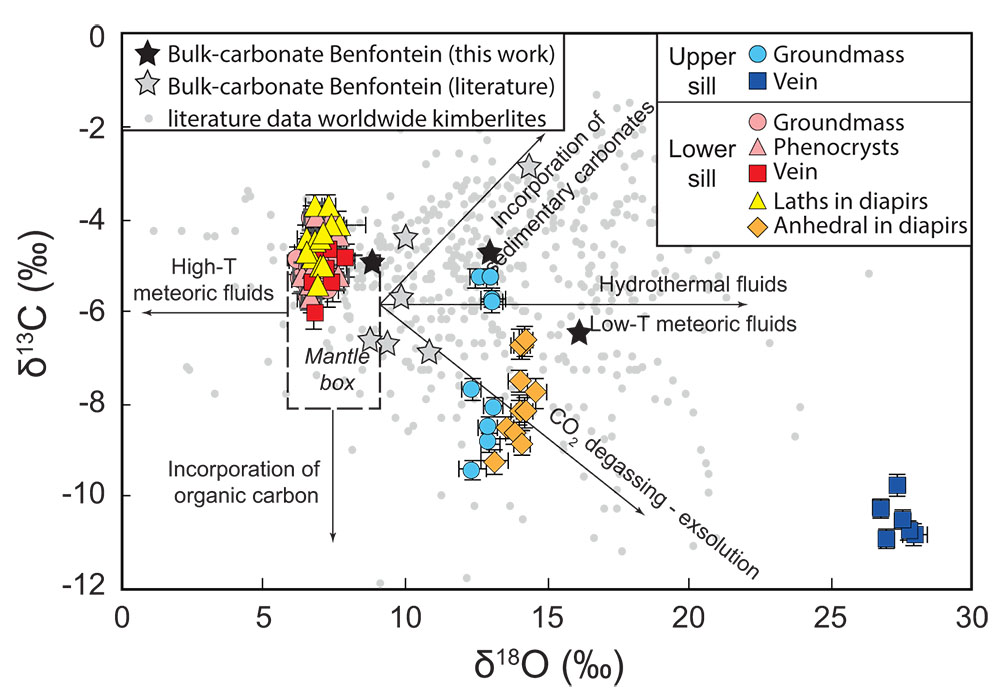
Figure 2. Plot of δ13C (relative to VPDB) versus δ18O (relative to VSMOW) showing the isotopic composition of different textural types of calcite from the Benfontein kimberlite analysed in situ by SIMS. Note that calcite in the groundmass, veins and diapirs (laths only) from the Lower sill plot in the “mantle box”. Qualitative trends show how syn- and post-magmatic processes would modify the C-O isotope composition of magmatic carbonates.
Our multidisciplinary approach not only revealed the petrographic and geochemical complexity of carbonates in kimberlites in unprecedented detail, but also allowed confident identification of the processes that led to their formation. As shown in Figure 2, in situ C-O isotope studies, combined with Sr isotope analysis, have identified carbonates derived from:
i. magmatic crystallisation of Sr-rich calcite laths and groundmass; ii. crystallisation of late groundmass calcite from hydrothermal fluids; and iii. variable degrees of crustal contamination in carbonate-rich diapirs and secondary veins. These diapirs most likely resulted from a residual C-O-H fluid or carbonate melt that had interacted with the local Dwyka shales, leading to higher 87Sr/86Sr and δ18O, but lower δ13C, than pristine magmatic calcite. Before coalescing into the diapiric segregations, they also variably entrained early-formed calcite laths and groundmass phases.
Comparison between in situ and bulk carbonate analyses (Fig. 2) confirms that C-O isotopic analyses of bulk carbonates from kimberlite rocks are not representative of the original C-O isotopic signature of the kimberlite magma. In contrast, calcite laths and most groundmass grains at Benfontein preserve isotopic values (δ18O = 6 to 8‰ and δ13C = -4 to -6 ‰), similar to those of pristine carbonatites, which therefore probably correspond to those of their parental melts. This narrow range suggests that the “mantle carbonate” box in Figure 2 could be more restricted than previously proposed.

This project is part of CCFS themes 1 and 2, Early Earth and Earth Evolution, and contributes to understanding Earth’s Fluids.
Contacts: Montgarri Castillo-Oliver, Andrea Giuliani, Bill Griffin, Sue O’Reilly, Russell Drysdale, Adam Abersteiner, Emilie Thomassot, Xian-Hua Li
Funded by: CCFS Flagship Program 1, ARC DECRA to Andrea Giuliani (grant DE-150100009, European Science Foundation: Europlanet 2020 Consortium (project n. 16-EPN2-017)
The physics of recent earthquakes in southwest WA
On September 16, 2018, a magnitude 5.7 earthquake occurred near Lake Muir in southwestern Western Australia. The epicenter of the earthquake is located at the southwest corner of the SW Seismic Zone (Geoscience Australia 2018), where no quakes over magnitude 5 have ever been recorded before. After the mainshock, a sequence of aftershocks were recorded by the sparse regional seismic network. Obtaining reliable moment tensor solutions is important for revealing the seismogenic zones of the Lake Muir earthquake cluster, and to better understand the regional stress field that is important in regional hazard assessment.
In this study, we used a time-domain linear least-squares inversion method (Lin et al. Tectonics 2018; CCFS contribution #1109) to analyse the moment tensors of Lake Muir earthquakes and earlier regional earthquakes. Compared with other methods, this wave-form-based technique has a better control on the source parameters. We used long-period waveforms between 20 and 50 seconds, in the moment tensor inversion. For the smaller earthquakes or the noise waveforms, we also considered the long-period waveforms between 14.3 and 25 seconds or 10 and 25 seconds.
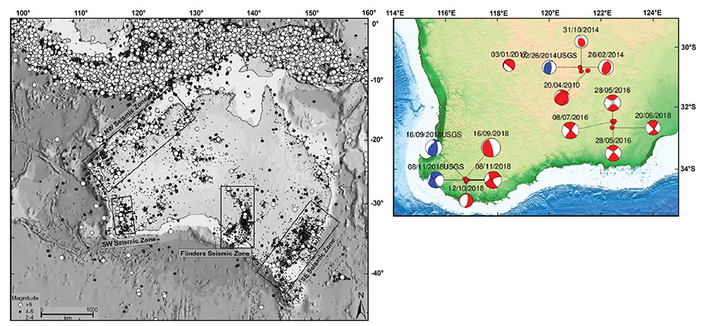
Figure 1. Seismic Zones of Australia (left; Rajabi et al., Earth-Science Reviews 2017) and Moment tensor solutions of earthquakes in SW Western Australia (right) obtained from this study (red beachballs). The M5.7 Lake Muir Earthquake occurred on Sept 16, 2017. Three solutions from the USGS (blue) are plotted for comparison.
An important aspect in source-mechanism inversions is to have robust P- and S-wave velocity models. Taking advantage of the location of the Muir Earthquake being close to a permanent seismic station (RKGY), we constructed the S-wave velocity models by applying a transdimensional tomographic inversion technique (Yuan and Bodin, Tectonics 2018; CCFS Contribution 1181) to the dispersion datasets measured from station pairs between RKGY and other permanent stations. The P-wave model is approximated by using an active source reflection profile (Dentith, Tectonophysics 2000).
The solutions of the M5.7 Lake Muir earthquake and its M5.4 aftershock are shown in Figure 2 below. It is interesting is that the M5.7 main shock on Sept 16 (Fig. 2 left) shows mainly a thrust mechanism, but the two aftershocks, each occurring nearly a month apart on Oct 12 (M4.6) and Nov 08 (M5.4; righthand side in Fig. 2), show a gradual change in the solution towards strike-slip. We also inverted for source mechanisms for several recent earthquakes in southwestern WA. Some solutions were compared with that by the USGS (Fig. 1) which show consistent results.
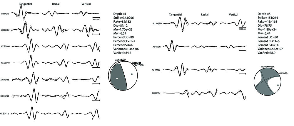
Figure 2. Source mechanism inversions for the M5.8 main shock (left) and the M5.4 aftershock (right) of the Lake Muir earthquake sequence.
The regional stress field indicates an east-west compression (Rajabi et al., Earth-Science Reviews 2017), which explains the thrust-type mechanism of the M5.7 main shock, as well as of those earthquakes within the Yilgarn craton in the Kalgoorlie region. The change of the source mechanisms in the Lake Muir aftershocks may be attributed to a combined effect of complex stress release of the main shock in the complex local fault systems and triggering of new faults due to stress release of the main shock. Similar strike-slip solutions are found further east along the NE-SW trending craton margin in the east Albany-Fraser zone.
This project is part of CCFS theme 3, Earth Today, and contributes to understanding Earth’s Architecture.
Contacts: Dr Xiangdong Lin (Beijing Earthquake Agency - visit sponsored by CCFS (2017-2018)) Huaiyu Yuan, Mike Dentith (GSWA), Ruth Murdie (GSWA), and Klaus Gessner (CCFS, GSWA)
Funded by: CCFS Flagship Program 7
CO2 degassing - a new model approach to melting of mantle lithosphere
Reactivation of metasomatised mantle lithosphere may occur during continental extension, which is an important component of plate tectonics. The lower-most part of the metasomatised domains in the subcontinental mantle lithosphere can be locally enriched in CO2. Therefore, partial melting of these metasomatised domains may play a crucial role in the global carbon cycle. However, little is known about this process and up until now few numerical constraints are available. Here we address this knowledge gap and use a 2-D high resolution petrological-thermomechanical model to assess lithospheric rifting, CO2 degassing and melting. The numerical models fit well into natural rifting zones of the European Cenozoic Rift System for young (shallow) and of the North Atlantic Rift for old (thick) lithosphere.
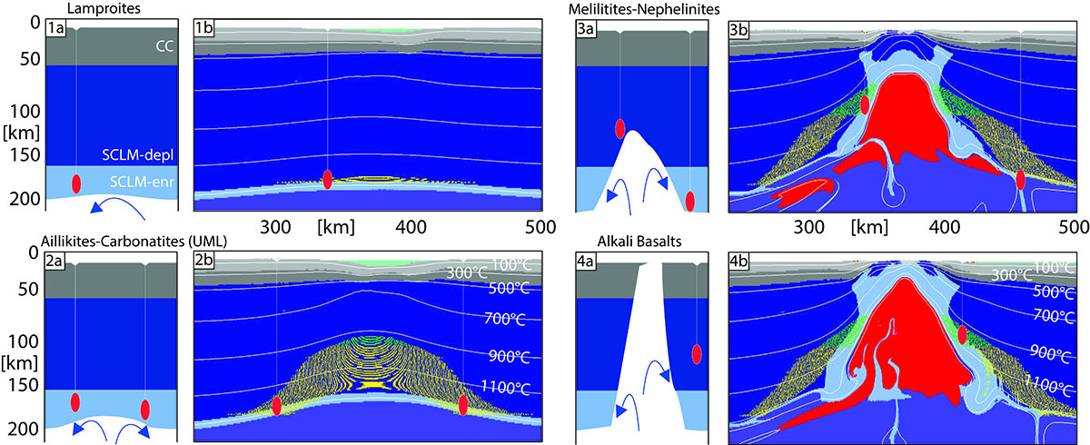
Figure 1. Comparison of tectonomagmatic model (plates [a]) of a segment of North Atlantic Craton close to the southern craton margin modified after Tappe et al. (2007), to numeral model 200 (plates [b]). Abbreviations: cc - continental crust, SCLM-depl - subcontinental lithospheric mantle - depleted, SCLM-enr - subcontinental lithospheric mantle - enriched in CO2.
This project is part of CCFS theme 2, Earth’s Evolution, and contributes to understanding Earth’s Architecture and Fluid Fluxes.
Contacts: Weronika Gorczyk, Christopher Gonzalez
Funded by: CCFS Flagship 2
Olivine grains - new clues to the origin of diamondiferous kimberlites
Kimberlites are small-volume igneous rocks that have a unique role in the Earth sciences because they represent the primary host of diamond deposits; and derive from the deepest melts that occur at the surface of our planet. Despite decades of dedicated studies, the petrogenesis of kimberlites remains not fully understood. This is largely due to the complex hybrid nature of these rocks, including magmatic as well as abundant xenocrystic and alteration components. Olivine can provide unique insights into kimberlite origin and evolution, because it is the most abundant xenocrystic phase and a stable magmatic product over most of the crystallisation history of these magmas. Most olivine grains in kimberlites are compositionally zoned regardless of size and shape (Fig. 1). The zonation typically includes a core of variable composition that is overgrown by a rim characterised by relatively restricted Mg contents (Fig. 3), lower Ni and Cr, and higher Mn, Ca and Ti contents. One or more internal zones of variable composition may occur between core and rim of some grains (Fig. 1). The internal zones may be euhedral, diffuse or partially resorbed (embayments).
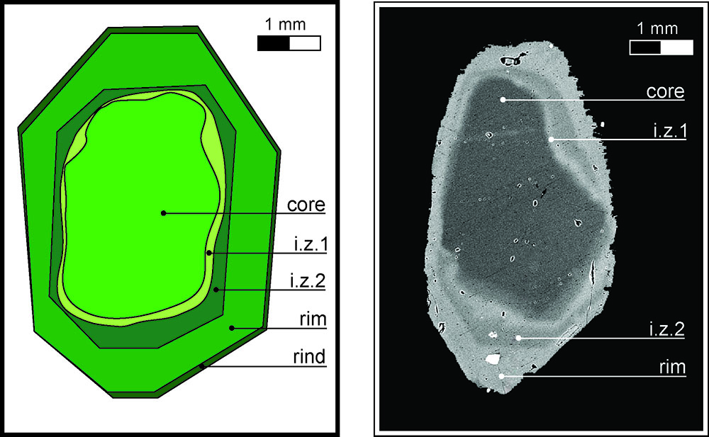
Figure 1. Cartoon showing the compositional zoning of an idealised olivine phenocryst, compared to a SEM back-scattered electron (BSE) image of a complexly zoned phenocryst from the Udachnaya-East kimberlite (Siberia).
A comparison between the compositions of olivine cores and olivine from mantle xenoliths (including megacrysts) entrained in kimberlites (Fig. 2), demonstrates that olivine cores are xenocrysts derived from disaggregation of mantle wall-rocks. This interpretation is consistent with the occurrence of mantle phases (i.e. orthopyroxene, clinopyroxene, garnet and Cr-spinel) as inclusions in olivine cores, and evidence of resorption (embayments) and abrasion (rounded shapes) of these cores. A variable proportion of olivine cores is sourced from mantle wall-rocks previously metasomatised kimberlitic magmas at mantle depths (including sheared peridotites and megacrysts), implying variable degrees of kimberlitic magma activity in the mantle before current kimberlite emplacement at surface.
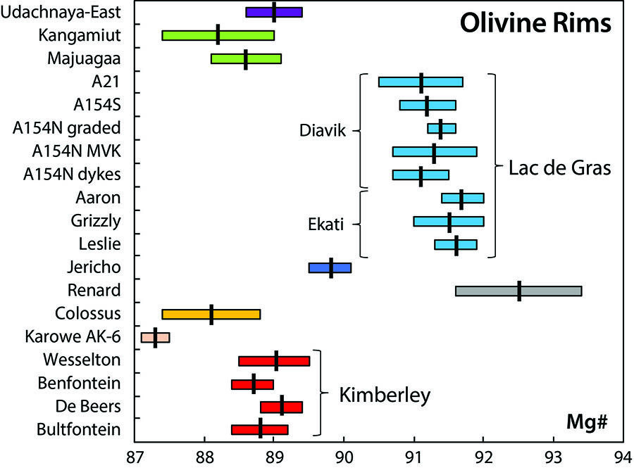
Figure 2. Mg#-NiO covariation diagram comparing the compositions of olivine cores in kimberlites with those of olivine in mantle lithologies sampled by kimberlite magmas, including megacrysts and peridotite xenoliths.
Olivine rims host inclusions of groundmass minerals (e.g. spinel, Mg-ilmenite, rutile), requiring a magmatic origin for the rims. There is a direct correlation between olivine rim and groundmass composition: high Mg/Fe rims are associated with carbonate-rich kimberlites, and lower Mg/Fe rims are correlated with increased phlogopite and Fe-bearing oxide modes (Fig. 4). With few exceptions, the compositions of olivine rims in each kimberlite locality, cluster (e.g. Kimberley) or form a compositional trend (e.g. Lac de Gras) within a restricted Mg# range (Fig. 3). This suggests that kimberlites within the same cluster derive from similar parental melts (and therefore sources), consistent with available radiogenic isotope results. Olivine rims in kimberlites from Lac de Gras, are compositionally indistinguishable from those occurring in rocks in hypabyssal root-zones, dykes and volcaniclastic units, thus indicating that such olivine crystallised during ascent, before different emplacement processes modified magma compositions. It can thus be inferred that the composition of (near-primitive) melt parental to olivine has minimal influence on kimberlite emplacement mechanism. Variations in the compositions of olivine rims in kimberlites from different areas relate to different parental melt compositions and contributions from a range of local processes (e.g. including olivine and spinel fractionation, assimilation of mantle material, CO2 loss, melt oxidation) rather than variations in tectonic setting or emplacement mechanism.
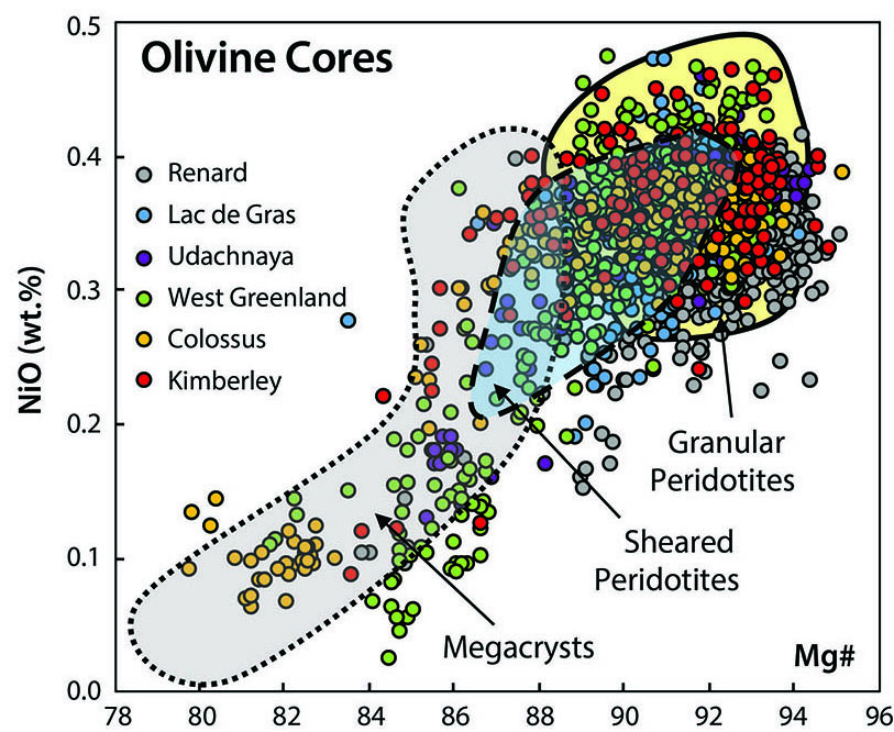
Figure 3. Average Mg# (± 2 s.d.) values of olivine rims in kimberlites worldwide. Note the similar compositions of rims within the same kimberlite cluster (i.e. Kimberley) and field (i.e. Lac de Gras).
Based on their compositional and textural features, three types of internal zones can be distinguished: 1) euhedral early liquidus olivine with higher Mg# and Ni than rims and hosting inclusions of magmatic chromite; 2) diffusional zones with compositions intermediate between those of cores and rims; 3) zones exhibiting resorption features that may be products of earlier kimberlite metasomatism at mantle depths.
In summary, olivine exhibits broadly analogous zoning in kimberlites worldwide. Olivine grains represent unique capsules that provide a potentially complete record of the evolution of kimberlite systems. Olivine cores store information on material entrained by kimberlites from the traversed mantle column, including evidence for early kimberlite metasomatism. Internal zones can show the effects of mantle metasomatism and/or record early kimberlite crystallisation at mantle depths. Rim compositions testify to the complex interplay of different processes during ascent and emplacement of kimberlite magmas. Ongoing research is exploring potential links between mantle-xenocrystic core and magmatic rim compositions to understand the effect of assimilation of mantle material on kimberlite melt composition; the oxygen isotopic composition of olivine to constrain the potential occurrence of recycled crustal material in the source of kimberlites; and the variability of olivine composition with time within kimberlite provinces to decipher the sources and evolution of different kimberlitic magma batches during protracted (10-30 Myr) magmatic episodes.
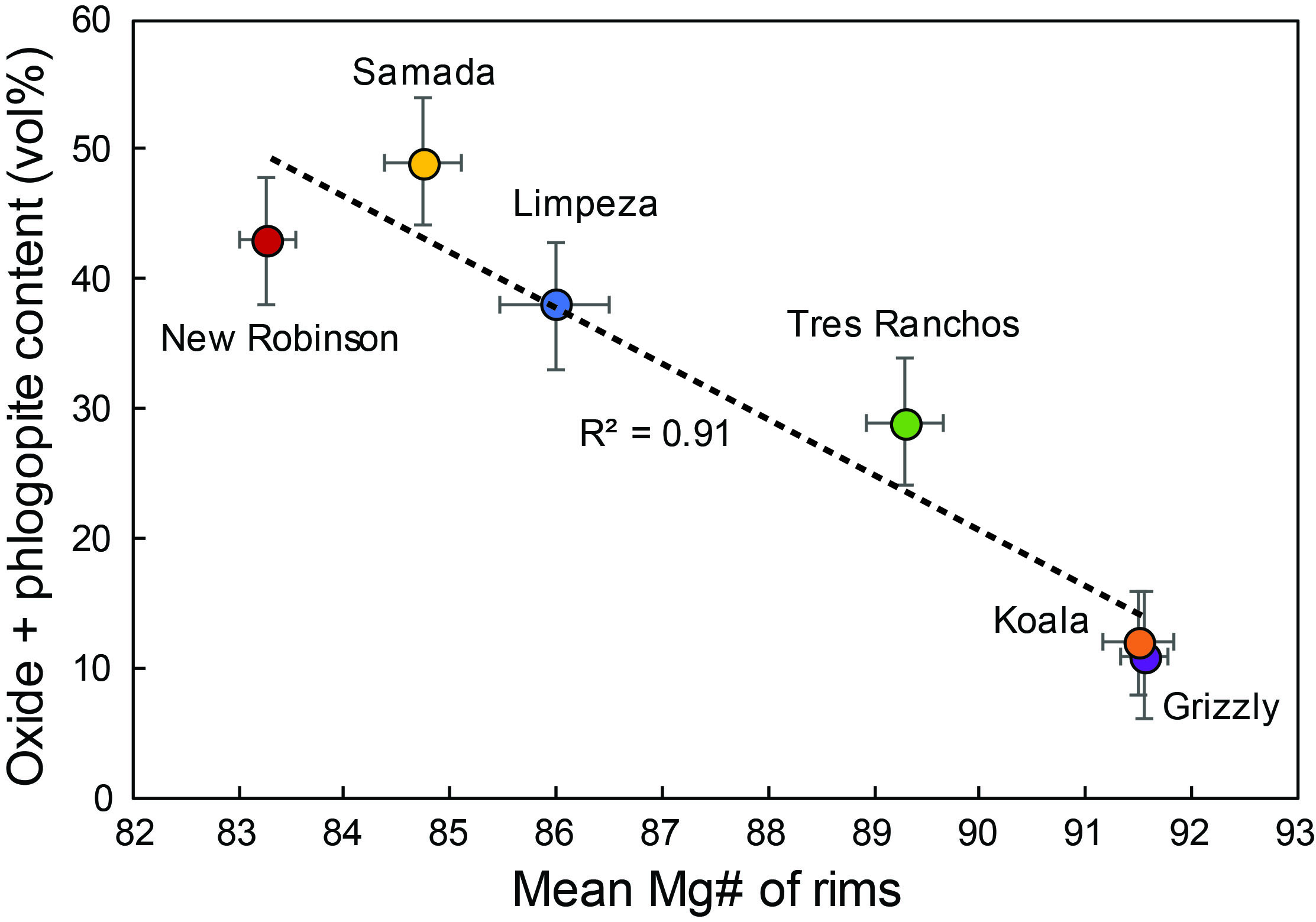
Figure 4. Comparison of mean Mg# value of olivine rims with the estimated abundance of phlogopite plus oxide minerals (spinel + Mg-ilmenite + perovskite) in the groundmass of kimberlites examined in this study. Note the statistical robustness of the inverse correlation between the two parameters (after Lim et al., 2018 Mineral Petrol).
This project is part of CCFS theme 2, Earth’s Evolution, and contributes to understanding Earth’s Fluid Fluxes.
Contact: Andrea Giuliani
Funded by: ARC DECRA
Micro to global: microstructures reveal mantle secrets beneath the Pannonian Basin, Central Europe
Microstructures of mantle xenoliths can reveal the nature and behaviour of the upper mantle during tectonic processes.
The characteristics of mantle-rock deformation are imprinted on the silicate minerals of the xenoliths, potentially identifying the tectonic history, as well as variables such as temperature, pressure, H (“water”) content, and/or the interaction with melts/fluids. Physical properties of olivine, the most abundant upper mantle mineral, can be a proxy for the deformation processes that affected the xenolith-sampled mantle domain. Such parameters include orientation patterns of crystal axes, the strength of fabric expressed by the J-index (a dimensionless value that is a measure of the fabric strength, ranging from 1 (random orientation distribution) to infinity), and the grain orientation spread (a measure of the average amount of intragranular deformation).
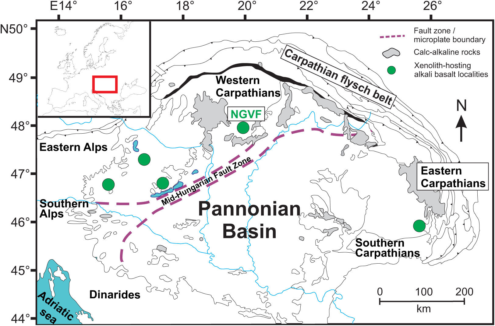
Figure 1. Locations of mantle xenolith-hosting alkali basalt outcrops within the Carpathian-Pannonian region. NGVF - Nógrád-Gömör Volcanic Field.
The Pannonian Basin is a young back-arc basin located in Central Europe, surrounded by the Alps, Carpathians and Dinarides (Fig. 1). It has undergone significant extension during the Miocene then a compressional phase from ~8 Ma to recent times, resulting from the convergence of Adria and the European platform. Mantle-derived xenoliths were brought to the surface by late Miocene-Pleistocene alkali basalts in five areas (Fig. 1). The focus of this study is the xenoliths from the northernmost locality, the Nógrád-Gömör Volcanic Field, where crystal preferred orientations have not previously been described.
The xenoliths were analysed with a polarisation microscope and electron backscatter diffraction technique. Microstructural features indicating deformation include lineation outlined by spinel distribution (Fig. 2a) and elongated grain shapes, as well as common subgrain boundaries (seen as undulose extinction (Fig. 2b)). These deformation markers are commonly overprinted by annealing (static recrystallisation) resulting in grain growth of olivine (where olivine is not pinned by pyroxenes (Fig. 2c)), and straight grain boundaries with 120° triple junctions (Fig. 2d). Crystal preferred orientations of olivine reveal that most orientation patterns indicate deformation in a transpressional regime. This is consistent with the stress field generated by the convergent tectonics between the Adria microplate and the European platform.
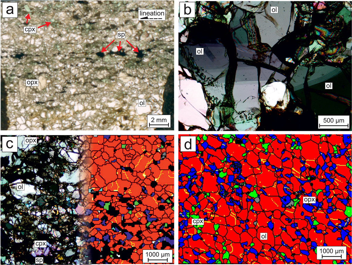
Figure 2. Characteristic microstructures in the studied Nógrád-Gömör xenoliths. a - lineation indicated by the distribution of spinel grains; b - subgrain boundaries in olivine; c - different olivine grain sizes in pyroxene-rich and pyroxene-poor domains; microphotograph (left) and electron backscattered diffraction (EBSD) phase map (right); d - EBSD map of equilibrated texture (straight grain boundaries, 120° triple junctions). Photomicrographs are transmitted light, plane-polarised in a, and cross-polarised in b and c. Colours on EBSD phase maps: red - olivine, dark blue - orthopyroxene, green - clinopyroxene, grey - spinel, light blue - amphibole. Abbreviations: ol - olivine, opx - orthopyroxene, cpx - clinopyroxene, sp - spinel.
Based on the positive correlation between the J-index and the equilibration temperatures (Fig. 3a) calculated from mineral compositions (Liptai et al., 2017, J. Pet.; CCFS publication #1004), the extent of deformation varies with depth. In addition, the extent of intragranular deformation is more dependent on the location, as it decreases from the northern part of the volcanic field towards the south (Fig. 3b). Post-kinematic annealing is linked to percolation of metasomatic mafic melts in the upper mantle of the NGVF before eruption of the host alkali basalt. Elevated equilibration temperatures in xenoliths from the central part of the volcanic field (Fig. 3b) are interpreted to derive from the youngest metasomatic event, which only shortly preceded the ascent of the host magma.
Crystal preferred orientation data also allow the calculation of seismic properties; combining that with measured shear wave splitting times in the area, the thickness of the anisotropic layer was estimated. The anisotropic thickness depends on the orientation of the foliation and lineation. The preferred model, on the available data, is horizontal lineation and vertical foliation. This is consistent with the recent tectonic regime, and also gives a minimum value for the thickness of the anisotropic layer. Some asthenospheric contribution may be needed to produce the observed shear wave splitting.
Figure 3. Olivine deformation features compared to calculated equilibration temperature (Ca-in-opx thermometer after Nimis & Grütter, 2010, CMP).
This project is part of CCFS theme 2, Earth’s Evolution, and contributes to understanding Earth’s Architecture.
Contacts: Nora Liptai, Sue O’Reilly, Bill Griffin, Csaba Szabó (Eötvös University, Hungary), Károly Hidas (University of Granada, Spain), Andréa Tommasi (University of Montpellier II, France)
Funded by: CCFS Flagship Program 1, iMQRES scholarship, EPS postgraduate funds. This project is part of a cotutelle PhD program between Macquarie University and Eötvös University, Budapest, Hungary.
A giant step towards a unified model for mantle magmatism
Mantle magmatism is a consequence of thermal discontinuities in, and one of the main mechanisms for the thermal evolution of, the Earth and other terrestrial planets. Encompassing partial melting, melt migration and mixing, melt-rock interaction and crystallisation, mantle magmatism can be modelled as a combination of phase changes (e.g. from solid to liquid), differential flow (e.g. of a fluid through a rigid matrix) and chemical reactions (exchange of chemical components). It can be described as a Muliti-Phase, Multi-Component, Reactive Transport system (MPMCRT) that can, in principle, be constrained experimentally and numerically modelled.
Over the past four decades specific aspects of MPMCRT, in the context of mantle magmatism, have been independently addressed by different communities (including petrologists, geochemists, geophysicists, computational geodynamicists). A new conceptual and numerical approach, integrating petrological, geochemical and geophysical considerations into a fully quantitative and comprehensive approach to mantle magmatism, bridges these traditional research silos.
This approach combines (1) a microstructural model for diffusion-controlled trace-element transport and (2) disequilibrium extensions of the multi-phase reactive transport model developed by Oliveira et al. (2018) (CCFS Publication #1012).
In particular, chemical disequilibrium is accounted for by the novel thermodynamic formalism Dynamic Disequilibrium Melting (DDM, Fig. 1). DDM provides a versatile platform, not only able to study the dynamics and feedback of many magmatic systems over multiple scales but also rendering possible realistic comparisons between geophysical and geochemical datasets.
For example, the results of our MPMCRT model of mid-ocean ridges suggest that the modal, major- and trace-element compositions of abyssal peridotites could solely be accounted for by melt-extraction processes if disequilibria arising from transport, phase changes and diffusion (Fig. 2) are accounted for. Similarly, local and global trends in MORB compositions could be reproduced using self-consistent tectonic scenarios. Application to lithospheric refertilisation processes is also particularly promising by introducing the properties for radiogenic isotope systems (currently under development).
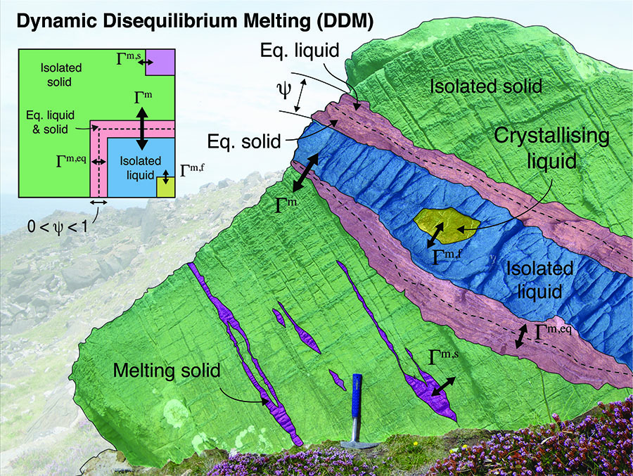
Figure 1. Schematic illustration (a) and projection (b) of the Dynamic Disequilibrium Melting model on a virtual outcrop of mantle rocks. Pink areas refer to fully equilibrated regions (e.g. dunitic reaction zone) and green and blue refer to chemically isolated solid (e.g. harzburgite) and liquid (e.g. basaltic melt), respectively. Each of the three regions has its own set of P-T-cb conditions, and thus individual Gibbs free-energy minimisations are possible, allowing for independent crystallisation (yellow areas) and/or melting (purple areas) in the liquid and solid regions, respectively.
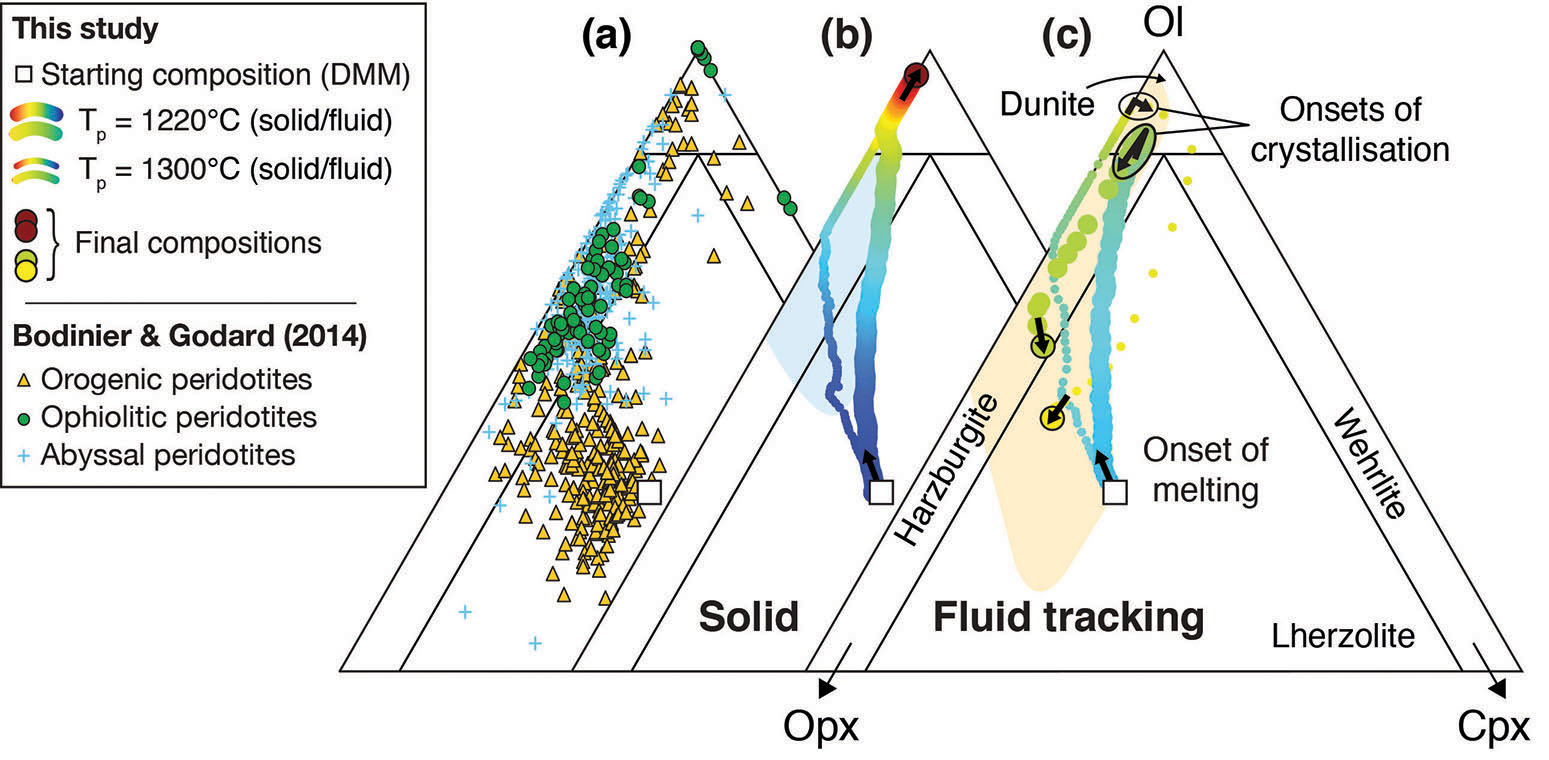
Figure 2. Comparison between modelled peridotites and the modal compositions of abyssal, ophiolitic and orogenic peridotites (a). Results were obtained while tracking either (b) an ascending mantle domain (solid tracking) or (c) a melt parcel (fluid tracking). Two scenarios are shown corresponding to a relatively cold (1220 ºC, bold lines) and hot (1300 ºC, bold lines) mantle potential temperature. Note that crystallisation occurs as the melts enter the thermal lithosphere (c), resulting in metasomatised peridotite compositions that overlap the field of orogenic peridotites. Colour code along the paths represent the evolution in time for each scenario.
This project is part of CCFS theme 2, Earth’s Evolution, and contributes to understanding Earth’s Architecture and Fluid Fluxes.
Contacts: Beñat Oliveira, Juan Carlos Afonso, Romain Tilhac
Funded by: CCFS Flagship Program 4, European Space Agency, La Caixa scholarship, iMQRES scholarships
Decoding Earth’s supercycles
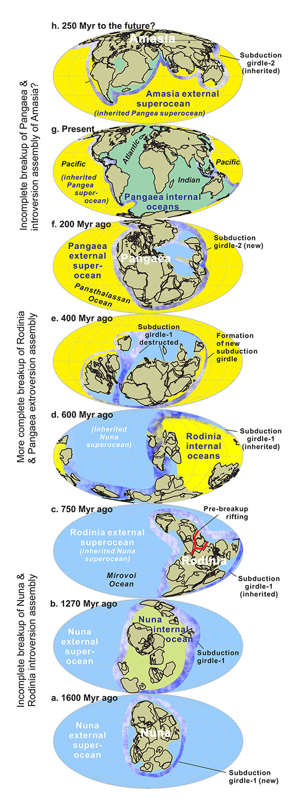
Figure 1. Survival of an external superocean over two supercontinent cycles as evidenced by global palaeogeography over the past 2000 Myr (a-h), and speculated corresponding mantle structures. Each major internal or external ocean system is colour-coded throughout the series of reconstructions. The assembly of Rodinia at 900 Ma (also future Amasia) is shown to be predominantly achieved through the closure of the internal ocean system formed as Nuna at 1400 Ma (or Pangaea at 170 Ma) fragmented (i.e. introversion), whereas the assembly of Pangaea was predominantly accomplished through the closure of the external ocean that surrounded Rodinia (i.e. extroversion).
Repeated, and possibly cyclic, events of supercontinent assembly and breakup have been increasingly recognised over the past two decades. The latest of such events was the supercontinent Pangaea (ca 320-170 Ma), preceded by Rodinia (ca 900-700 Ma), and by Nuna (ca 1600-1400 Ma), implying a cyclicity of ~600 ± 100 Myr. A similar cyclicity, with a 50-100 Myr time lag, is found in global mantle plume intensity, leading to a geodynamic model of a coupled supercontinent-superplume cycle in Earth history. However, variations in global zircon Hf isotopic signatures and seawater Sr isotope ratios are both characterised by a longer-term variation trend with ca twice the wavelength of a typical supercontinent cycle. This billion-year variation trend (or supercycle) is also exhibited in global juvenile crust generation, and by the distribution of ages of certain global-scale mineral deposits (such as lead and zinc deposits and orogenic gold deposits), but why?
Li et al. (CCFS publication #242) suggested that the answer lies in the evolution of Earth’s ocean basins. According to the model, supercontinents appear to assemble through two alternating pathways. One is extroversion (e.g. the assembly of Pangaea) where the previous supercontinent (Rodinia) was turned inside-out to form the new supercontinent, and in the process the superocean surrounding Rodinia was consumed (see Figures 1c to 1f). The other is introversion (e.g. the assembly of Rodinia), where the previous superocean surrounding Nuna survived the supercontinent cycle. In the latter case, the assembly of the new supercontinent occurred through the collapse of the internal oceans formed during the break-up of the previous supercontinent Nuna (Figures 1a to 1c).
More intriguingly, these two alternating methods of supercontinent assembly determine not only whether the superocean survives, but also whether the circum-superocean magmatism (e.g. the present-day Pacific Ring of Fire, which is scientifically referred to as the subduction girdle) survives. If this ring of fire survives along with the superocean, then the mantle structure maintains its pattern from the previous supercontinent cycle (the so-called degree-2 mantle structure; Fig. 2a). If not (in the case of extroversion supercontinent assembly), then the Earth’s mantle structure is completely reorganised from a degree-2 pattern into a so-called degree-1 pattern (Fig. 2b), with the new supercontinent formed over a giant mantle downwelling (shown in blue). We speculate that such alternating pathways of supercontinent assembly (along with the survival or regeneration of the superocean and ring of fire) have produced an Earth cycle which is twice as long as the ca 600 Myr supercontinent cycle, influencing the formation of some of Earth’s resources.
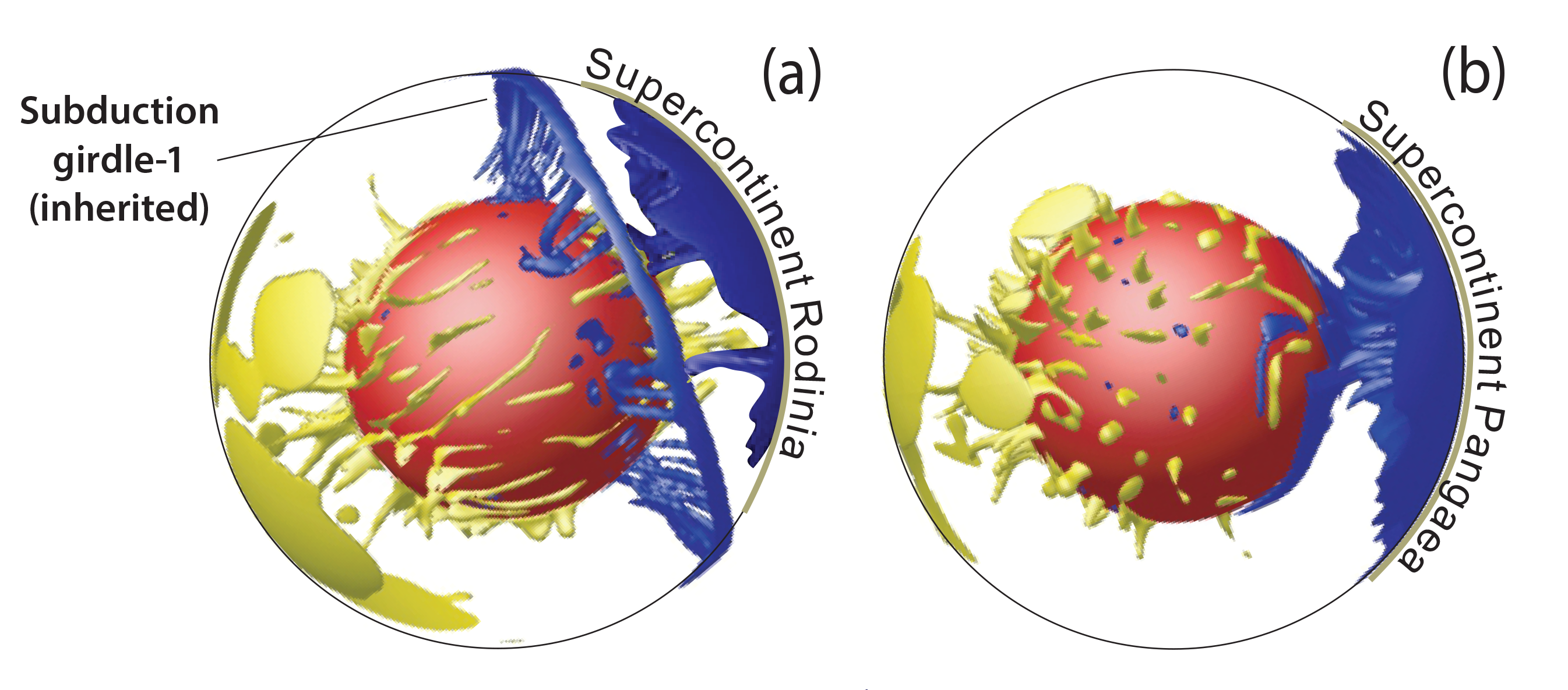
Figure 2. Different mantle structures related to the two different ways of supercontinent assembly. (a) A dominantly introverted supercontinent assembly inherits the pre-existing subduction girdle and degree-two mantle structure, along with the external superocean outside the subduction girdle. (b) A dominantly extroverted supercontinent assembly is accompanied by the destruction of the subduction girdle and the previous external superocean, where the new supercontinent forms above.
This project is part of CCFS theme 2, Earth’s Evolution, and contributes to understanding Earth’s Architecture and Fluid Fluxes.
Contact: Zheng-Xiang Li
Funded by: ARC Laureate Fellowship (ZX Li)
Volatile elements and metasomatism: how to move things around in the lithosphere
Volatile elements (C-H-N-S) are the chemical backbone for all essential organic molecules. They are also key to the planet’s habitability and its geodynamic activity, including ore forming processes. Exchanges between Earth’s interior and its exospheres (crust, hydrosphere, atmosphere) and biosphere occur during subduction and volcanism, but to what extent? What are the mechanisms and rates by which volatiles moves between deep and shallow reservoirs? What is the impact of mantle degassing on the secular evolution of the mantle and on the exospheres? As noted by the Deep Carbon Observatory (https://deepcarbon.net/) the inventory, cycles and behaviour of these key elements in the deep Earth are far from being constrained.
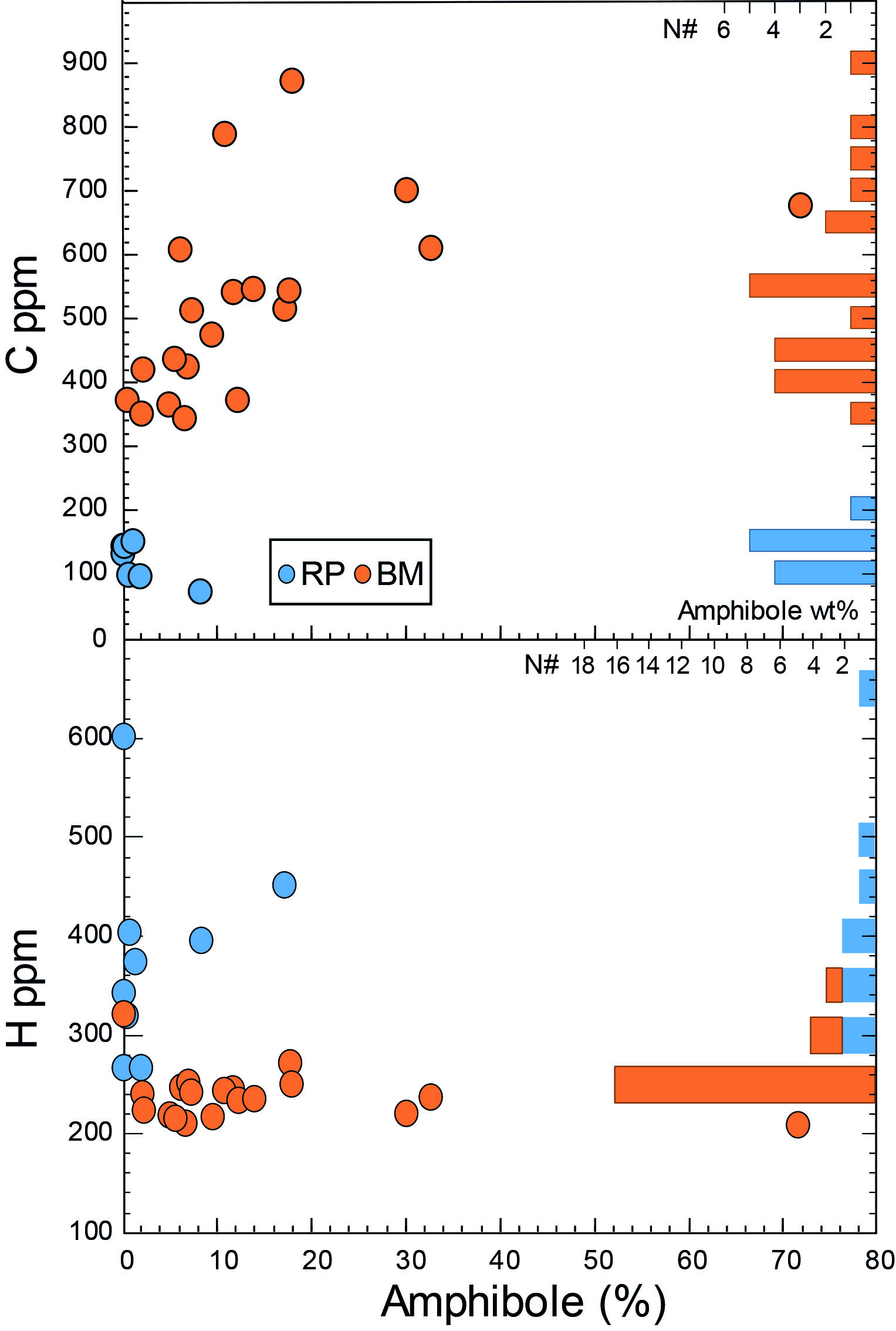
Figure 1. whole Rock C and H concentration (ppm) in amphibole bearing peridotite xenoliths from Ray-Pic (RP, Massif Central, France) and Bullenmerri (BM, Newer Volcanic Province, Au).
Because volatile elements have variable speciation they can be stored in the mantle in various ways: (i) as dissolved trace elements in the main silicate minerals (such as H in nominally anhydrous minerals: ol, opx, cpx); (ii) being a major element of specific/metasomatic phases, such as H in amphibole or C in carbonate, graphite and diamond; (iii) stored in melt/fluid inclusions; (iv) entering grain-boundary components. Therefore, their study requires a new approach integrating geochemical and mineralogical investigations at both whole-rock and mineral scales.
As a first step toward this aim, we have used an elemental analyser to determine whole-rock C, H, N and S contents in a series of alkali basalt-hosted peridotite xenoliths. Volatile contents vary widely (70-8000 ppm C; 50-485 ppm N, 90-1200 ppm H, 10-1500 ppm S). Eight well-characterised peridotite xenolith suites from alkali basalts were investigated, representing various degrees of melting and metasomatism. Correlations between C,H,N,S and melt-depletion criteria (e.g. Fo%, Al2O3WR) or metasomatic indicators (La/Sm) suggest that the variability in CHNS is not related to weathering or alteration but was mostly established during mantle processes. However, these relationships vary between suites. For example, the Ray Pic (RP) and Bullenmerri (BM) peridotites both contain amphibole. However RP xenoliths show H enrichment (up to ≈600 ppm), but low C contents (≈120±30 ppm) consistent with H2O contents of ca 1.4 wt% in the RP amphibole. BM xenoliths have in contrast low H contents (≈ 220 ppm) but clear enrichment in C (up to ≈700 ppm), well correlated with modal amphibole abundances (Figure 1). This difference in C and H behaviour is related to the distinctive trace-element patterns and amphibole compositions in each suite. In contrast, Borée peridotites, which contain no metasomatic amphibole, show high C and H contents (up to 1200 and 8000 ppm, respectively). Low H2O contents in ol, opx and cpx obtained by FTIR (in collaboration with S. Demouchy, Géoscience Montellier, Fr) indicate that C and H enrichments in BO xenoliths are not related to the main silicate minerals. Spitsbergen xenoliths show both high C and S contents in agreement with their well-documented occurrence of sulfide and carbonate-bearing metasomatic-pockets.
Volatile elements have always been considered to be a key component of most metasomatic melts/fluids invoked for modal, cryptic and stealth metasomatism. While mantle petrologists and geochemists have defined various metasomatic agents (including carbonatitic, carbonated, hydrous) with specific geochemical fingerprints, the nature of, and ratios between, the various volatile elements in these melts/fluids are still highly debated. Our preliminary results suggest that it may be possible to more closely constrain the relative abundance and behaviour of volatiles during these metasomatic processes and investigate their effects on the transport and fractionations of trace elements including chalcophile elements.
This project is part of CCFS theme 2, Earth’s Evolution, and contributes to understanding Earth’s Architecture and Fluid Fluxes.
Contacts: Ananuer Halimulati, Olivier Alard, Sue O’Reilly
Funded by: Olivier Alard ARC Future Fellowship, CCFS
The power of a systems approach to mineral and petroleum exploration in sedimentary basins
Petroleum systems and hydrothermal sedimentary rock-hosted copper, lead-zinc (clastic-dominated and Mississippi Valley-type), and uranium systems can be described in a common system framework comprising the critical processes of:
(1) establishing the fertility of source(s) of the commodity of interest and the transporting fluid,
(2) geodynamic triggers for commodity movement and accumulation,
(3) establishing an architecture for fluid movement,
(4) accumulation by deposition of the commodity, and
(5) preservation.
Consideration of these commodity systems in the context of the Earth’s evolving atmosphere-hydrosphere-biosphere-lithosphere highlights the power of paleotectonic, paleogeographic, and paleoenvironmental reconstructions in the critical step of basin selection. Such consideration also highlights common gaps in understanding the commodity systems. These knowledge gaps constitute high-value research paths that would provide greatest leverage in area selection at the basin and play scales. These include improved knowledge of paleogeographic and paleoenvironmental reconstructions, basin hydrodynamics, and timelines of mass and energy flow through basins. For metal systems, better understanding is required of how metal extraction efficiency, solubility, mineral precipitation, permeability, and pressure and temperature gradients dynamically interact along flow paths during the evolution of basins. See CCFS publication #1186.
Figure 1. Getech (unpub. commercial software, 2015) paleogeographic reconstruction at 257 Ma. The figure illustrates how paleogeographic and paleotectonic reconstruction has the power to screen basins for fertility. The Late Permian, one of the world’s great periods of deposition for petroleum source rocks, was also the time when the fertility for sedimentary rock-hosted copper and lead-zinc was established.
This project is part of CCFS themes 2 and 3, Earth’s Evolution and Earth Today, and contributes to understanding Earth’s Architecture and Fluid Fluxes.
Contact: Cam McCuaig
Funded by: BHP
Can olivine’s temperature diagnose the diamond potential of a kimberlite?
Kimberlite is the main volcanic host for transporting diamonds to the Earth’s surface. Kimberlites also entrain fragments of rock (xenoliths) and disaggregated single grains from the lithospheric mantle (xenocrysts) which can provide valuable windows into the region from about 40 to 250 km beneath the surface.
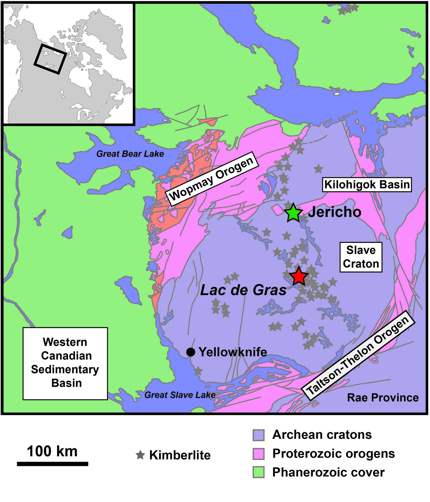
Figure 1. Map of the Slave Craton in northern Canada.
This study uses such xenoliths and xenocrysts from several kimberlite occurrences in the Cenozoic Lac de Gras kimberlite field in the Slave Craton, and the Jurassic (173 million years old) from northern Canada (Fig. 1). Geochemical data for abundant olivine xenocrysts in these two kimberlites are integrated to constrain their source depths. Olivine xenocrysts constitute about half the volume of these host rocks, and therefore their temperature profile may assist the identification of potential diamond occurrence, as diamond stability is limited to depths greater than ~140 km, equivalent to a temperature of 1000 °C. If the temperature of equilibration of at least some olivine xenocrysts indicate derivation from more than 140 km, diamond would be stable, and would have formed if there was sufficient carbon available.
Approximately 85% of the olivine xenocrysts studied here have compositions consistent with their derivation from mantle peridotites and pyroxenites. A new approach to single-grain olivine thermobarometry is being explored, based on the correlation between equilibration temperature, pressure and composition of olivine composition for the xenoliths from these localities.
A correlation between xenolithic olivine Mg# and pressure for most of these peridotitic and pyroxenitic bodies in the Jericho and Lac de Gras xenolith suites was observed. The relationship between xenolithic olivine Mg# and pressure thus may allow inferred estimates of the pressure (and by reference to the ambient geotherm, to the temperature) of xenocrysts assuming they derived from disaggregation of these source xenoliths.
Preliminary results suggest good agreement of the relative abundance of xenoliths and xenocrysts in the Lac de Gras pipes: both appear to be sourced predominantly from the deep lithospheric mantle (140-220 km; Fig. 2). At Jericho, xenoliths are sourced from as deep as 165 km, but xenocrysts appear to be exclusively above 140 km (Fig. 2).
The dominance of shallow material in the Jericho kimberlite may explain why the Jericho pipe has a lower concentration of diamonds than do the Lac de Gras mines
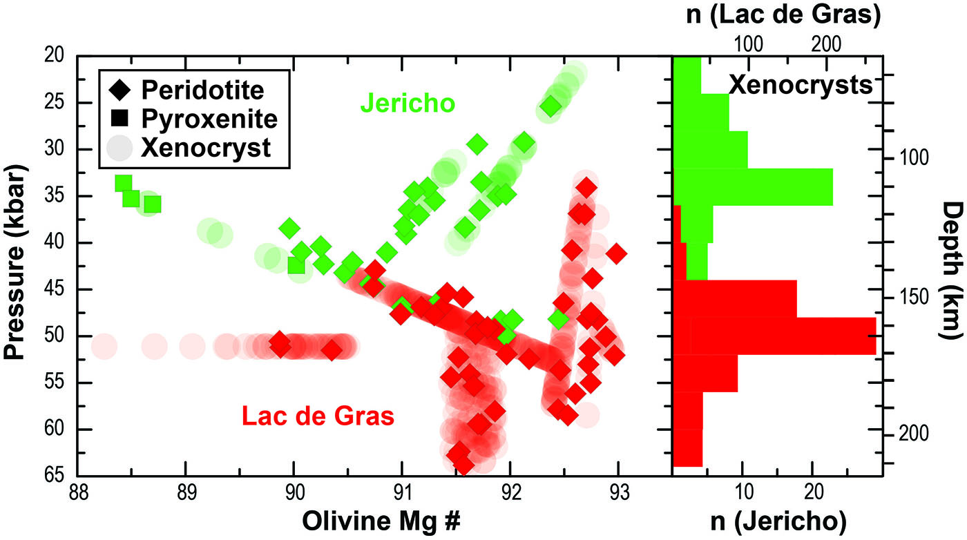
Figure 2. Pressure results for Jericho and Lac de Gras xenoliths compared to Mg# of olivine from xenoliths. Xenocrysts are projected onto the xenolith arrays and the depth profiles are expressed as a histogram.
This project is part of CCFS theme 2, Earth’s Evolution, and contributes to understanding Earth’s Architecture and Fluid Fluxes.
Contacts: Stephanie Greene, Dorrit Jacob, Zsanett Pintér, Sue O’Reilly, Larry Heaman (University of Alberta, Canada)
Funded by: CCFS
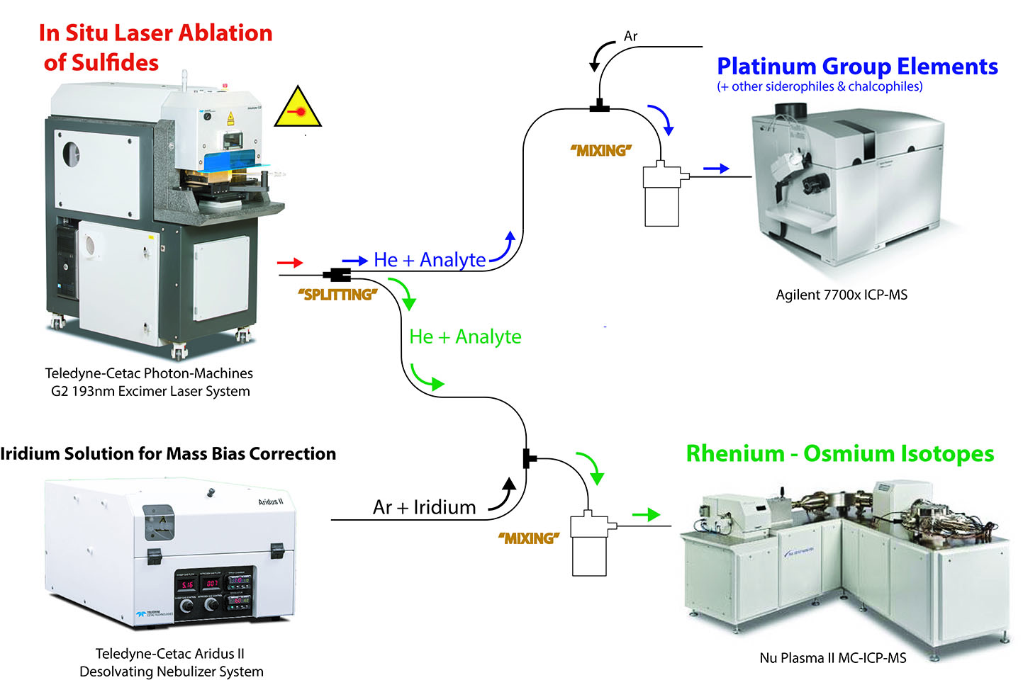
In situ laser ablation split-stream (LASS-) MC-ICP-MS for simultaneous determination of Re-Os isotopes and siderophile-chalcophile elements in sulfides: Ablating away a Cornelian dilemma
In 1999, in an important World’s first, GEMOC/GAU developed the techniques for in situ measurement of Re-Os isotopes in sulfides by LA-MC-ICPMS. It was then possible to date single in situ sulfide grains to infer the timing of melt-extraction events in the upper mantle. Since then the pioneering work of GEMOC/GAU demonstrated that elemental (e.g. PGEs) and isotopic in situ characterisations of (mantle) sulfides are powerful tools to unveil and date magmatic processes. Unfortunately, due to analytical and sample limitations (mantle sulfides Ø<100µm), investigators were left with the dilemma of choosing between trace elements or Re-Os isotopes.
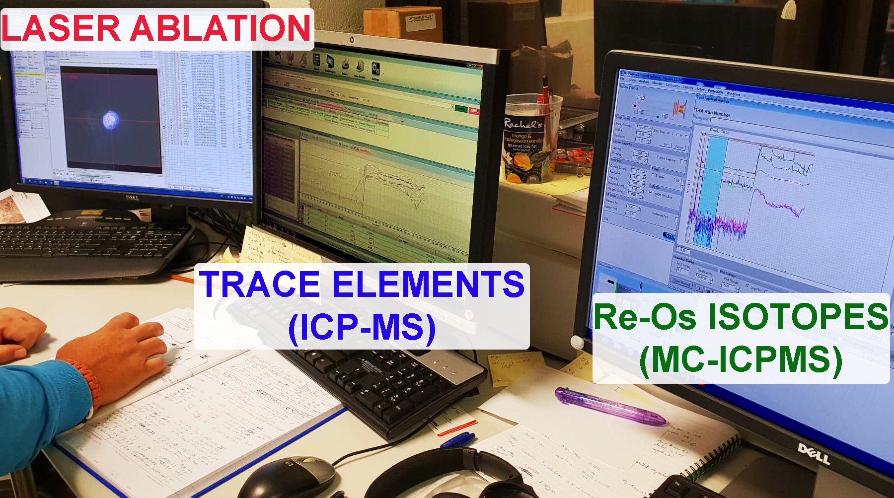
20 years later, we report a 2nd World’s first: we have now developed the capability to simultaneously measure in situ Re-Os isotopes and the concentrations of Platinum Group Elements (PGEs) in sulfides using laser ablation split stream (LASS) between a Nu Plasma II MC-ICPMS (Re-Os) and an Agilent 7700x Q-ICPMS (PGEs).
Owing to the considerable increase in sensitivity of the newer generations of Nu Instruments, and due to the ion counter inherent limitation, the amount of analyte sent to the Nu Plasma could be restricted, thus allowing us to divert the excess towards the ICP-MS for analysis of PGE and chalcophile trace element abundances. While the trace-element signal has been lowered by ≈50%, in contrast the implementation of the LASS was done without any loss of sensitivity (and thus precision) for the MC-ICP-MS. Although counting statistics are significantly lower (≈50%) for the ICP-MS, the accuracy and reproducibility for trace elements in reference materials (e.g. Po62, Ai3-W, FeS1) are satisfactory. For instance, Os content in Po62 is ca 1.67±0.06 ppm, while the Se content of AI3-W was found to be 168±1 ppm.
This technological breakthrough provides a significant increase in time efficiency as both measurements are now acquired in a single session. However the real advance resides in the ability to not have to choose between one or the other type of measurement. Therefore, this new methodology will enable us to build more comprehensive datasets offering better constraints on the systematics between the isotopic signatures and the trace-elements patterns of the sulfides, which will allow more accurate petro-geochemical understanding of the nature and timing of the processes occurring in the upper mantle.
Contacts: Olivier Alard, Yoann Gréau
Funded by: CCFS
Holy hibonite! - ‘meteoritic’ mineral assemblages in volcanic rocks
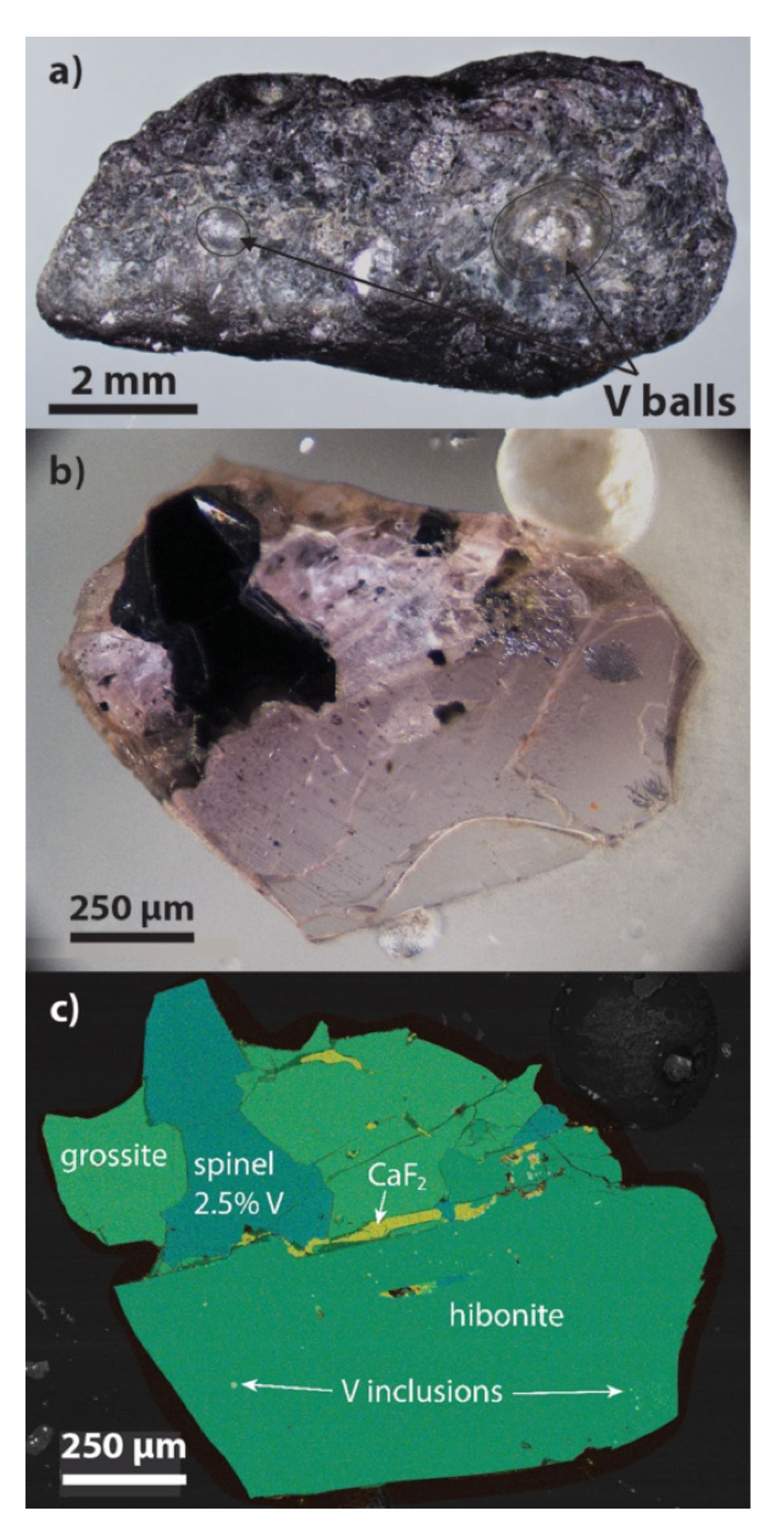
Figure 1. Hibonite-grossite aggregates. (a) large grain of hibonite-grossite aggregate with mm-size spheres of native V (V0); (b) transmitted-light photo of transparent specimen, enclosing black spinel grain and rods of V0; (c) phase map of (b) showing paragenesis of aggregates. Comparison of (b) and (c) shows that each tiny V0 inclusion represents the end of a long rod or dendrite branch.
Hibonite (CaAl12O19) is a constituent of some refractory Calcium-Aluminium Inclusions (CAIs) in carbonaceous meteorites, commonly accompanied by grossite (CaAl4O7) and spinel. These phases are usually interpreted as having condensed, or crystallised from silicate melts, early in the evolution of the solar nebula. Both Ca-Al oxides are commonly found on Earth, but as products of high-temperature metamorphism of pelitic carbonate rocks. However, our ongoing studies of the ultra-reduced mineral assemblages in the ejecta from Cretaceous pyroclastic deposits on Mt Carmel, N. Israel have identified unique magmatic hibonite-grossite-spinel assemblages, crystallised from Ca-Al-rich silicate melts under conditions (high temperature, very low oxygen fugacity (fO2)) comparable to those of their meteoritic counterparts.
The Mt Carmel material includes aggregates of hopper/skeletal Ti-rich corundum, which have trapped melts that crystallised at fO2 extending from 7 log units below the Iron-Wustite buffer (ΔIW= -7; SiC, Ti2O3, Fe-Ti silicide melts) to ΔIW ≤ -9 (native V, TiC, TiN). The assemblage hibonite + grossite + spinel + TiN first crystallised late in the evolution of the melt pockets; this hibonite contains % levels of Zr, Ti and REE, reflecting the concentration of incompatible elements in the residual melts as corundum continued to crystallise.
A still later stage appears to be represented by coarse-grained (cm-size crystals) ejecta that show the crystallisation sequence: corundum + Liq → (low-REE) hibonite → grossite + spinel ± krotite (CaAlO4) → Ca4Al6F2O12 + fluorite ± perovskite (CaTiO3). This is the first reported terrestrial occurrence of krotite, which is otherwise found in CAIs. Ca4Al6F2O12 has been produced synthetically, but not previously found in nature; it is important because it is unstable below 1150 °C and constrains the temperature range of the assemblages. V0 appears as spheroidal droplets, balls up to mm size, and spectacular dendritic growths, included in hibonite, grossite and spinel (see Research highlight Vanadium melts reflect Earth’s most reducing conditions). Spinels contain 10-16 wt% V in V0-free samples, and <0.5 wt% V in samples with abundant V0.
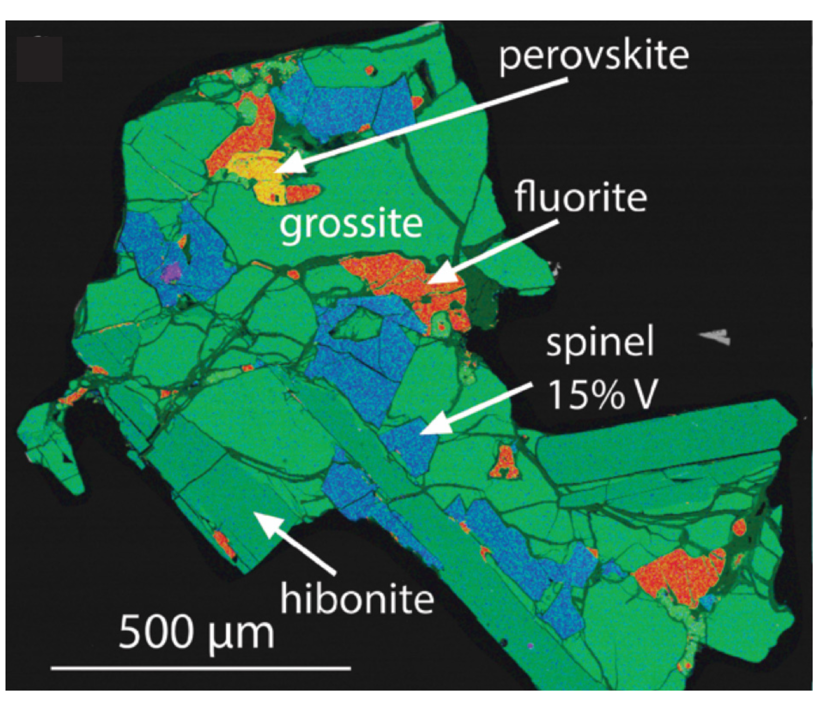
Figure 2. Hibonite-grossite aggregate illustrating crystallisation sequence. Resorbed corundum in hibonite reflects peritectic reaction L + Cor → Hib, followed by grossite + spinel ± krotite; fluorite and Ca4Al6F2O12 crystallise last.
Ongoing paragenetic studies (see CCFS Annual Report 2017) suggest that the fO2 evolution of the Mt Carmel magmatic system reflects interaction between OIB-type mafic magmas and mantle-derived CH4 + H2 fluids near the crust-mantle boundary. Temperatures estimated by comparison with 1-atm. phase-equilibrium studies range from ca 1500 °C down to 1200-1150 °C.
When fO2 reached ca ΔIW = -7, the immiscible segregation of Fe,Ti-silicide melts and the crystallisation of SiC and TiC effectively desilicated the magma, leading to supersaturation in Al2O3 and the rapid crystallisation of corundum, leading finally to the development of the hibonite-bearing assemblages.
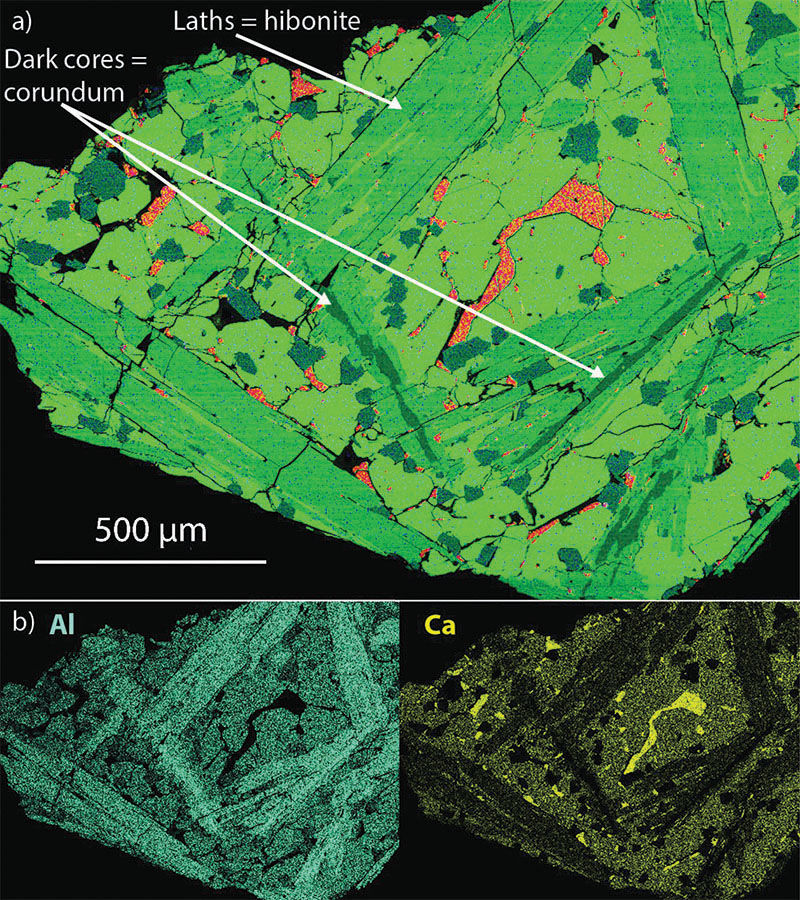
Figure 3. (a) Phase map of aggregate showing randomly-oriented hibonite plates, with narrow resorbed corundum cores, and hibonite + grossite intergrowths at edges of plates. Grossite (light green) is euhedral against CaF2 (orange), the last phase to crystallise. Spinels (blue-green) are euhedral.
The analogies to the mineralogy of CAIs suggest that this work is also relevant to studies of processes in the early Solar system. See CCFS publication #1209.
This project is part of CCFS theme 2, Earth’s Evolution, and contributes to understanding Earth’s Fluid Fluxes.
Contact: Bill Griffin
Funded by: CCFS Flagship program 1
Early cratonisation of the Yangtze Craton
The Earth is unique among terrestrial planets for its extensive regions of felsic crust, making up the continents. The felsic continental crust was largely generated during Archean time (>2.5 billion years ago), through tonalite-trondhjemite-granodiorite (TTG) magmatism, but exactly when and how such TTG-dominated crust formed and evolved into mature granitic compositions similar to modern upper crust is contentious.
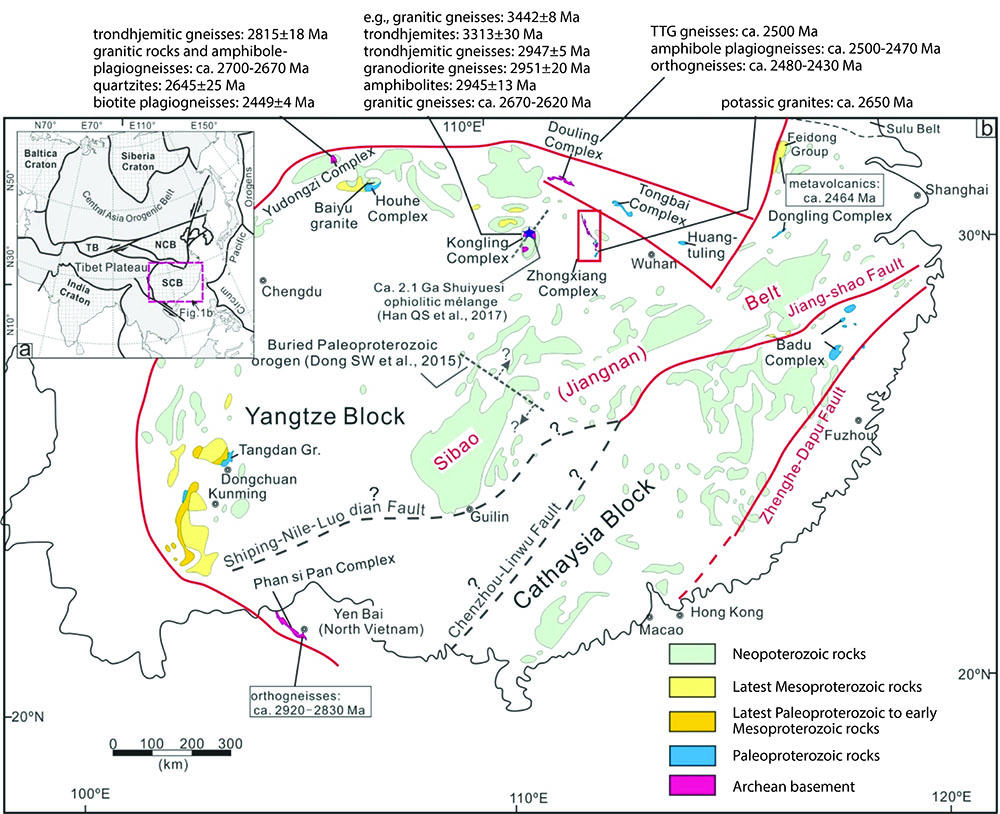
Figure 1. (a) Simplified tectonic map of Eurasia showing the major tectonic units and the location of SCB - South China Block, TB - Tarim Block, and NCB - North China Block. (b) A simplified geological map highlighting the Precambrian geological units of south China. Note the distribution of the Archean magmatic rocks along the northern and southern Yangtze margins.
The Yangtze Craton, southern China (Fig. 1) is one of the oldest blocks of continental East Asia, although the exact timing and evolution of, and the spatiotemporal relationships between these crustal provinces are not well understood.
Recent work has contributed to the recognition of several Archean crustal provinces (i.e. the Kongling Complex, the Yudongzi Complex, the Douling Complex, and the Zhongxiang Complex) in this Craton. The newly discovered Zhongxiang Complex in the northern Yangtze Craton (Fig. 1b) is among the known Archean crustal provinces and documents both sodic TTG and potassic granitic magmatism, providing a critical record of the evolving continental crust. An integrated study of petrology, zircon U-Pb geochronology and Hf-isotopes, and whole-rock geochemistry was conducted on the Zhongxiang Complex to better understand the crustal history. Our results revealed three major periods of Archean felsic magmatism in the Zhongxiang Complex: late Mesoarchean (2.90-2.87 Ga), early Neoarchean (2.77 Ga), and late Neoarchean (2.70-2.62 Ga). The 2.90-2.87 Ga magmatism is represented by monzogranites from the southern Zhongxiang Complex, which were derived from mixing of ancient and juvenile crustal components at relatively shallow crustal depths. This was followed by the emplacement of 2.77 Ga trondhjemitic gneisses in nearby regions of the southern Zhongxiang Complex, which represent the only potential TTG with ages of 2.80-2.70 Ga in the Yangtze Craton. The trondhjemitic gneisses are typical of a medium-pressure TTG component and are interpreted as the products of partial melting of a basaltic source with appreciable involvement of pre-existing crustal components (i.e. tonalites). In contrast, the 2.67-2.62 Ga magmatism, represented by potassic granites from the northern Zhongxiang Complex, corresponds to high-temperature melting of meta-sedimentary source rocks in a within-plate extensional setting.
The transition of the felsic magma from Na-rich (2.77 Ga) toward K-rich (2.67-2.62 Ga) in the Zhongxiang Complex would have led to extensive removal of heat-producing elements from the lower crust, enabling the thermal stabilisation of the continental crust. This transition is broadly coeval with global TTG-granite and tectonic transitions related to thermo-mechanical and geodynamic changes of the continental crust at the end of the Archean, but appears to slightly postdate the TTG-granite transition in the nearby Kongling Complex (2.90-2.80 Ga) and to predate those in the Yudongzi Complex (2.70 Ga) and the Douling Complex (2.50 Ga), all of which are documented from the Yangtze Craton. Age and isotopic comparisons among the known Archean provinces further indicate a compositionally heterogeneous Archean Yangtze Craton, which likely comprises several Archean terranes that accreted to form the craton during the late Archean or even early Paleoproterozoic (Fig. 2).
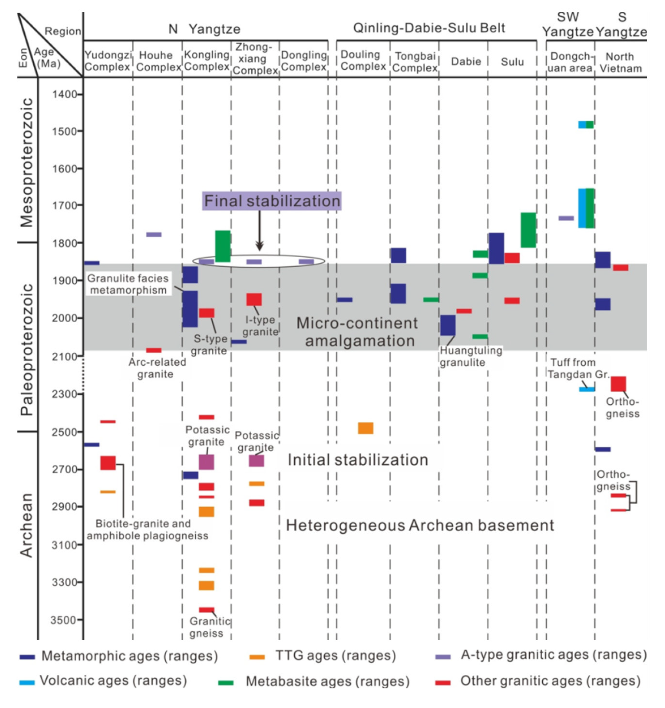
Figure 2. Time-space correlation chart of the Yangtze Craton illustrating the age ranges of principal Archean to early Proterozoic (>1.4 Ga) tectono-thermal events recorded in different parts of the Yangtze Craton. The compositionally variable Archean continental crust among different crustal domains of the Yangtze Craton, and their similar orogenic-related magmatic and metamorphic overprint during the late Paleoproterozoic point to the formation of a uniform Yangtze Craton by accretion of several crustal domains or terranes during the late Archean to Paleoproterozoic time. The concurrent emplacement of ca. 1.85 Ga A-type granites at different localities likely marked the final stabilisation of a coherent Yangtze Craton.
This project is part of CCFS themes 1 and 2, Early Earth and Earth’s Evolution, and contributes to understanding Earth’s Architecture.
Contacts: Kai Wang, Zheng-Xiang Li, Earth Dynamic Research Group, Curtin University
Funded by: ARC Laureate Fellowship (ZX Li)
Sulfide aggregation in ophiolitic dunite channels amplifies Os-isotope mismatch between oceanic crust and mantle
Re-Os isotopic compositions of oceanic crust represented by fresh basaltic glasses from the mid-ocean ridges and primitive gabbroic cumulates in the ridge system are systematically more radiogenic than the normal values for Os isotopes [quartiles of γOs(t) with Q1= -4.1 and Q3= -0.6] of oceanic mantle, represented by abyssal peridotites and Os-Ir alloys from global ophiolites which are below the values for chondrites - i.e. ‘sub-chondritic’. Os isotopic decoupling between oceanic crust and mantle has been explained by radiogenic Os contributions from metasomatic sulfides and/or recycled pyroxenites in the convective mantle. However, the possible role of melt channels that regulate the flow of magmas feeding the oceanic crust at the crust-mantle boundary, have so far not been considered.
in situ Re-Os isotopic compositions of nearly 200 base-metal sulfide grains have been analysed from the ophiolitic low-Cr# chromitites from Zedang (South Tibet) (CCFS Publication #965). These chromitites occur within dunite lenses, interpreted as interaction products between MORB-like melts and harzburgites. Thirty-eight analyses (mainly sulfide inclusions in chromite) show a wide range of (187Os/188Os (calculated at 130 Ma) from 0.1191 to 0.1702 with γOs(t) from -6.4 to +33.8. These values are similar to those of the oceanic crust and the Os-rich sulfides from the Oman low-Cr# chromitites. The initial 187Os/188Os ratios (0.1281-0.1296) of chromites from the Zedang chromitites are close to those for the Primitive Upper Mantle, but higher than those of the Zedang and other ophiolitic peridotites along the Yarlung Zangbo suture (South Tibet). This suggests that radiogenic Os components from asthenospheric or lithospheric mantle have been added to the dunite melt channels. The significant Os isotopic heterogeneity observed in the Zedang and Oman chromitites indicates that the Os-bearing phases were not well mixed, but aggregated together during the precipitation of chromite and monosulfide solid solution grains, when the dunite melt channels were produced in the oceanic crust-mantle transition zone. Such melt channels will affect the Os isotopic compositions of the migrating melts that ultimately generate the oceanic crust: and this process can explain the Os isotopic mismatch between oceanic crust and mantle (Fig. 1).
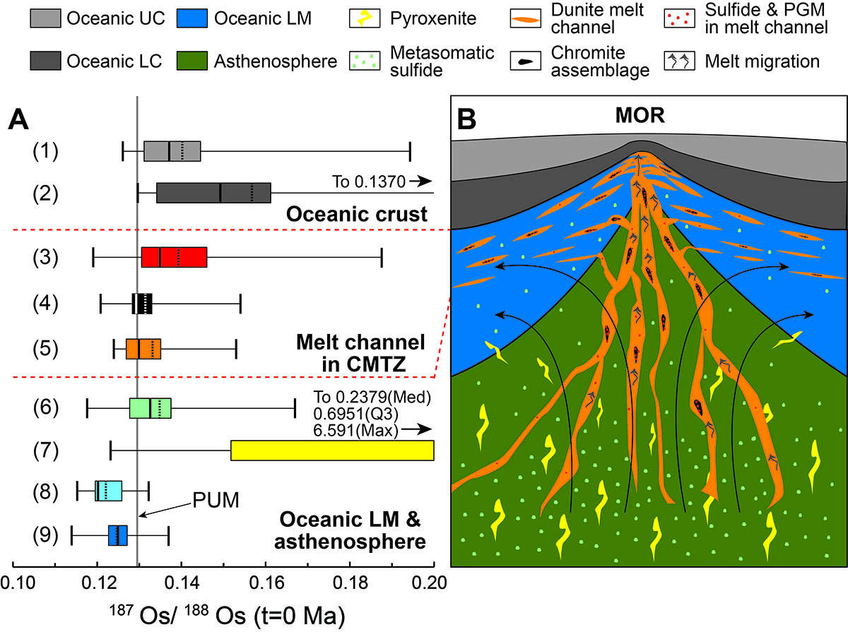
Figure 1. Comparison of box-whisker plots (A) for 187Os/188Os (t=0 Ma) ratios of oceanic crust, dunite melt channels and mantle. A schematic cartoon (B) shows the formation and distribution of dunite melt channels and relevant chromite assemblages beneath a mid-ocean ridge (MOR). Discrete Os components with heterogeneous Os isotopic compositions from the asthenosphere or lithospheric mantle were aggregated in the dunite melt channels, which regulate and contribute the Os isotopes of oceanic crust. Abbreviations: UC, upper crust; LC, lower crust; CMTZ, crust-mantle transition zone; LM, lithospheric mantle.
This project is part of CCFS theme 2, Earth’s Evolution, and contributes to understanding Earth’s Architecture and Fluid Fluxes.
Contacts: Qing Xiong, José M. González-Jiménez, Jian-Ping Zheng, Bill Griffin, Sue O’Reilly
Funded by: NSFC (41520104003 and 41873032), CCFS Flagship Program 1
Pyroxenite microstructures help unlock deep Earth secrets
Seismic waves and their response to the mediums they travel through provide most of our knowledge of the structures and discontinuities of the deep Earth. Most minerals in Earth’s mantle have strongly directional elastic properties, and thus the seismic waves passing through them will be slightly accelerated or decelerated depending on the incidence direction. Therefore, to improve the characterisation of the architecture of Earth’s mantle, we need to be able to accurately interpret the geological significance of seismic dataset.
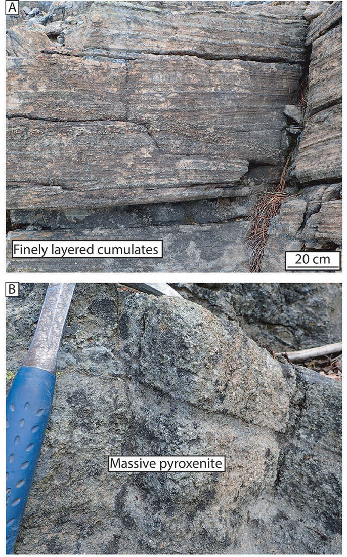
Figure 1. Field pictures of (A) the finely layered cumulates displaying the characteristic high-frequency layering and (B) Massive clinopyroxenites with significantly less olivine-rich layers.
Olivine is the dominant mineral in Earth’s upper mantle, but pyroxenes can be volumetrically dominant in specific geological contexts. A previous Research Highlight (CCFS 2016 Annual Report) and CCFS publication #969 examined the microstructure of deformed pyroxenites from the exhumed mantle terrane at Cabo Ortegal (Spain). In order to fully characterise the nature of deformation in pyroxenites, we also studied pyroxenites from the Trinity Ophiolite (USA), an undeformed analogue of the Cabo Ortegal pyroxenites.
Within the Trinity ophiolite, California, USA, the fossil magma chamber of Bear Creek contains abundant pyroxene-rich facies showing no evidence for plastic deformation. Down-section, the pyroxenite cumulates commonly alternate between olivine-rich and pyroxene-rich layers (Fig. 1B). Up-section, the frequency of olivine-rich layers decreases gradually until massive clinopyroxenites outcrop (Fig 1B).
Spatial orientations of the pyroxene and olivine grains in this cumulate suite were determined using the Electron Back-Scattered Diffraction (EBSD) technique. Our data demonstrate that magmatic processes in a magma chamber can cause strong preferred crystal orientation of the mineral grains. This preferred orientation is strongly planar, as observed in the field, but the grains have a cryptic preferred orientation within that plane (Fig. 2). We interpret this to be the result of the grains settling to the base of the magma chamber, oriented in a preferred crystallographic plane and/or as the result of compaction.
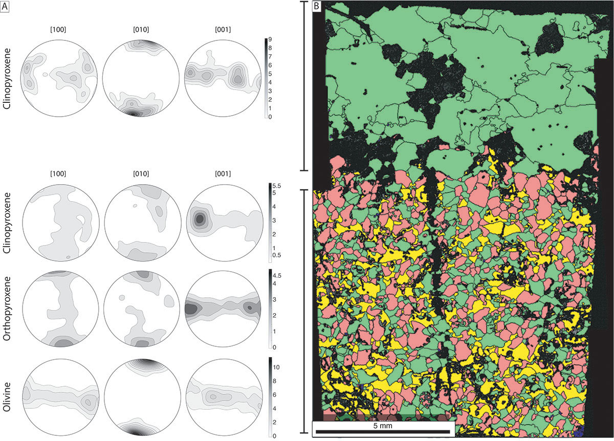
Figure 2. (A) Crystallographic preferred orientation of the rock-forming minerals along a sample where finely layered cumulates (bottom) and massive pyroxenites (top) are in contact. The strong planar feature is highlighted by the girdles formed by the [001] axis for all minerals. (B) Colour-coded map representing the distribution of the phases in the sample. Yellow codes for olivine, green for clinopyroxene and red for orthopyroxene. Black denotes non-indexed data.
From a seismic perspective, fabrics from the Bear Creek cumulates show a distinctive anisotropy unique to such pyroxenite fabrics, and thus making them potentially seismically distinguishable from ‘average’ lherzolitic upper mantle.
Our results further suggest that the pre-existing magmatic fabric could influence the behaviour of cumulate rocks during later deformation, because the pre-existing fabric will result in a favourably oriented set of slip systems that could be easily activated. This emphasises the caution required when interpreting deformation conditions based on slip system activation.
This project is part of CCFS themes 2 and 3, Earth’s Evolution and Earth Today, and contributes to understanding Earth’s Architecture and Fluid Fluxes.
Contact: Hadrien Henry
Funded by: CCFS, Centre National de la Recherche Scientifique (CNRS), France
Persistent ancient oceanic slab hovers in the upper mantle of western China?
Ancient oceanic slabs generally cannot be preserved in continental lithosphere for significant periods of time. Ancient subduction zones, which can provide important clues to the past tectonics, have rarely been imaged by geophysical techniques. However, the Junggar terrain (Fig. 1) appears to be an exception where a fossil oceanic slab has been well preserved since the late Paleozoic. The unique evolution history and the lack of subsequent thermal events in this region provide an undisturbed environment allowing the slab to remain until the present. Imaging the detailed geometry of the fossil subduction system in this region helps us to investigate the past tectonic process.
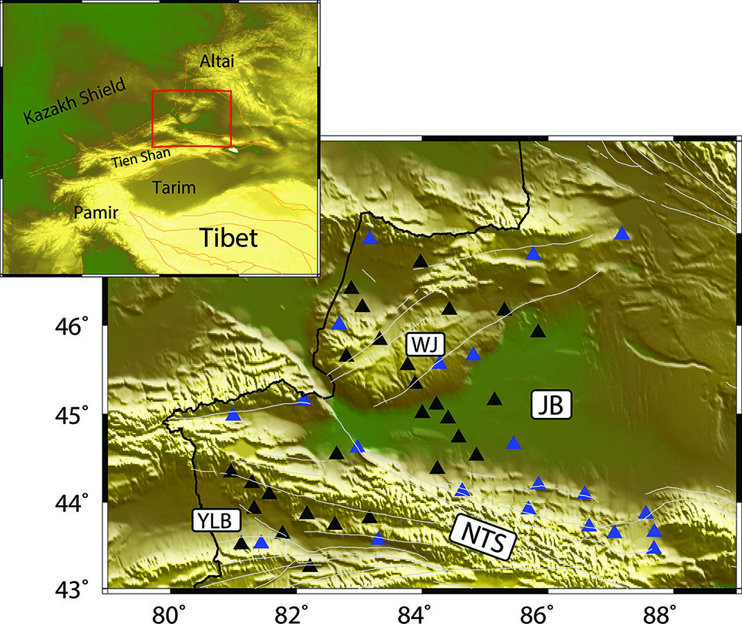
Figure 1. Location of the study region (red rectangle) and the broadband seismic stations. Blue triangles represent the 21 fixed stations from CEA and black triangles indicate the 28 deployed stations. Tectonic blocks around study region are outlined by orange lines, grey solid lines are the location of major faults, and the black solid line is the Chinese national border. WJ: West Junggar (or the Zaire mountains); YLB: Yili Block; JB: Junggar Basin or Dzungarian Basin; NTS: Chinese northern Tien Shan (or the Borohoro Mountains).
We deployed a seismic array occupying a larger spatial region across the Junggar Terrane (Fig. 1), in order to generate a high-resolution velocity model for the crust and upper mantle. This array consisted of 28 newly deployed broadband seismic stations from July 2016 to September 2017 along with 21 permanent stations from the China Earthquake Administration (CEA) Array. Based on data from this array, shear-wave velocity (Vs) models of the crust and upper mantle in the Junggar terrane are constructed using ambient noise and teleseismic surface-wave tomography techniques. According to our Vs model (Fig. 2), the patterns of velocity anomalies in the shallow crust agree well with the geological features in the surface. A large triangular-shaped low velocity zone dominates the entire Junggar Basin, corresponding to the thick sedimentary layer within the basin (~8-9 km in the north and over 10 km in the south). For the deeper structures, inverse velocity features compared to those observed for the shallow crust, characterise the study region with high velocities occupying the entire Junggar Basin.
One vertical profile (AA’) is plotted in Fig. 3 to illustrate the vertical variations of velocity structures. This profile starts at the northern foothill of Northern Tien Shan and runs northwestward through the entire Junggar Basin and to the West Junggar. This ~400 km cross-section shows several interesting features. In the upper crust, the Junggar Basin is imaged as a prominent low Vs zone, with shear velocities much lower than 3.0 km/s. The thickest part of this low velocity body occurs beneath the southern margin of the Junggar Basin. At the depths of middle to lower crust, the Vs beneath Junggar Basin increases significantly, reaching ~3.9 km/s to ~4.0 km/s in the lowermost crust. The mid/lower crust high velocities extend into the NTS in the south, and dip toward northwest with depth underneath the West Junggar. The uppermost mantle is dominated by a high velocity body beneath Junggar Basin and Northern Tien Shan. The thickness of this high velocity layer is ~60 km with Vs higher than 4.65 km/s. In the margin between Junggar Basin and West Junggar, this high velocity domain slightly dips northwest, reaching a depth around 150 km. High velocity domains are also observed to the west part of West Junggar with a thickness of only ~30 km, thinner than the high velocity layer beneath the WJ and Northern Tien Shan. The uppermost mantle of West Junggar is dominated by a relatively low velocity anomaly extending to a depth of ~240 km.
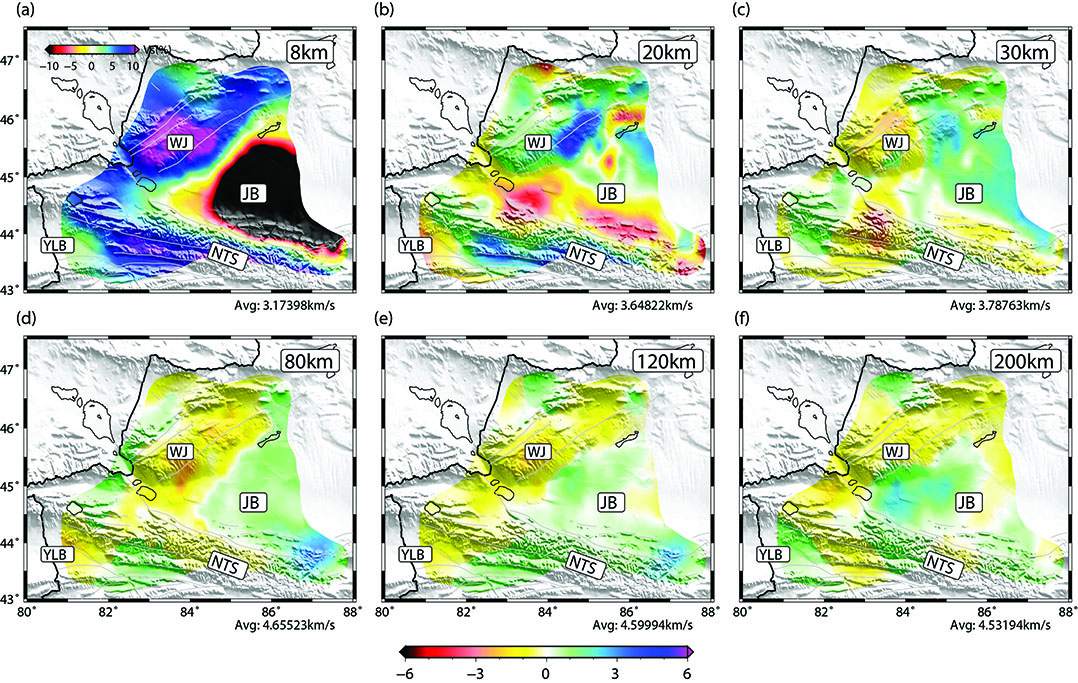
Figure 2. Vs perturbation maps at six different depths ranging from 8 km to 200 km. Colour pattern for the depth of 8 km is different from others and plotted in the top of (a). The average Vs is labelled at the bottom right of each subfigure.
Integration with previous magnetotelluric, geochemical, geochronological and geomagnetic studies in the Junggar Basin as the remnant of the ancient oceanic lithosphere beneath the ancient Junggar Ocean. In the AA’ profile beneath West Junggar, the upper mantle high velocity body slightly dips northwestward and then terminates at a depth of around 150 km. According to the geometry of the high velocity body, it is reasonable to deduce the polarity of the late Paleozoic subduction in the West Junggar is northwest. We then compare the current geothermal model in the Junggar region with the predicted oceanic slab half-space cooling model. The perfect match between them supports the hypothesis that the high velocity beneath the Junggar Basin at the lower crust and upper mantle depths, reflects the trapped Late Paleozoic oceanic slab. This finding is significant since very few ancient oceanic slabs can be preserved and imaged in continental collision zones worldwide. Also, the imaged, well-preserved subduction system in the Junggar terrane provides vital constraints for the past tectonics in this region.
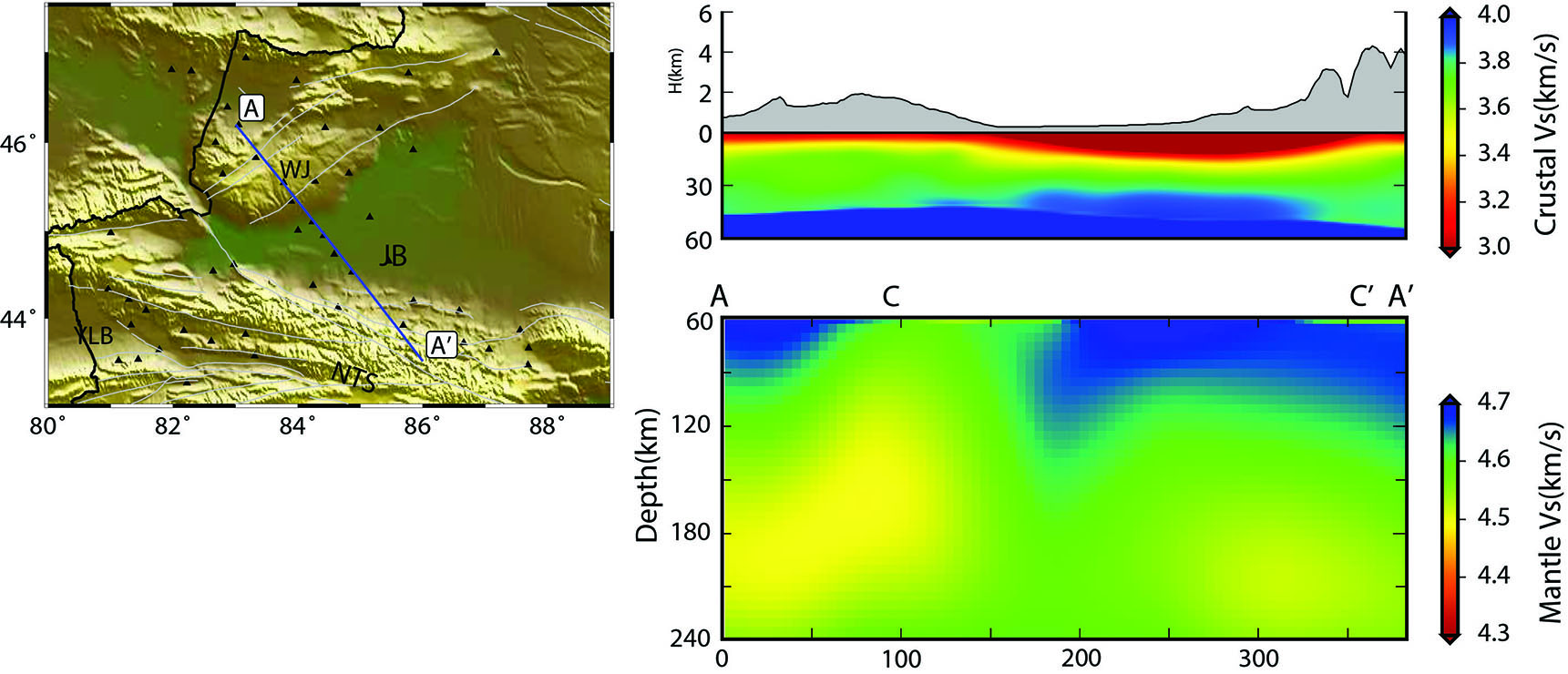
Figure 3. Vertical cross-section with the location marked in the topographic map. Note that two different colour patterns are used to plot the crustal and mantle structures.
This project is part of CCFS theme 3, Earth Today, and contributes to understanding Earth’s Architecture.
Contacts: Shucheng Wu, Yingjie Yang
Funded by: CCFS Flagship Program 3, NSFC 41530319, iMQRES 44659946
Vanadium melts reflect Earth’s most reducing conditions
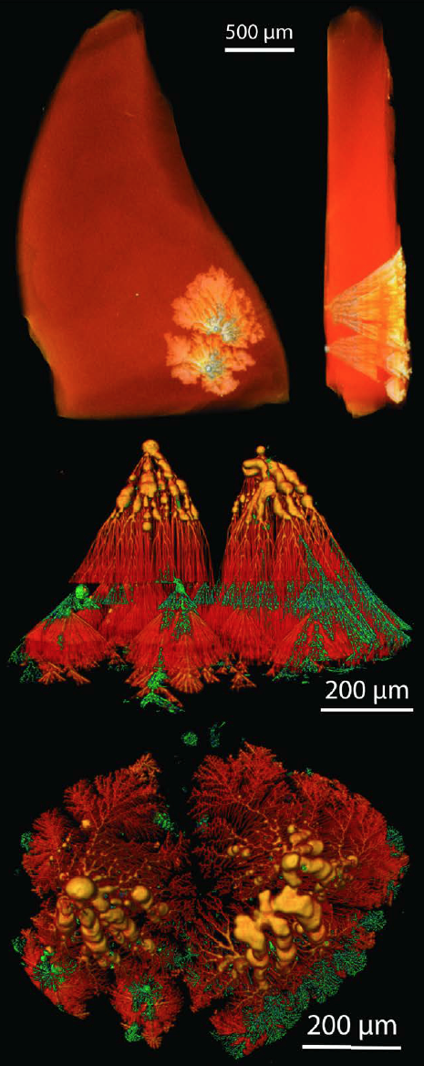
The pyroclastic ejecta of Cretaceous intraplate basaltic volcanoes exposed on Mt Carmel, in northern Israel, provide snapshots of unusual melt-fluid systems, sampled at different stages of their evolution. Now they have provided evidence of the most reducing conditions ever found on Earth, reflecting a hydrogen-dominated fluid phase.
Figure 1. 3D-µCT images of dendritic native V in hibonite. a) low-resolution image of two dendrite clusters in a hibonite grain. b) magnified view, looking parallel to (0001) face; red to orange, vanadium; green, open cavities; (c) view from starting point, toward crystal face along c axis. Tendrils radiate off irregular clumps of V0. Some consist of a series of joined balls that extend toward the crystal surface, then sprout into 3-D dendritic networks with clear breaks and restarts at intermediate crystal planes. The patterns suggest nucleation of V melts on the surface of growing crystals. Cover image.
View 3D images HERE.
Aggregates of skeletal corundum crystals found in the ejecta and secondary alluvial deposits contain melt pockets requiring high T (>1450-1200 °C), moderate P (ca 1 GPa) and extremely low oxygen fugacity (fO2). Paragenetic studies (Griffin et al., 2018, 2019a; Xiong et al., 2017) suggest that the crystallisation of skeletal corundum and low fO2 reflect the interaction of originally mafic magmas with CH4 + H2 at high fluid/melt ratios.
As the magmas were progressively reduced, the original silicate melts were depleted in Fe and Si by the exsolution of immiscible Fe-Ti-C-silicide melts that crystallised moissanite (SiC) and khamrabaevite (TiC). Still lower fO2 is witnessed by inclusions of Ti2+-bearing phases (TiB2, TiN, TiC, TiO). The silicide melts efficiently scavenged Fe and heavier transition elements; no Fe-Ni-Co-bearing oxides or silicates are found in the melt pockets. The assemblages described here thus formed from residual melts, enriched in Ca, Al and minor elements (REE, Zr, Ti, V, Mn, Sc).
Hibonite (CaAl12O19) first appears together with corundum, Mg-Al spinel, TiN, Fe-Ti silicides, TiC and glass (see Research highlight Holy hibonite! - ‘meteoritic’ mineral assemblages in volcanic rocks). Coarser-grained (to cm-sized crystals) intergrowths of hibonite, grossite and spinel also occur as grains up to 2.5 cm across in placers of the Kishon and Yoqneam Rivers that drain Mt Carmel. They suggest that hibonite-bearing melts like those trapped in the corundum aggregates evolved even further beneath some volcanic centres.
In these xenoliths, native vanadium (V0) and V-Al alloys occur mainly as spheroidal to amoeboid balls up to mm size in hibonite crystals. More commonly, V0 forms droplets on (0001) planes, or rods normal to (0001) that commonly are necked down to produce linear trains of droplets. The inclusions are zonally distributed in some crystals.
Rare V0 inclusions develop (Fig. 1) into ’dense branching structures’ (Goldenfeld, 1989). These grow roughly parallel with the c-axis of the host hibonite crystal, and each filament terminates in a single dendritic crystal. Clusters of fine branches terminate at planes parallel to (0001), suggesting a pause in the growth of the hibonite crystal. Some branches continued to grow when crystal growth resumed, but new droplets of V0 also nucleated on the new crystal plane and grew independently of the older branches. In the example shown in Figure 1, this stop-start process occurred at least four times. 3D-µCT images (scan QR code, inside cover) show that the outer parts of many filaments are 'empty’, even where they terminate well below the present crystal face.
The structures shown in Figures 1 and 2 are best explained by the nucleation of drops of molten vanadium on the faces of oxide crystals exposed to the silicate melt. These drops attracted more V0 as the crystal grew, producing larger and elongated (sometimes hollow) inclusions. The formation of dense branching structures reflects diffusion-controlled interface motion, such as the growth of a crystal into a fluid, under conditions of mild to strong supercooling.
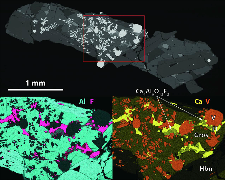
Figure 2. High-Al (mean 15 wt%) V balls in nest of grossulite between hibonite laths, with outlines suggesting they were fluid when trapped.
The melting point of vanadium is >1900 °C - so how could V0 melts be present in this relatively low-T system? The answer lies in the reducing conditions. The fO2 required for the presence of V0 (≤ΔIW -9) implies a hydrogen-dominated environment, equivalent to the early solar nebula (Grossman et al., 2008). Analyses of hibonite grains have revealed hydrogen concentrations up to 0.5 wt%, suggesting that the ‘voids’ are filled with H2, and grains of VH2 (the first natural metal hydride) occur among the V0 balls (Bindi et al., 2019). In a hydrogen atmosphere, the melting point of vanadium can be lowered by >1000°C as H2 dissolves in the melt, only to be expelled during solidification. We suggest that these hollow tubes and voids reflect the exsolution of H2 from the solidifying V0 melts in the inner parts of the structures, leading to the remelting and expulsion of V0 in the outer parts, before the next layer of hibonite nucleated, and perhaps to production of the observed VH2 phase.
The assemblages from Mt Carmel are interpreted to have crystallised late in the pre-eruption evolution of fO2 in magma-fluid systems, ultimately leading to the most reducing conditions found on Earth, with free hydrogen as a volatile phase. The observed abundance of carbon in the assemblages suggests an important role for CH4 in this process, and high fluid/rock ratios (Fig. 2). At Mt Carmel, such conditions existed for at least 10 m.y. and over an area of ca 150 km2, in the uppermost part of a thin mantle lithosphere. This suggests the derivation of abundant CH4±H2 fluids from the deeper mantle. We suggest that the sublithospheric mantle beneath this area was metal-saturated (i.e. fO2 = IW), such that any C-O-H fluid issuing from it was dominated by CH4±H2. This conclusion has implications for understanding melting and metasomatic processes in the mantle. See CCFS publications #1209 and 1160.
This project is part of CCFS theme 2, Earth’s Evolution, and contributes to understanding Earth’s Architecture and Fluid Fluxes.
Contact: Bill Griffin
Funded by: CCFS Flagship program 1
Revealing Gold Pathways in El Indio Belt, Chile-Argentina
This project to understand the structural architecture in one of the most highly Au-endowed provinces of the Andes Cordillera: the young Miocene El Indio Belt, is undertaken in collaboration with (and supported by) Barrick Exploration.
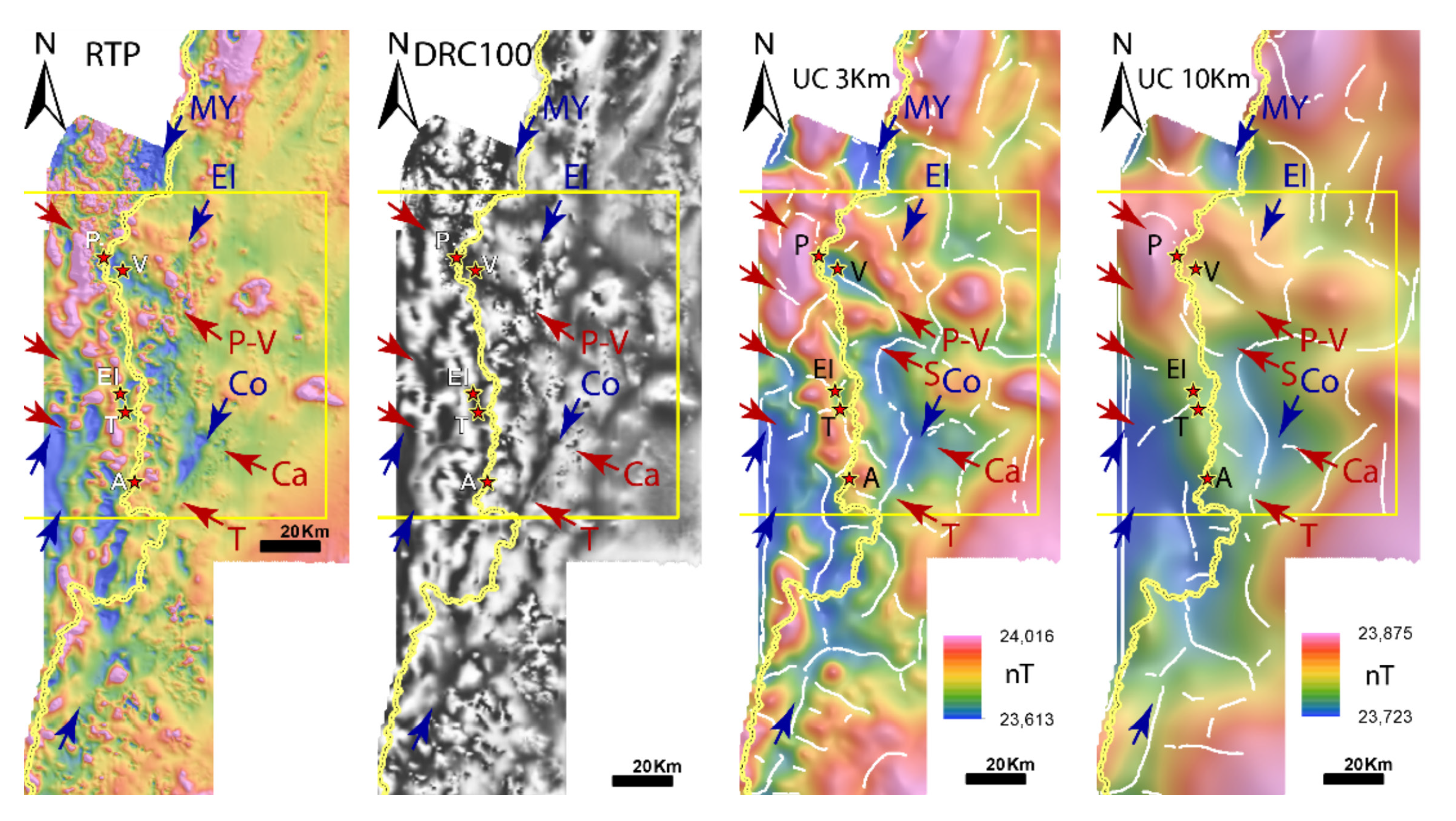
Figure 1. Different processing and enhancements on the EIB aeromagnetic surveys. RTP: Reduced to the pole. DRC: Dynamic Range Compression. UC: Upward continuation. Arrows show aeromagnetic lineaments, red correspond to NW-SE (P-V: Pascua-Veladero, S: Sancarron, Ca: Campana, T: Trapiche) and blue to NE-SW (MY: Molino Yaco, EI: El Indio, Co: Colangüil). Yellow box indicates EIB working area. Stars correspond to Au-Ag HS epithermal deposits within the belt (P: Pascua, V: Veladero, EI: El Indio, T: Tambo, A: Alturas). Yellow line is the international Chile-Argentina border.
The El Indio Belt is a 150 km2 metallogenic camp located in the Chilean-Argentinean Andes Cordillera. It hosts a resource of >45 Moz Au mostly in world-class Miocene Au-Ag epithermal deposits (Pascua-Lama, Veladero, El Indio-Tambo District and the most recent discovery Alturas). It provides a natural laboratory to study the trans-lithospheric architecture that acts as the pathway for magma/fluids/gold, and also the geodynamic evolution of the structural domains related to metallogenic events.
The project includes the reinterpretation of geophysical datasets (mainly aeromagnetometry, gravity and seismics) integrated with petrophysical data acquisition, as well as six months of surface structural mapping, all aimed to reveal the architecture of the El Indio Belt. This is coupled with cutting-edge techniques for zircon isotopic analyses, which have revealed the ancient nature of the El Indio Belt (see CCFS Annual Report, 2017 pp. 49-50) and the magmatic evolution associated with the metallogenic processes.
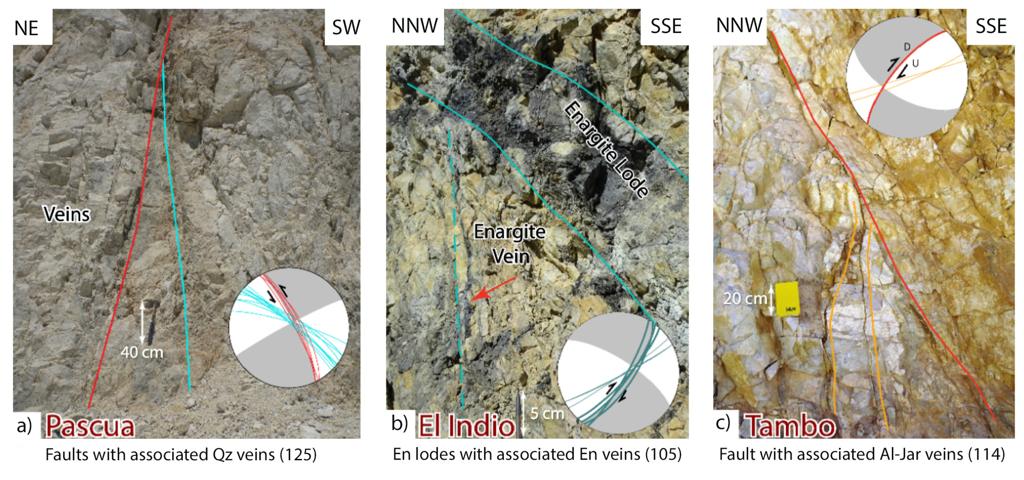
Figure 2. Altered and mineralised structures with kinematic indicators (tension veins and fractures) within the Miocene El Indio Belt (EIB), main Au-Ag deposits and minor prospects: a) Pascua fault with quartz (Qz) veins, b) El Indio enargite (En) lodes and veinlets, c) Tambo fault with alunite-jarosite (Al-Jar) veins. Numbers in parenthesis indicate station number.
Recent re-interpretation of the geophysical datasets has confirmed that the El Indio Belt is affected by a series of NW-SE- and NE-SW -ending structures that cross-cut the main N-S Andean trend. The Au-Ag deposits are located along the magmatic axis at the intersection of these structures, some of which penetrate at least 10 km into the crust (Fig. 1).
This deep-seated architecture has been corroborated in the field, where the NW-SE and NE-SW structures dominate in the areas within and around the deposits. These structures are ‘old’, traceable in the pre-Cenozoic basement, and may have originated during the Upper Triassic when they focused the intrusion of mafic dyke swarms trending in the same orientations. They have indeed persisted from the basement to the overlying Miocene magmatic arc which produced the epithermal Au-Ag deposits. The structural orientations obtained for the mineralising events recorded around the El Indio Belt indicate that these deposits follow those trends. Furthermore, they originated mainly in a strike-slip regime, with dextral movement occurring along the NE-SW and sinistral movement in the NW-SE structures (Fig. 2). The magmatic signature of the ore-bearing magmas, however, denotes they were originated in a compressive setting, carrying high La/Yb in whole rock (previously found by Bissig et al., 2001, IGR, 43: 4,312-340) as well as low εHf (‘crustal-type’ signature) associated with ‘mantle-like’ δ18O signatures in zircon (this project, Fig. 3). This confirms that the main metallogenic period in the El Indio Belt took place in a change from a highly compressive tectonic setting to a more strike-slip environment, as previously reported by Giambiagi et al. (2017, Tectonics, 36, 2714-2735).
The combination of a favourable architecture (NW-SE and NE-SW cross-arc structures), with a proper geodynamic trigger (transition from compression to strike-slip), and Au-fertile magmatic suites (possibly generated during the compression event), have all been found in the El Indio Belt. They confirm the mineral systems hypothesis in the area, and provide a valuable insight into one of the most important Au-mineralisation events within the Andes.
Figure 3. Age-εHfT signature for Cenozoic magmas of the EIB. Between Eocene and Oligocene, the εHfT is relatively constant. Since ~20 Ma there is a sustained decrease in εHfT values towards lower values in the syn-mineralisation magmas (red stars), during the Upper Miocene compression.
This project is part of CCFS theme 2, Earth’s Evolution, and contributes to understanding Earth’s Architecture.
Contacts: Constanza Jara, Marco Fiorentini
Funded by: Barrick Exploration, CCFS Flagship Program 2
Oblique crustal structural grain in the crust beneath the Phanerozoic Perth Basin
The Perth Basin is a nearly 1300 km long north-northwest trending basin, located along the south-western margin of the Australian continent, formed during the breakup of Australia and Greater India in the Permian to Early Cretaceous. Extension and trans-tension deformations during the rifting processes led to the formation of deep (up to 15 km) rift basins and structurally complex crustal structure.
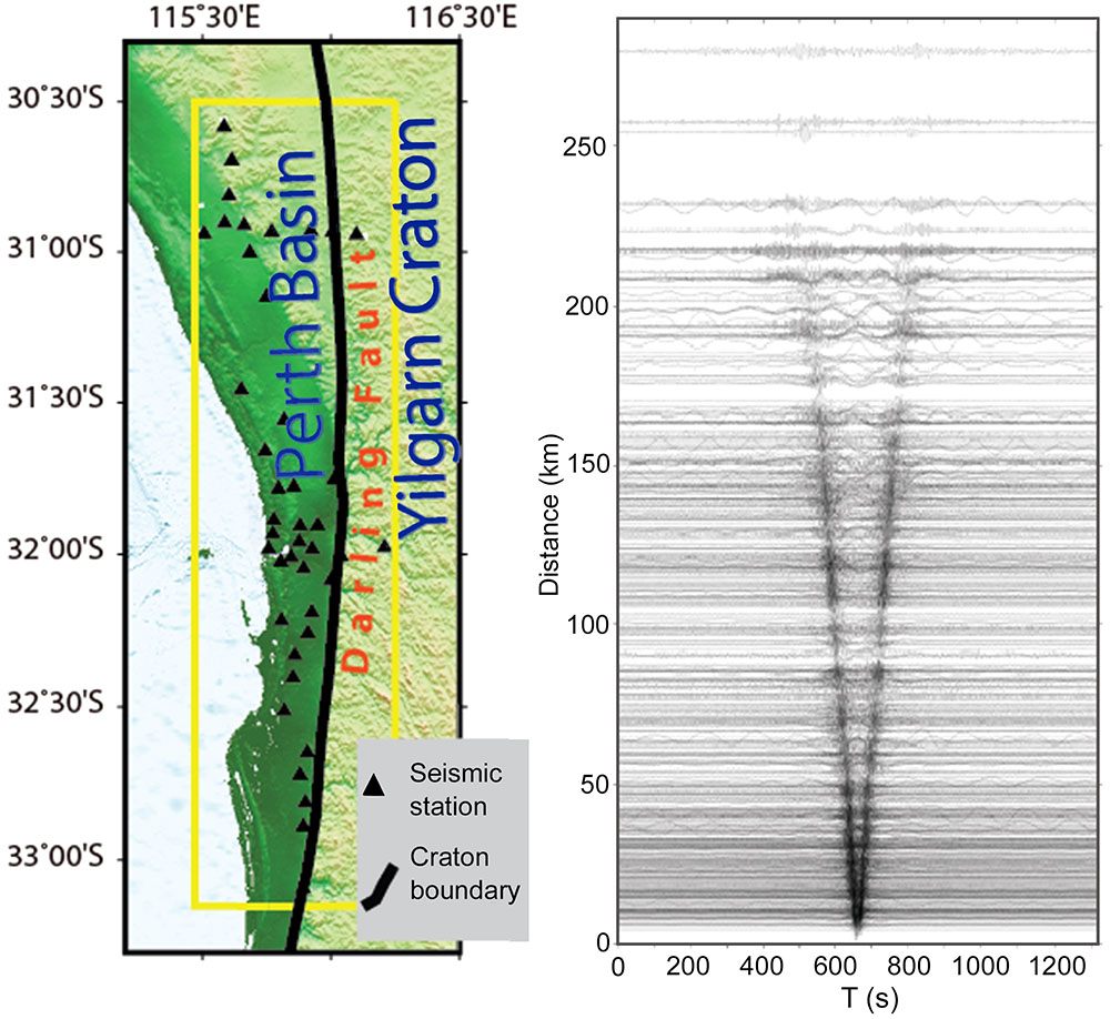
Figure 1. Perth Basin Seismic (PBS) array stations (left) and stacked cross-correlation functions (right) from ambient noise. Each trace shows equivalent surface wave signal traveling between a station pair. Craton boundary in the map is the Darling Fault separating at the surface the Yilgarn Craton (right) from the Perth Basin (left).
A 40-station 250 km long passive source linear array was deployed in 2017, to better define whole-crustal structural elements. The array is centred on the Perth Metropolitan region and is sub-parallel to the major structural boundary, the Darling fault, that separates the Yilgarn craton in the east. The array employed both 20-s and 120-s Trillium Compact sensors, operating variously from 6 months to a year to provide continuous recordings suitable for crustal receiver function and ambient noise analyses.
Here we present the crustal shear wave velocity model which was derived by applying a transdimensional inversion technique (Bodin et al., JGR 2012) to the dispersion group velocity dataset extracted using ambient noise (e.g. Yang et al., JGR 2008). The technique treats the number of velocity layers as a free parameter (i.e. transdimensional), and therefore can recover high-resolution layered velocity variations in the crust (e.g. see Yuan and Boding, Tectonics 2018, CCFS Contribution #1181).
In the modelling area, the first 10-km of the crust is mostly covered by the thick Phanerozoic basin. This is consistent with previous active source reflection profiles that show 10-12 km basin thickness south of Perth. At 15 km depth, however, two relatively high-velocity crustal structures may be recognised, separated by a NW-SE trending slow velocity zone. This trend is at a high angle to the NS-striking Darling Fault that separates the Yilgarn Craton (east) and the Perth Basin (west). The deep structural trend seems to continue further into the mid- to lower-crust, where our dataset (<28 s) quickly loses depth sensitivity.
Our results illustrate that passive-source seismology provides powerful means (in this case crustal tomographic imaging) to delineate deep crustal domains. An important finding of this study is the NW-SE trending crustal structure under cover. Intriguingly the trend is parallel to the large-scale NW-SE trending fault systems at the southwestern corner within the Yilgarn Craton. The results may shed light on the complex local tectonics and help us better understand the craton evolution along its southwest margin.
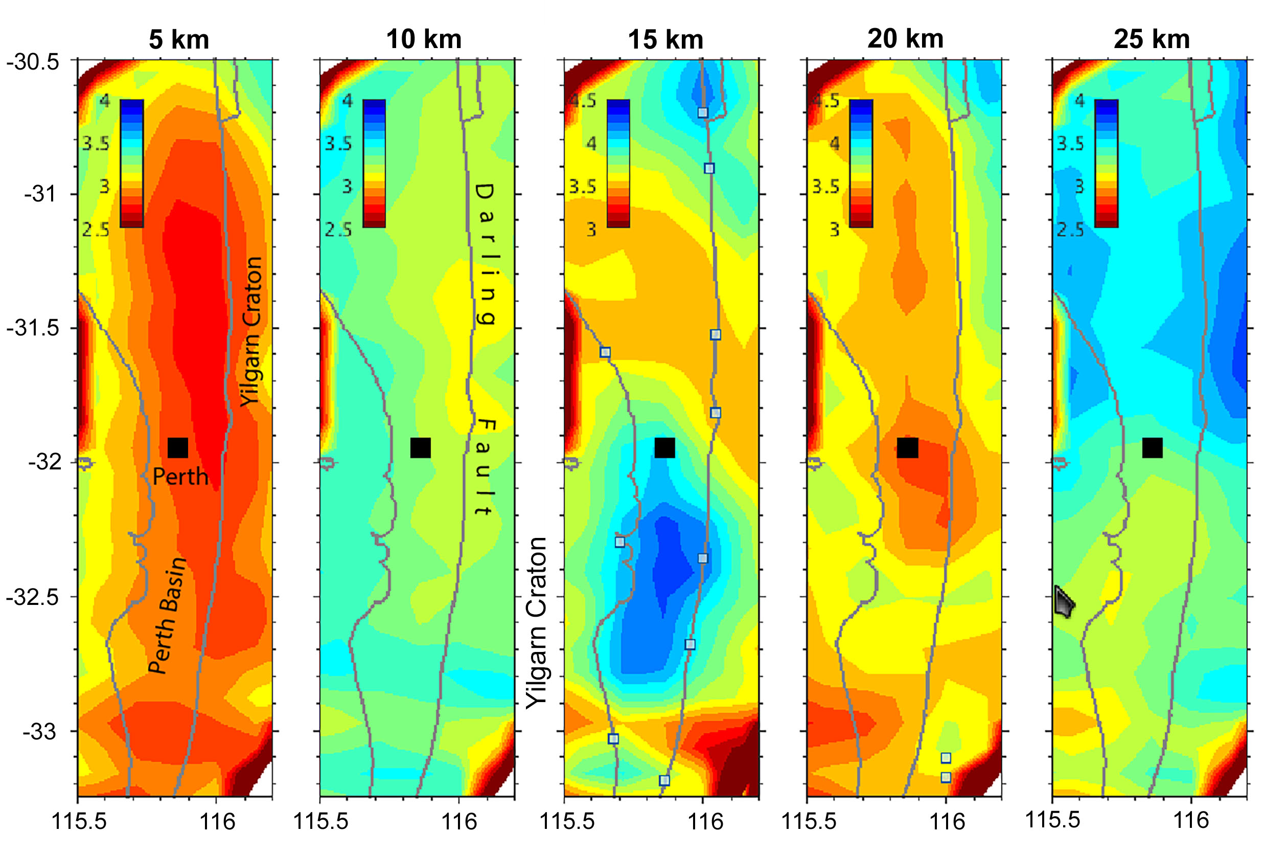
Figure 2. Map views of the shear-wave tomographic velocity model at various depths. Black square: Perth City.
This project is part of CCFS theme 3, Earth Today, and contributes to understanding Earth’s Architecture.
Contacts: Dr Xiangdong Lin (Beijing Earthquake Agency - visit sponsored by CCFS (2017-2018)), Huaiyu Yuan, Mike Dentith (GSWA), Simon Johnson (GSWA), Ruth Murdie (GSWA), and Klaus Gessner
Funded by: Perth Basin Seismic (PBS) project (UWA-GSWA)
A bigger tent for CAMP
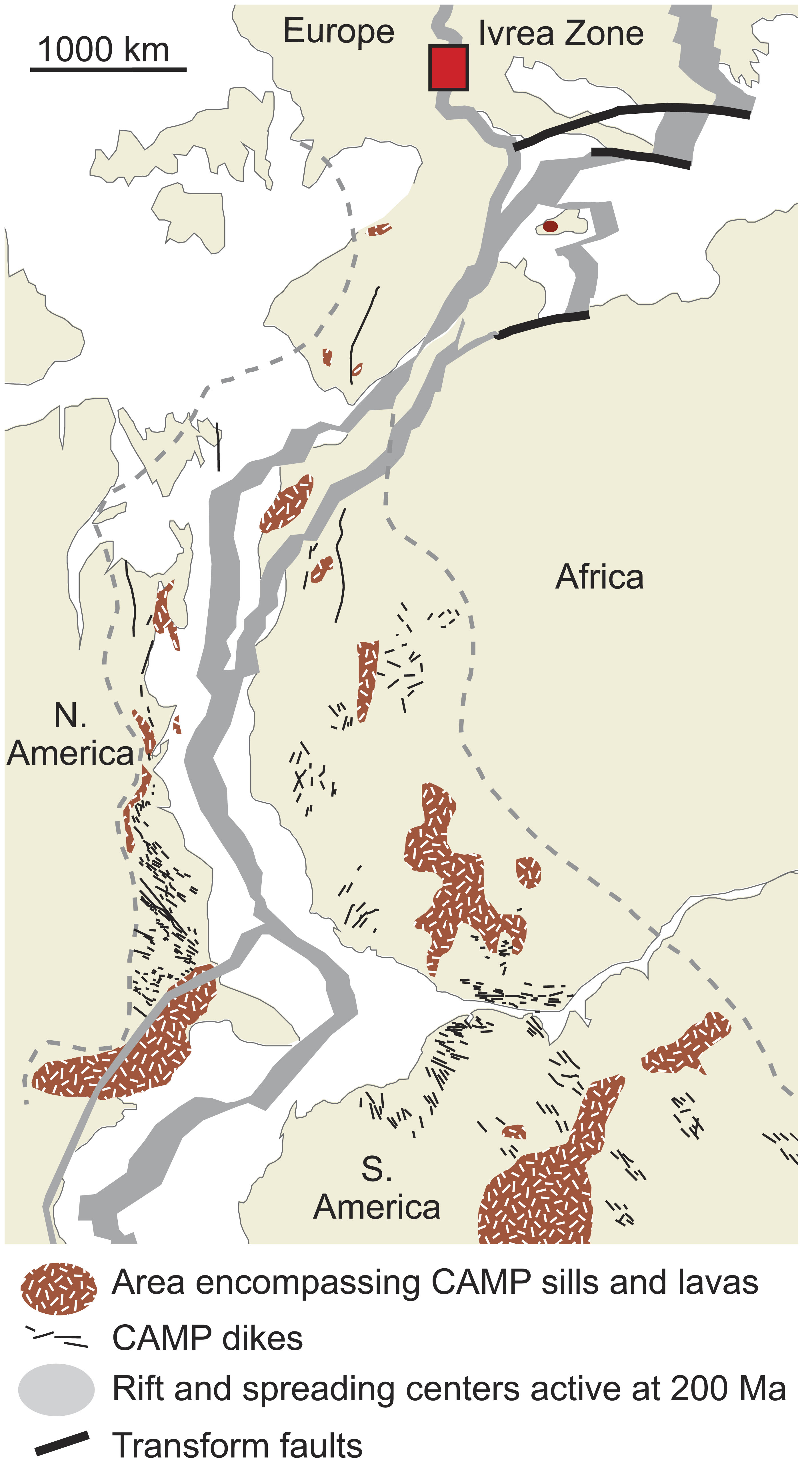
Figure 1. Reconstruction at ca. 200 Ma, with extent of intrusive and extrusive rocks of Central Atlantic Magmatic Province (CAMP) large igneous province (LIP). Star denotes location of La Balma-Monte Capio (LBMC) intrusion.
New high-precision geochemical and isotopic data show that magmas related to the Central Atlantic Magmatic Province (CAMP) were emplaced at the base of the continental crust in the Ivrea Zone of northwest Italy (Fig. 1). These results significantly extend the known footprint of one of the largest examples of a large igneous province (LIP) on the planet. The La Balma-Monte Capio intrusion ranges from dunitic at the base to plagioclase- bearing pyroxenitic at the top. Zircons were extracted from two samples at different levels and dated using the chemical abrasion-isotope dilution-thermal ionisation mass spectrometry (CA-ID-TIMS) U-Pb method. The two weighted-mean 206Pb/238U ages at 200.5 ± 0.3 Ma and 200.1 ± 0.5 Ma indicate a short-lived magmatic system that fractionated in place. The timing of emplacement is different from that of all other mafic-ultramafic intrusions in the Ivrea Zone and is consistent with magmatism associated with the CAMP. We suggest that exposure in the Ivrea Zone provides a unique glimpse into the presently unknown character of LIP magmas at the base of the continental crust, where the emplacement of this intrusion was facilitated by its location at a lithospheric suture. See CCFS publication #1188.
This project is part of CCFS theme 2, Earth’s Evolution, and contributes to understanding Earth’s Architecture and Fluid Fluxes.
Contacts: Marco Fiorentini, Steve Denyszyn
Funded by: CCFS Flagship Program 2
Langshan basalts record recycled Paleo-Asian oceanic materials beneath the northwest North China Craton
Crustal recycling is an important cause of mantle heterogeneity and can have significant control on basalt compositions. Recycled components from the subducted (Paleo-) Pacific slab have frequently been recognised in Cenozoic basalts from the eastern North China Craton (NCC). However, it still remains unclear if the subducted Paleo-Asian oceanic slab contributed to intraplate basalts in this Craton.
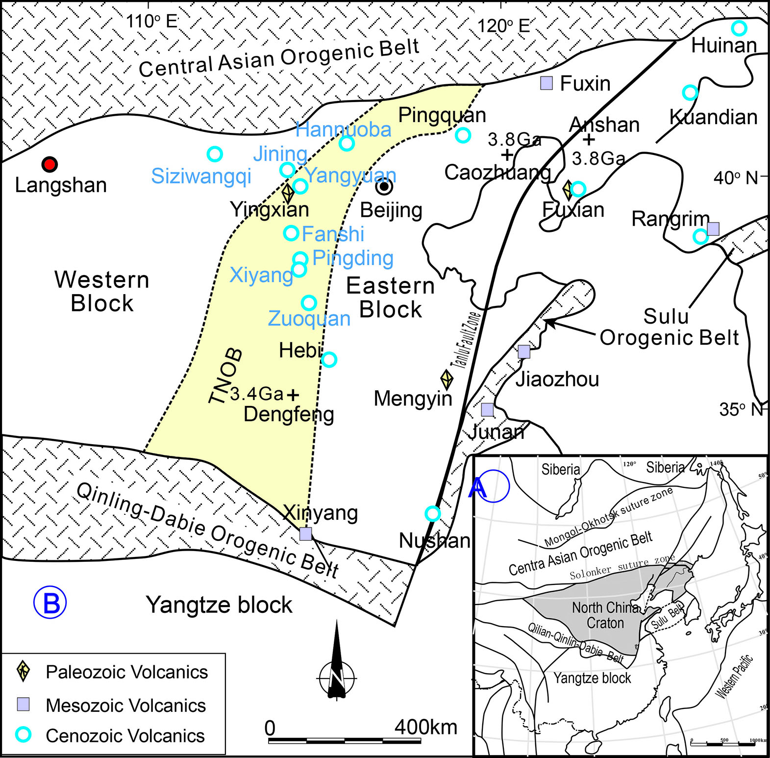
Figure 1. A) Simplified tectonic map of the North China Craton (Li et al., 2016). B) Tectonic sketch map of the NCC (Zhao et al., 2001, 2005; Kwon et al., 2009) with localities of mantle xenolith-bearing volcanics (Zheng et al., 2007; Yang et al., 2010; Xu et al., 2017; Dai et al., 2018). This craton is divided into eastern and western blocks with the Trans-North Orogenic belt in between according to Zhao et al. (2001). The compiled Cenozoic basalts in this study are from Siziwangqi and Jining in the western NCC, and Hannuoba, Yangyuan, Fanshi, Pingding, Xiyang, and Zuoquan in the TNOB. The term “northwest NCC” in this study refers to these localities and Langshan.
In a search of evidence for the recycled components from this slab, we have studied the Ar-Ar age, elemental and Sr-Nd-Pb isotope compositions of newly-discovered basalts from Langshan area and compiled a regional synthesis of Cenozoic alkali basalts from the northwest NCC (Fig. 1). This region is far from the Pacific domain but near the suture zone of the Paleo-Asian Ocean. With a Late Cretaceous eruption age (~89 Ma), Langshan basalts (Fig. 2) have low silica and high FeO, MgO and alkali contents, high incompatible elemental concentrations, positive Sr, Eu, Ba, Zr, Hf, Nb, Ta and negative Pb and Ti anomalies with subducted oceanic crust-like Ce/Pb, Nb/U, Rb/Sr and Ba/Rb ratios, superchondritic Zr/Hf ratios, and uniform radiogenic isotopes (εNd(t) = 2.32~2.64, 87Sr/86Sri = 0.703796~0.704340, 206Pb/204Pbi = 18.601~18.828, 207Pb/204Pbi = 15.489~15.536, 208Pb/204Pbi = 38.527~39.000). These compositional characteristics are shared by the compiled Cenozoic alkali basalts from northwest NCC.
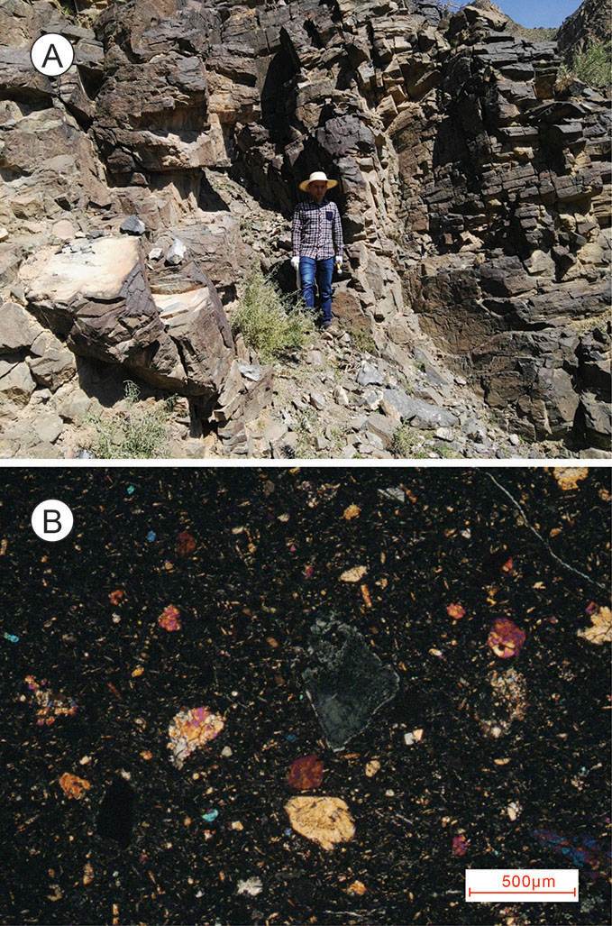
Figure 2. Field outcrop A) and microphotograph B) of the Langshan basalts. The man in A) is ~ 1.7 metres tall.
The low silica and high MgO, FeO and alkali contents together with the positive Zr, Hf, Nb, Ta and negative Ti anomalies probably reflect silica-deficient garnet pyroxenites in their mantle source. The high Nb/U and Ce/Pb ratios and unradiogenic isotopes together with P-T estimates (P = ~2.5 GPa, Tp = 1300~1450 °C) collectively suggest an asthenosphere origin. The positive Sr, Eu, Ba, Zr, Hf, Nb, Ta anomalies and the canonical indices (high Ce/Pb, Nb/U and low Rb/Sr and Ba/Rb ratios) indicate the involvement of a subducted oceanic igneous slab. Considering 1) the particular tectonic setting of the study region (Fig. 1), 2) the inferred northward increase of silica-deficient pyroxenite in the mantle source of Cenozoic alkali basalts, 3) the evidence for strong lithospheric modification beneath the northwest NCC induced by slab-derived components, and 4) the longevity of subducted slab in convection mantle, the subducted Paleo-Asian oceanic materials could have introduced ubiquitous mantle heterogeneity beneath the northwest NCC and have played a significant role in generation of the Late Cretaceous to Cenozoic intraplate alkali basalts there.
This project is part of CCFS theme 2, Earth’s Evolution, and contributes to understanding Earth’s Architecture and Fluid Fluxes.
Contacts: Hong-Kun Dai, Jian-Ping Zheng, Sue. O’Reilly, Bill Griffin, Qing Xiong, Rong Xu, Yu-Ping Su, Xian-Quan Ping, Fu-Kun Chen
Funded by: National Key R&D Program of China (2016YFC0600403), NSFC (41520104003), CSC (201706415070), iMQRES, Outstanding Doctoral Dissertation of CUG, IGCP 622
Carmeltazite - The latest Mt Carmel sensation
One of the most common exotic phases in the ultra-reduced assemblages from Mt Carmel (see Research highlight Holy hibonite! - ‘meteoritic’ mineral assemblages in volcanic rocks), Vanadium melts reflect Earth’s most reducing conditions, Moissanite in the lithospheric mantle: Crystallisation from metallic melts) has now been recognised as a new mineral by the International Mineralogical Association. Carmeltazite has the idealised chemical formula ZrAl2Ti4O11 and is named after the locality (Mt Carmel) and its dominant elements (Titanium, Aluminium and Zirconium).
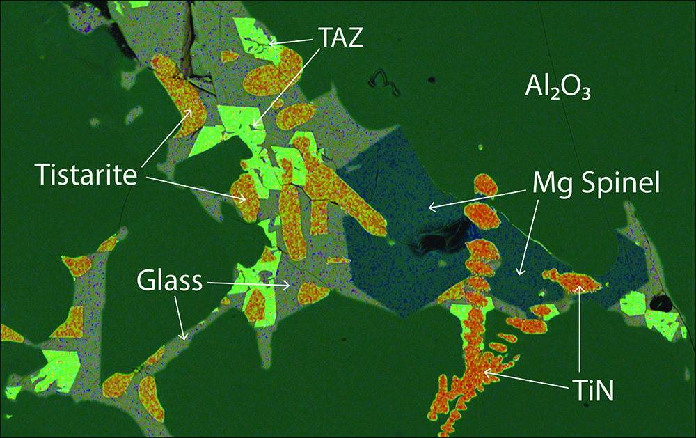
Figure 1. A typical melt pocket trapped in skeletal crystals of corundum (Al2O3). Euhedral crystals of carmeltazite (TAZ) surround locally resorbed crystals of tistarite (Ti2O3), set in a CaO-Al2O3-MgO glass. Image is 400 microns wide.
These unique mineral assemblages crystallised in melt pockets trapped in aggregates of corundum crystals (Carmel SapphireTM) found among the ejecta of small Cretaceous pyroclastic volcanoes on Mt Carmel. They are believed to have been crystallising in magma pockets trapped near the crust-mantle boundary, when they were entrained in basalts erupting from much deeper levels.
Carmeltazite typically crystallises after the earliest phases, tistarite (Ti2O3), TiN and spinel ((Mg,Ti)(Al,Ti)2O3)) (Fig. 1). The assemblage is unusual on Earth, because Ti is present as Ti3+ instead of the common valence, Ti4+, reflecting conditions in which oxygen fugacity lies 6 log units below the Iron-Wustite buffer (fO2= ΔIW -6) (see Research highlight Holy hibonite! - ‘meteoritic’ mineral assemblages in volcanic rocks, Moissanite in the lithospheric mantle: Crystallisation from metallic melts). Carmeltazite appears to crystallise at the expense of tistarite, but since both phases contain Ti3+, there is no obvious change in fO2 driving the crystallisation sequence. It is more likely that the crystallisation of tistarite and spinel served to further concentrate Zr to a critical level, leading to precipitation of carmeltazite.
Figure 2. Structure of carmeltazite.
Single-crystal X-ray diffraction studies were performed at Universita degli studi di Firenze, Italy, on fragments extracted from polished sections. The structure (Fig. 2) is orthorhombic, with space group Pnma. The refined X-ray formula can be written as (Ti3+3.75 Al1.94 Zr0.85 Mg0.22 Si0.14 Sc0.04 Ca0.03 Y0.02 Hf0.01)Σ=7.00 O11, in excellent agreement with that obtained from electron microprobe: (Ti3+3.60 Al1.89 Zr1.04 Mg0.24 Si0.13 Sc0.06 Ca0.05 Y0.02 Hf0.01)Σ=7.04 O11.
Over 130 different phases have thus far been recognised in the Carmel SapphireTM provided by Shefa Yamim Ltd for this research. Most of these have not been found previously in Nature, and they will continue to provide insights into the evolution of this remarkable mineral system. See CCFS publications #830 and 1229.
This project is part of CCFS theme 2, Earth’s Evolution, and contributes to understanding Earth’s Fluid Fluxes.
Contacts: Bill Griffin, Luca Bind (University of Florence), Fernando Camara (University of Milan)
Funded by: CCFS
Putting the spin on Australia: First Precambrian palaeomagnetic data from the Mawson Craton (East Antarctica)
East Antarctica has been a key piece in Precambrian palaeogeographic reconstructions. As one of the most effective methods used to reconstruct supercontinents, palaeomagnetic studies have encountered great difficulties in East Antarctica due to inaccessibility, limited outcrops, and difficulties in conducting fieldwork in the Antarctic. There are only two Precambrian palaeomagnetic poles available from East Antarctica: the ca. 1130 Ma “BM” pole from the Borgmassif intrusions in Dronning Maud Land and the ca. 1100 Ma “CL” pole from Coats Land (Fig. 1). However, it is likely that neither the Dronning Maud Land nor Coats Land terranes joined the Mawson Craton until the final assembly of Gondwana at ca 520 Ma. Therefore, the BM and CL poles cannot be used to constrain the location of the Mawson Craton in pre-530 Ma palaeogeographic reconstructions. Additionally, for much of Precambrian time, the Mawson Craton is thought to have been a part of Australia, connected to the Gawler craton, which also lacks reliable pre-800 Ma palaeomagnetic constraints. We conducted a pilot palaeomagnetic study on the ca 1134 Ma Bunger Hills dykes of the Mawson Craton. Of the six dykes sampled, three gave meaningful results providing the first well-dated Precambrian palaeopole at 40.5°S, 150.1°E (A95 = 20°) for the Mawson Craton.
Figure 1. Tectonic map of Australia and Antarctica in a Gondwana configuration. Antarctica is rotated to Australia coordinates using a Euler pole7 at 1.3°N, 37.7°E, rotation = 30.3°. Abbreviations: AFO, Albany-Fraser Orogen; BH, Bunger Hills; CCr, Curnamona Craton; M-F-C, Madura-Forrest-Coompana Provinces; MR, Miller Range; NC, Nornalup Complex; TA, Terre Adélie craton; WI, Windmill Islands; WL, Wilkes Land.
Although it is generally agreed that Precambrian Australia (west of the Tasman line; Fig. 1) is composed of three Archaean to Palaeoproterozoic cratons (the West, North, and South Australian cratons - WAC, NAC and SAC respectively), when and how the present-day configuration took form is still a matter of debate. In an effort to reconcile some mismatching coeval poles of Australia, Li & Evans (2011, Geology) proposed that WAC + SAC (with Mawson) rotated ~40° relative to the NAC at ca 650-550 Ma to form the Precambrian part of Australia as we know it today (Fig. 1). Our new pole and the coeval Lakeview Dolerite pole make up another group of coeval poles from the NAC and WAC + SAC + Mawson, respectively, with which the intraplate rotation may be further tested. With the rotation applied, the area of overlap of the 95% confidence circles of the BHD and LD poles increases (Fig. 2), which constitutes a positive test for the relative rotation between WAC + SAC (+ Mawson) and NAC. The vast intracratonic rotation hypothesis not only reconciles discrepant coeval palaeopoles, but also provides a mechanism for the enigmatic Paterson and Petermann orogenies that account for significant mineralisation such as the massive Telfer Au deposit.
This project is part of CCFS theme 2, Earth’s Evolution, and contributes to understanding Earth’s Architecture.
Contacts: Yebo Liu, Zheng-Xiang Li, Earth Dynamic Research Group, Curtin University
Funded by: ARC Laureate Fellowship (ZX Li), Australian Antarctic Science Project 4191
Figure 2. Four groups of coeval poles from the WAC + Mawson and NAC plotted in Mercator projection. Mawson (Antarctic Part) rotated to SAC in its Gondwana configuration using a Euler pole at 1.3°N, 37.7°E, rotation = 30.3°. (a) Australia in its present-day configuration; (b) WAC + SAC + Mawson rotated to NAC about a Euler pole at 20°S, 135°E, rotation = 40°. Poles from the NAC: EP - Elgee-Pentecost Formations; LD - Lakeview dolerite; ADS - Alcurra dykes and sills; JC - Johnny’s Creek Member (Bitter Springs Formation); WTC - Walsh Tillite Cap Dolomite. Poles from WAC + SAC + Mawson: HP2 - Hamersley Overprint 2; BHD - Bunger Hills dykes; BBS - Bangemall Basin sills; MDS - Mundine Well dyke.
Sorting the wheat from the chaff in the source of Australian lamproites
Olivine is the main mineral in the Earth’s upper mantle, but because of its very simple composition, it has been considered historically as being of little use as a tracer of mantle and magmatic processes. This has changed with recent advances in the analysis of minor and trace elements, which have made the low amounts of trace elements accessible by high-precision electron microprobe and Laser ablation-ICP-MS.
As a result, minor and trace elements in olivine are used increasingly to identify the rocks present in the source, namely whether these are dominantly peridotite or contain significant amounts of other rocks, including material recycled into the mantle at subduction zones. Kimberlites are magmatic rocks with the deepest known origins (200-250 km), and a healthy debate has arisen recently as to how much of the olivine carried by them crystallised from the kimberlite melt and how much is entrained mantle material that may be related to part of the source.
Figure 1. Main petrographic features of West Kimberley lamproite olivines. X-ray map (Fe Kα at 15 kV) of olivine xenocryst showing narrow reversely zoned rim.
The next deepest magmatic rocks are diamond-bearing lamproites, of which those of the Kimberley region of Western Australia (the name match is merely coincidental) are prime examples. We have investigated olivines from these lamproites and find many to have homogeneous cores with rims that crystallised at a late stage from the rising melt (Fig. 1).
Phenocrysts - crystals that form directly from the melt - commonly show increasing Ca and Mn and decreasing Cr and Ni towards the rims. Xenocrysts - the entrained mantle material - are overgrown by rims of similar composition to all other rims. These rims are magnesium-rich (Mg# 91-92) and have compositions that show they formed from melts with 22-24 wt% MgO.
The xenocrysts are pieces of garnet peridotites from 115-190 km depth and show consistent variations in minor and trace element abundances with temperature and pressure of origin. The olivines from the deepest levels of the lithosphere have more Na, Al, P, Ti and Zr than shallower ones. This indicates that the mantle is more strongly depleted at shallower depths by previous melt loss, presumably in the first half of Earth history. However, this does not mean that this has always been the case: it is more likely that these shallower upper mantle levels escaped re-enrichment by later melts from below because the rising melts get stuck in the lower lithosphere.
Previous Pb isotope studies have shown that subducted sedimentary material was probably involved in the source of the West Kimberley lamproites. Our earlier studies of Mediterranean magmatic rocks showed that the presence of crustal material in the source is often flagged by the enrichment of lithium in olivines. However, we found that olivines in the West Kimberley lamproites are not enriched in lithium, which is thought to be due to its later loss in fluids or by diffusion during the long time period (around 2 billion years) between subduction and production of the lamproites in the relatively recent past. See CCFS publications #1248.
This project is part of CCFS theme 2, Earth’s Evolution, and contributes to understanding Earth’s Fluid Fluxes.
Contact: Bill Griffin
Funded by: CCFS Flagship Program 1
Reaction of subducted marine sediment with peridotite produces saline fluid inclusions in diamonds
Diamonds form in Earth’s mantle at depths of greater than 150 km and are carried to the surface by volatile-rich magmas, the so-called kimberlites. Most of the non-gem quality and some gem-quality diamonds carry inclusions of other minerals or fluid phases. Commonly, the fluid inclusions are highly saline and carbonate-rich. They were previously explained as a proof of the recycling of sea-water to Earth’s mantle within marine sediments and oceanic crust. However, the mechanism of their transport into the mantle remained unresolved.
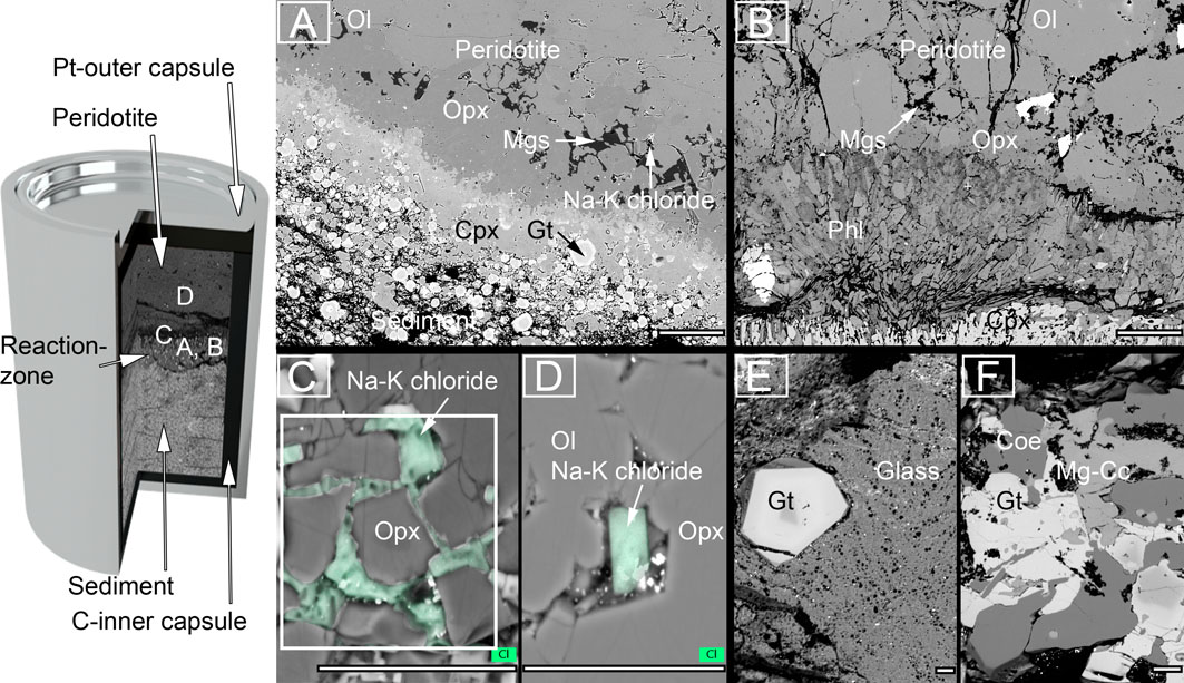
Figure 1. Backscattered electron images of experimental charges. Locations of images A-D from sediment-peridotite reaction experiments are schematically shown in capsule on left. A, C, D: reaction experiments at 5 GPa/1000 ºC with superimposed EDX maps of chlorine (green in C, D). The sediment half of two-layer experiments recrystallised to garnet and clinopyroxene, whereas orthopyroxene, magnesite (Mgs) and Na-K chlorides formed at the leading edge of the reaction zone against the peridotite. B: Peridotite layer in reaction experiment at 3 GPa/900 °C contained phlogopite behind the magnesite + orthopyroxene zone, and Na-K chlorides were absent. E, F: sediment melting experiment (no peridotite included) at 4 GPa/1000 °C showing silicate melt (E) in equilibrium with garnet, coesite, and mg-calcite shown in (F). Scale-bar in A, B = 100 µm and C, D, E, F = 20 µm.
In this study, we melted oceanic sediment and reacted it with dunite in a 2-layer arrangement (Fig. 1) at pressures corresponding to depths of 90-180 km, where the sediment layer recrystallised to garnet and clinopyroxene (Fig. 1, A and B). The experiments also produced a reaction zone between the two rock types; in experiments at pressures at and above 4 GPa these reaction zones contain Na-K chlorides (Fig. 1, A, C, and D, Fig. 2). Most of the analysed chlorides contain 5-15 wt% Na and 30-45 wt% K, with K/Na ratios between 2 and 9 (Fig. 3).
In contrast, all reaction experiments at 3 GPa and the higher-temperature experiment at 4 GPa/1100 °C, as well as a sediment-melting experiment at 4 GPa/1000 °C are devoid of chlorides. In these experiments, potassium and sodium are contained in phengite, Mg-rich mica (phlogopite), and melt (Fig. 1, B, E, and F).
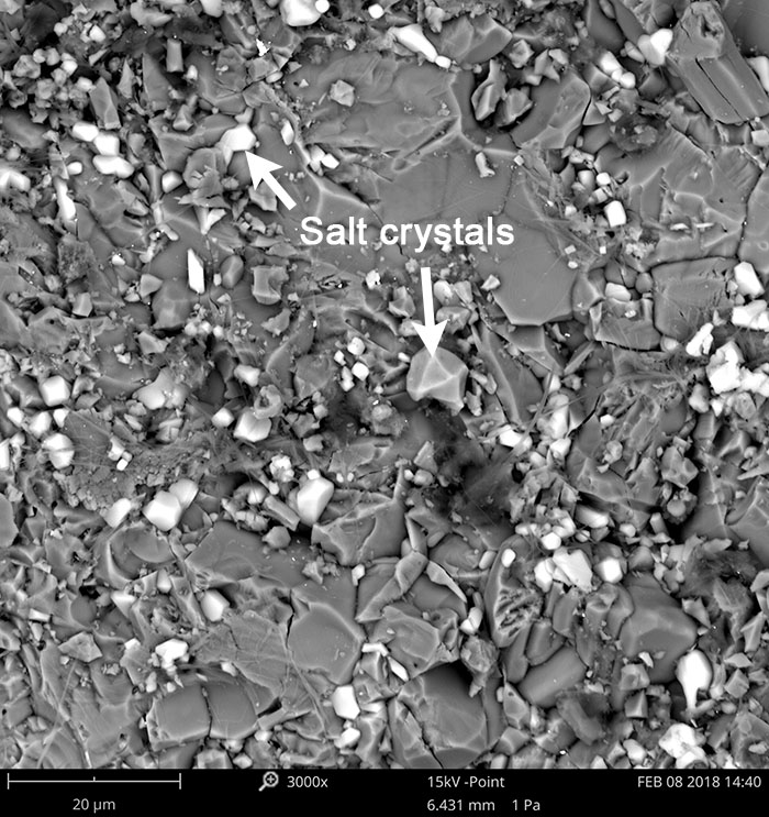
Figure 2. Secondary electron image of unpolished capsule showing idiomorphic salt crystals embedded in garnet and clinopyroxene.
The crystallisation of Na-K chlorides is induced by the reducing conditions in the inner graphite capsule and a shift in fluid species which consumes H2O following the reactions: (1) CH4 + H2O = 3H2 + CO and (2) 2CO = C + CO2 (the CCO buffer).
Any oxygen fugacity (fO2) equal to or below CCO will lead to chloride precipitation from an oversaturated solution: Na/K+(aq) + Cl-(aq) = (Na,K)Cl. Since the dehydration of the fluid (reaction (1)) is only observed in reaction experiments at >3 GPa, the sequence leading to chloride precipitation has to be as follows: (1) melting of the sediment and reaction with dunite, (2) total consumption of the melt phase by anhydrous phases (garnet and pyroxene) which drives all H2O into a fluid phase, and (3) dehydration of the fluid by reaction (1) and precipitation of chloride from a fluid saturated in K, Na and Cl, and precipitation of carbon as graphite or diamond by reaction (2). If fO2 is above CCO, Na-K chlorides will not precipitate, but instead be dissolved in highly saline hydrous fluids. The absence of hydrous crystalline phases such as mica in all chloride-bearing experiments is probably a direct result of the depletion of the fluid in H2O.
Our results show that salt is a stable solid phase in the mantle below 110 km. The composition of the salts that form during the experiments are identical to the saline fluid inclusions in diamonds. We demonstrate that the processes that lead to the growth of salt and diamond crystals are driven by the recycling of oceanic sediments at subduction zones. The reaction products of our experiments also contain Mg-rich carbonates such as magnesite, which are necessary ingredients for the formation of kimberlite magmas that transport diamonds to Earth’s surface.
This project is part of CCFS theme 3, Earth Today, and contributes to understanding Earth’s Fluid Fluxes.
Figure 3. K/Na ratios of experimental chlorides and saline micro-inclusions in diamonds. Most saline micro-inclusions (orange diamonds) have a K/Na ratio between 1 and 9, similar to the ratios found in the experimental Na-K chlorides of this study (grey diamonds).
So when is a date not an age? This is an ongoing dilemma in U-Pb zircon geochronology and has led to a series of protocols being developed to potentially address this vexed question. But what if, even after doing all the ‘correct’ things, you find that your date does not record the age of crystallisation? This is something that has been brought into clear focus in a recent paper published by our group (Ge et al., Geology, 46, 303-306, 2018).
But let us step back for a moment and briefly review the background to this problem; one that we have been working on since the inception of the CCFS. It had long been known that zircons in certain rocks can show reverse discordance, i.e. the result of either Pb gain or U loss (see CCFS publication #738, Kusiak et al., PNAS, 112, 4958-4963, 2015 for a recent summary of this phenomenon). This appeared to be more prevalent when using secondary ion mass spectrometry (SIMS) techniques than either thermal ionisation mass spectrometry (TIMS) or laser ablation inductively-coupled mass spectrometry (LA-ICP-MS). During our re-investigation of high-grade gneisses from the Napier Complex in Antarctica it was evident, utilising the scanning ion-imaging capacity of a CAMECA IMS 1280, that radiogenic Pb had been locally mobilised and concentrated into micron- and nano-scale clusters. Further work using transmitted electron microscopy (TEM) established that, for the Napier Complex zircons, the Pb was concentrated into nanospheres of metallic Pb. The small size of these clusters, also established in related studies utilising atom probe tomography (APT), explains why this phenomenon was largely only detected by SIMS analyses, since the analysed volume is considerably smaller using this technique. Mobility of Pb within zircon thus has the potential to affect the veracity of dates obtained from crystals showing this feature. However, it was generally considered that, owing to the small size of the clusters, their low concentration in areas showing this phenomenon, and their overall irregular distribution within the zircon crystals, that they were unlikely to have a major effect on the U-Pb ages obtained from such grains. It also appeared to be a feature affecting mainly high-grade gneisses that had undergone intense metamorphism and was therefore not a ‘mainstream’ issue. Notwithstanding this view, since a large proportion of the oldest rocks on Earth are high-grade gneisses, it was evident that this needed to be carefully investigated. Figure 1. Site of SIMS analysis with date of 4468 ± 11 Ma (2s), obtained on surface 2, projected onto scanning ion image of 206Pb obtained on surface 5. The line A-B-C is a profile along which individual U and Pb isotopes were counted (see Ge et al., 2018 for details). The lighter areas in the figure indicate an increased Pb content.
The largest known inventory of Hadean zircons in the world resides in a conglomerate unit in the Jack Hills belt of Western Australia. Hence, this was the obvious place to see if Pb mobility was present and, if found, to test its nature and significance on the oldest ages recorded from Earth. A total of ~2500 detrital zircon grains were extracted from a sample collected at the original W74 discovery site and a large proportion of these was analysed rapidly by SIMS in order to identify Hadean crystals. From 215 identified Hadean crystals, a suite of 51 grains was finally selected as representing the most pristine grains based on multiple U-Pb SIMS dating, their lack of imperfections and inclusions, and magmatic features evident in cathodoluminescence (CL) imaging. One crystal (grain 14041) proved to be a stand-out. It recorded a concordia 207Pb/206Pb date of 4463 ± 17 Ma (2σ), the oldest zircon ‘age’ ever recorded from Earth. This was established using multiple analyses and by re-polishing and re-analysing the same site. Indeed, a total of six dates revealed a range from 4486 ± 17 to 4425 ± 55 Ma (1σ): it met all the criteria for being an acceptable age for crystallisation of that zircon. However, knowing the potential for Pb mobilisation, it was imperative to test if this had affected grain 14041. Scanning ion imaging revealed a highly-significant phenomenon not previously recorded from zircon; an approximately 20-micron concentration of radiogenic Pb (Fig. 1). Fortuitously, the SIMS site had been placed exactly over this circular zone of Pb-enrichment. Additional analyses and modelling established that the actual age of zircon grain 14041 was significantly younger at between 4.32 and 4.27 Ga, consistent with the 4277 ± 16 Ma (2σ) concordia age recorded by the majority of SIMS analyses in that crystal. So what are the salutary lessons to be taken from this study? Firstly, it highlights that even concordant U-Pb ages can be spurious and up to 200 Ma older than the actual crystallisation age. This is an important finding, because dating the oldest zircons has major implications for crustal evolution on Earth, other terrestrial planets and the Moon. Secondly, it indicates the need to not only take multiple ages from the same zircon domain identified in CL images, but to also test this further by undertaking either scanning ion imaging or atom probe tomography to validate the findings. Finally, although Pb mobility has now been established in zircon in several parts of the world and in a variety of host rocks, the mechanism(s) remains elusive and is the subject of our ongoing investigations. This project is part of CCFS theme 1, Early Earth, and contributes to understanding Fluid Fluxes.
The base of the cratonic lithosphere varies in its lithology: it consists mostly of highly depleted harzburgite as well as progressively modified metasomatised lherzolite, related to melt metasomatism. Melts rich in C, H and O originate from the underlying convecting mantle; they can infiltrate the cratonic lithosphere, where they are important in diamond formation and refertilisation (~150-200 km depth). These low-volume incipient melts can exist over a large temperature range (~300°C) in the upper mantle before major melting begins. They can form in reduced conditions dominated by CH4 + H2O volatiles, or in oxidised conditions with hydrous carbonatitic affinity (CO2 + H2O). Figure 1. Hidden processes caused by redox freezing. The bottom of the depleted, reduced cratonic lithosphere is exposed to the infiltration of oxidised (CO2-H2O) silica-poor incipient melts (like ultramafic lamprophyre). Redox freezing forms a diamond-bearing eclogitic assembly. Remaining reactive hydrous melt infiltrates further into the cratonic lithosphere, forming dunites by consuming pyroxenes and precipitating Fe-richer olivines. The hybridisation reaction finally deposits the remaining melt as garnet-bearing wehrlite veins with adjacent Fe-rich olivines.
Our experiments focused on the redox freezing of oxidised incipient melts as they encounter reduced depleted harzburgite at the bottom of the cratonic lithosphere. As oxidised incipient melts (predominantly CO2 - H2O) are unstable in the reduced cratonic lithosphere, reaction with surrounding mantle is inevitable and will result in the reduction of carbonate. The result is precipitation of diamond by a process known as ‘redox freezing’. Redox freezing deposits diamond in a reaction (CO2 = C + O2) that forms clinopyroxene-rich (omphacitic clinopyroxene, grossular-rich garnet) reaction zones (Fig. 1), in which mineral compositions are similar to those in eclogitic mantle xenoliths (Fig. 2).
The remaining reactive, hydrous and low-silica melt migrates further into the depleted reduced craton and consumes pyroxenes, precipitating olivine that is richer in Fe than in surrounding peridotites. The melt progressively increases its silica content by this process, becomes more ‘oxidised’, and finally precipitates hybrid, alkali-rich wehrlite veins with omphacitic clinopyroxenes and pyrope-rich (grospyditic) garnets similar to ‘type A’ eclogites (Fig. 1, 2). The formation of such eclogites has previously been explained by high-pressure metamorphic transformation of subducted oceanic crust, or by recrystallisation of high-pressure cumulates from mantle-derived melts. In contrast, the redox freezing of alkaline, silica-undersaturated ultramafic lamprophyre-like incipient melts forms a diamond-bearing ‘type C’ eclogitic assembly (also classically explained as subduction-related eclogites). Further hybridisation reactions precipitate the enigmatic ‘type A’ wehrlite veins, usually linked to the crystallisation of more mafic (Mg-rich) melts in cratons. The redox reactions between reduced depleted cratonic rocks and infiltrating oxidised melts is more complex than previously assumed, and results not only in different types of bimineralic eclogitic rocks, but also in dunitic rocks (olivine with very minor pyroxenes) without high-degree melting of the cratonic lithosphere. Figure 2. Ternary plot of mineral and rock compositions (defined by Mg + Fe, Ca + Na and Al + Cr) showing the complex nature of the redox freezing. Mineral end members for clinopyroxene and garnet are shown (diopside-omphacite, grossular-pyrope). Depleted, reduced harzburgite minerals are shown in black symbols. The reaction first precipitates grossular-rich garnets and omphacitic clinopyroxenes, proceeding to pyrope-rich garnets and Mg-rich omphacitic clinopyroxenes. Type A-B-C eclogites from Jacob 2004, Lithos 77, 295-316, diamond inclusions from Kiseeva et al., 2013, Geology 41 (8): 883-886.
This project is part of CCFS themes 2 and 3, Earth’s Evolution and Earth Today, and contributes to understanding Earth’s Architecture and Fluid Fluxes.
The redox state of Earth’s mantle is a critical parameter in Earth processes, controlling the speciation of fluid and solid phases. The occurrence of moissanite (SiC) as xenocrysts in mantle-derived basaltic and kimberlitic rocks is a paradox in terms of the redox conditions of the mantle, since SiC can crystallise and remain stable only at ƒO2 <∆IW-6 (6 log units below the Iron-Wustite buffer) while the ƒO2 of the lithospheric mantle is commonly considered to be much more oxidised (ƒO2 ≥∆IW-0).
Figure 1. Moissanite grains from Mt Carmel, Israel. Moissanite grains (Fig. 1) have been recovered from alkali basalts and related alluvial deposits at Mt Carmel, northern Israel, and from the Udachanaya and Aikhal kimberlites in Siberia. Most grains are fractured, but some partly preserve crystal faces. Grains from Mt Carmel are generally 0.5-2.0 mm in diameter, and range from black, blue, bluish-green to colourless. The Siberian samples are typically 0.4-1.0 mm in diameter; most are colourless, and some are bluish-green. 3D-CT scans of SiC grains reveal solid inclusions and elongated cavities; both tend to be aligned parallel to the c axis of the host crystal. Some cavities are associated with inclusions, but others are not. The inclusions in SiC (Fig. 2) typically have round to oval shapes, but some have straight boundaries, constrained by the crystal structure of the host grain, suggesting they were entrapped as melts. Each inclusion contains two or more phases with or without cavities. Native Si (Si0) is usually the main phase and is always associated with one or more silicide phases, Si + Fe3Si7 ± FeSi2Ti ± CaSi2Al2 ± FeSi2Al3 ± CaSi2. The existence of cavities suggests the former presence of a volatile phase during SiC crystallisation. These observations suggest that SiC crystallised in the lithospheric mantle from metallic melts (Si-Fe-Ti-C ± Al ± Ca), with dissolved carbon and H2 derived from the sublithospheric mantle, which may be closely related to mantle plumes. SiC has been found in a melt pocket in corundum from Mt Carmel (see Research Highlight, 2017), suggesting genetic connections between SiC, corundum and their melt inclusions. Paragenetic studies of trapped melts in the associated corundum aggregates indicate that these silicide melts separated immiscibly from silicate melts following extended reduction of mafic magmas by CH4 + H2 fluids. When mafic/ultramafic magmas formed in the lithospheric mantle are fluxed with CH4 + H2 from depth, they can be progressively reduced, to a point where silicide melts become immiscible, and crystallise phases such as SiC.
Figure 2. Back-scattered electron (BSE) images of inclusions in moissanite grains from Mount Carmel basalts and Yakutian kimberlites. a-b are Mt Carmel samples and c-d are Siberian samples. The widespread occurrence of SiC in explosive volcanic rocks from different tectonic settings indicates that the delivery of CH4 + H2 from depth may commonly accompany explosive volcanism; this in turn implies that much of the sublithospheric mantle is metal-saturated, more than previously thought. The heterogeneity of redox states in the lithospheric mantle further influences geochemical reactions such as melting and geophysical properties such as seismic velocity and the viscosity of mantle rocks. The gases involved in SiC formation provide extra information on the degassing of the deep Earth.
This project is part of CCFS theme 2, Earth’s Evolution, and contributes to understanding Earth’s Architecture and Fluid Fluxes.
Contacts: Michael Förster, Stephen Foley, Horst Marschall, Olivier Alard, Stephan Buhre
Funded by: ARC grant FL180100134/em>
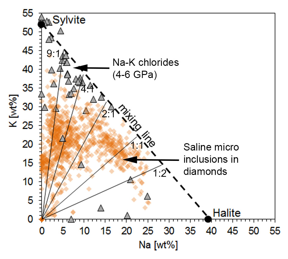
Pitfalls in the dating game: A cautionary tale
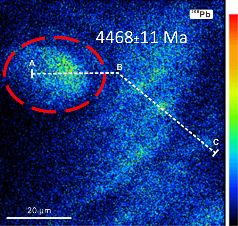
Contact: Simon Wilde
Funded by: CCFS Flagship Program 6
A new mechanism for the formation of diamond-bearing eclogites?
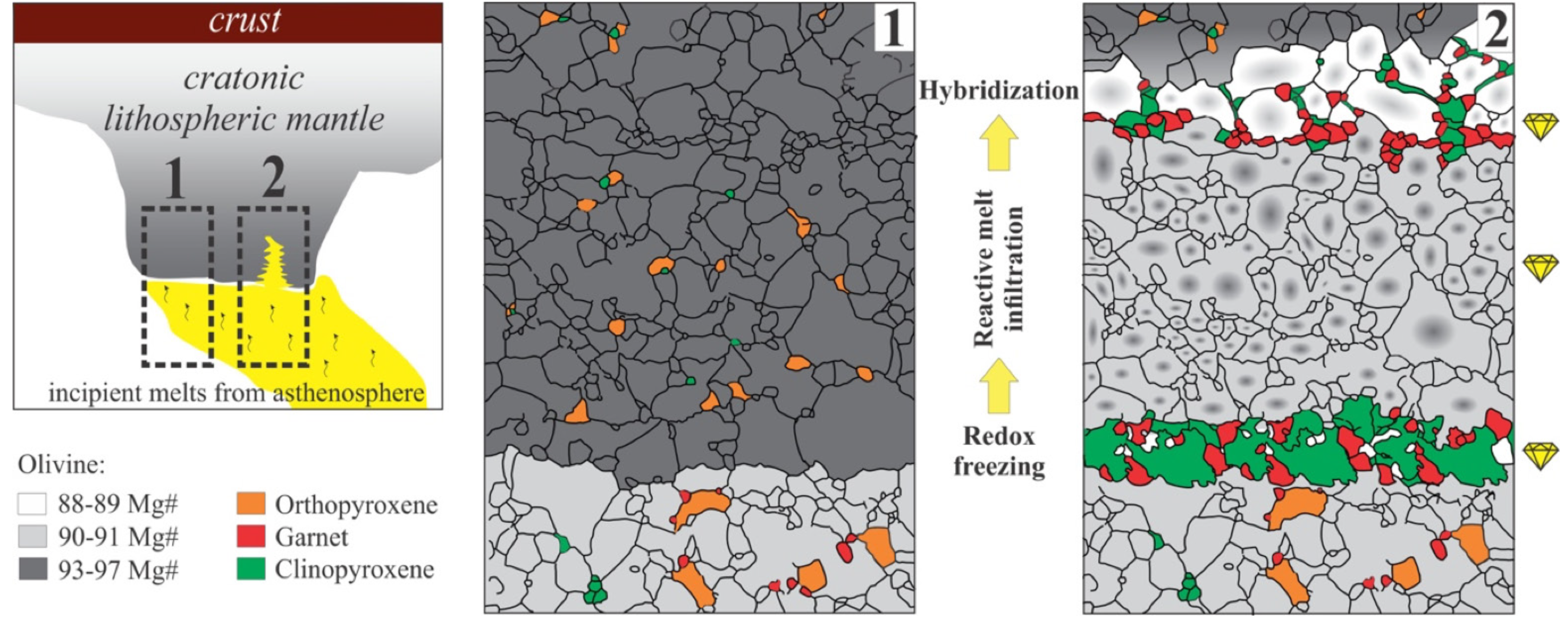
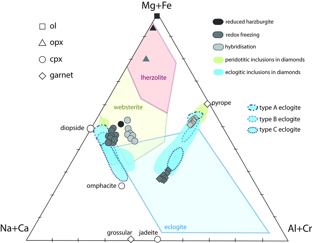
Contact: Zsanett Pintér
Funded by: Flagship program 3
Moissanite in the lithospheric mantle: Crystallisation from metallic melts
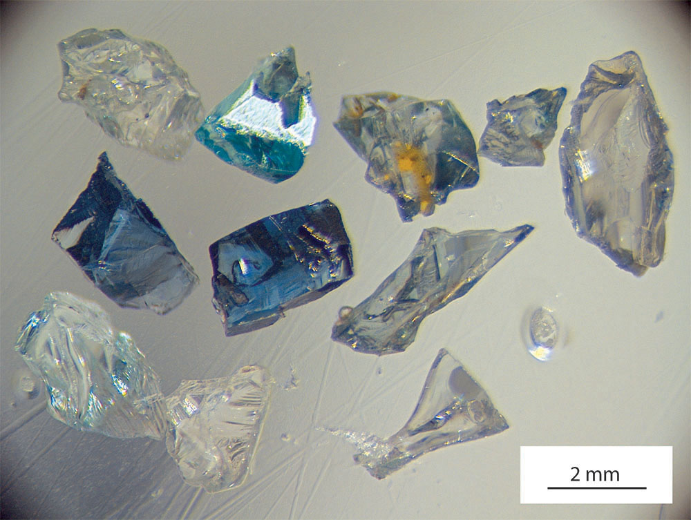
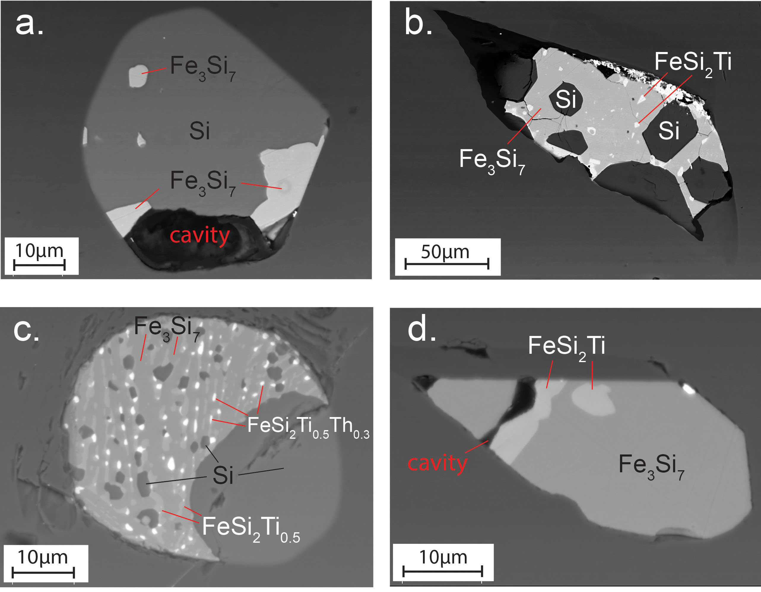
Contacts: Jin-Xiang Huang, Bill Griffin
FunFunded by: CCFS Flagship Program 1