Dr William Powell
PhD Macq.
GeochemistContact DetailsOffice : E7A 516 Dr William Powell |
 |
Profile
William Powell is a Research Officer in GEMOC, Department of Earth and Planetary Sciences, Macquarie University. William completed a PhD in which he mapped the lithosphere beneath the New England region of Eastern Australia using mantle xenoliths. During 2005, Will was part of the team updating GLITTER (GEMOC Laser ICPMS Total Trace Element Reduction) software to version 4.4, and took over GLITTER technical support and software development.
Fields of research
Thesis Research:
Thesis title: lithospheric Mapping in the New England Region, Eastern Australia.
Supervisors: Professors S. Y. O'Reilly and W. L. Griffin
I completed my PhD research program, which began by applying the 'lithosphere mapping' methodology to the New England Orogen, Eastern Australia. This involved using mantle xenoliths (fragments of the lower crust and upper mantle sampled by erupting lavas) to understand the history of the region and interpret its tectonic history and available regional geophysical data.
Geochemical and petrological analyses allow such things as the thermal regime and crustal thickness to be established, the melting history to be described, and metasomatic 'signatures' to be identified. In-situ isotopic analysis of Re and Os isotopes in sufides enclosed by the primary silicate phases can allow the age of formation of the lithosphere to be determined. More information about the Re-Os sulfide dating methodology can be found on the analytical methods page.
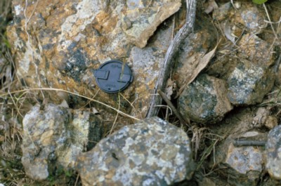 |
Mantle xenoliths in host rock from Lawler's Creek, New England Orogen, Eastern Australia. |
The New England Orogen is the easternmost and youngest structural element of the Australian continent, and was accreted at a former subduction zone during Phanerozoic time. Mantle xenoliths collected from a number of locations across the New England Orogen as part of this study have shown significant geochemical variations, indicating variations in crustal thickness and metasomatic history across the region
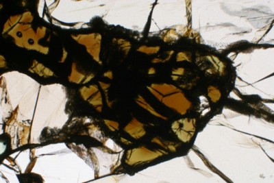 |
Thin-section of a xenolith from the Guyra locality, showing amphibole grains surrounding spinel. Two small holes in the top-left of the view are the result of in-situ laser ablation analysis for trace elements. Field of view is approx. 3.5 mm wide. |
The presence of amphibole in xenoliths at one of the New England localities has prompted further research into volatile-bearing phases and their role as hosts for trace elements. A suite of xenoliths from western Victoria (southeastern Australia) was selected, as they are known to contain abundant amphibole, as well as apatite and mica. These samples are the basis of the second part of my thesis research: an investigation into the role of volatile-bearing phases as trace-element hosts in the mantle, and as recorders of 'signatures' of mantle metasomatism.
Other Research:
The methodology used in lithosphere mapping can be applied wherever mantle material has been brought to the surface by erupting lavas. During the last few years I have been involved in collecting samples from sub-Antarctic islands in the southern Indian Ocean and study thereof.
At the start of 1999 I participated in a research expedition to Ilê Kerguelen, a French territory in the southern Indian Ocean. Kerguelen is of great scientific interest due to its location on the Kerguelen Plateau, which is the largest submarine plateau after the Ontong-Java. The plateau itself is exposed above sea level in only two locations, Kergeuelen and the Australian territory of Heard and McDonald Islands 400 km to the south. Studies of samples from Kerguelen are in progress by GEMOC postgraduate students Guillaume Delpech and Raynald Etienne. More information and photographs from the expedition can be seen here.
In the southern hemisphere summer of 2000/01 the Australian Antarctic Division sent a research expedition to the seldom-visited Australian territory of Heard Island. During the expedition I sampled mantle xenoliths from a number of localities on the island, which had not previously been reported. Study of these samples is complementary to the work of GEMOC and Universite Saint-Etienne. Photographs and more information about the expedition can be found here.
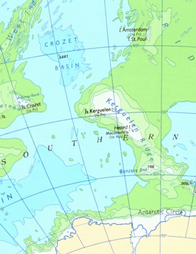 |
Map showing the extent of the Kerguelen Plateau, southern Indian Ocean. Australia is off to the east of the map, Africa is off to the west. The plateau rises over 3000 m above the surrounding seafloor, and is over 1500 km long in a north-south direction. It is exposed above sea level in only two locations: Kerguelen (Fr.) and Heard and McDonald Island (Aust.) |
Fieldwork
This section comprises a collection of photographs with comments from fieldwork in New England, western Victoria and Central Australia. Photographs from sub-Antarctic Heard Island and Kerguelen are also included, as well as a section of photographs from various bushwalking and camping trips. The starting point is the index located here.
Publications
Powell, W. and O'Reilly, S. Y. 2006. Metasomatism and sulfide mobility in lithospheric mantle beneath eastern Australia: implications for mantle Re-Os chronology. Lithos. (in press)
Powell, W., Zhang, M., O’Reilly, S.Y. and Tiepolo, M. 2004. Mantle amphibole trace-element and isotopic signatures trace multiple metasomatic episodes in lithospheric mantle, western Victoria, Australia. Lithos, 75, 141-171.